 Antiques (CA)
Africa Maps
Asia Maps
Australia/Oceania Maps
Celestial Maps
Central America/Caribbean Maps
Curiosities Maps
Digital Maps
Europe Maps
Map & Globe Mixed Lots
Map & Globe Reproductions
North America Maps
South America Maps
World & Celestial Globes
World Maps

-
$342.85 CAD

 Vtg 1984-1985 Aerial Photo Map Book California San Diego County Rare Atlas
-
$198.86 CAD
 Richard Yardley 1968 historical cartoon map of Baltimore County Maryland 16x20
-
$93.26 CAD
 CALIFORNIA Map 1912 ORIGINAL Counties Population Los Angeles San Diego Monterey
-
$176.92 CAD
 Vintage 1948 (36" x 23") MARYLAND MAP - HARFORD COUNTY Topo & Election Districts
-
$16.39 CAD
 Land Use & Cover 1974 Crater Lake Oregon, Diamond Lake 1974Us Geological Survey
-
$13.37 CAD
 Vintage ISLAND COUNTY, Washington Map 1930's or 40"s
-
$91.89 CAD
 1912 South Carolina Map ORIGINAL Counties Population McClellanville Georgetown
-
$94.47 CAD
 1912 NORTH DAKOTA Map ORIGINAL Counties Population Bismarck Boundary VINTAGE
-
$53.32 CAD
 VERMONT Map 1912 ORIGINAL Counties Population Montpelier Sand Gate Vintage
-
$67.04 CAD
 MINNESOTA Map 1912 ORIGINAL Counties Population Minneapolis St Paul Duluth
-
$60.34 CAD
 TENNESSEE Map 1912 ORIGINAL Counties Population Hill's Landseekers Atlas VINTAGE
-
$26.06 CAD
 Vintage Thomas Brothers OAKLAND Alameda County 1960s Map RARE Street
-
$79.54 CAD
 1953 NEW JERSEY Map Elizabeth Egg Harbor Sussex Cape May Woodbridge Howell
-
$253.72 CAD
 Rare 1940 Western Montana National Forest Map John B Lacasse & Sunday Missoulian
-
$53.32 CAD
 VINTAGE MARYLAND Map 1912 ORIGINAL Counties Population Annapolis Baltimore
-
$91.89 CAD
 1956 Minnesota Map ORIGINAL Minneapolis St Paul County Townships Railroads
-
$20.50 CAD
 1960-70 Historic Sites Map of Sonoma Valley 17.5x22.25 in.
-
$16.39 CAD
 Land Use & Cover 1974 Crater Lake Oregon, Diamond Lake 1974Us Geological Survey.
-
$54.84 CAD
 MINNESOTA COUNTY MAP BOOK PRINT COMMUNICATIONS COUNTY MINNESOTA 1990
-
$67.04 CAD
 New York State Map 1934 ORIGINAL County Township Brooklyn Long Island City Erie
-
$123.42 CAD
 1981 Map of Taiwan / Highway Map ( Mainroutes Mumbered ) 臺灣省地圖 / 臺灣省公路簡明交通圖
-
$63.02 CAD
 Old Original 1881 Plat Map ~ THE GREEN - WIER ST., TAUNTON, MA - HIGH ST.
-
$26.76 CAD
 Antique SCOTLAND Map Wall Art Decor Vintage Counties Original Edinburgh
-
$53.32 CAD
 ORIGINAL 1912 MISSISSIPPI Map Counties Populations Gulf Vicksburg Natchez
-
$65.67 CAD
 VINTAGE NEW YORK Map 1912 ORIGINAL Counties Long Island Buffalo Troy Albany
-
$13.70 CAD
 Texas Map Nueces County Corpus Christi Bay Encinal Padre Island Waldron Field TX
-
$38.33 CAD
 New Castle County Delaware 1962 Maintenance Map ~ Original Vintage ~ 19" x 24" b
-
$49.37 CAD
 Lot Of 3 original historical maps of Greencastle & Putnam County Indiana
-
$176.92 CAD
 Vintage 1949 LARGE MARYLAND MAP - HOWARD COUNTY Topography & Election Districts
-
$274.29 CAD
 Sueviae Circulus” engraving Wit, Frederik de Publisher 1680 Hand Colored
-
$205.72 CAD
 Vintage ORIGINAL WORLD MAP, rare
-
$205.72 CAD
 “Electoratus et Palatinatus Rheni (Map of the Historical Rhine Electorate)”
-
$13.70 CAD
 Texas Map - Runnels County Winters Ballinger Mills Rowena Wingate Norton TX
-
$20.56 CAD
 General Highway Map, Rock Island County Illinois, Vintage 1955, Rev 1984, Color
-
$13.70 CAD
 Texas Map - Kenedy County San Padre Island National Seashore Baffin Bay Sarita
-
$20.56 CAD
 1960 HAGSTROM POCKET ATLAS HUNTINGTON TOWNSHIP LONG ISLAND SUFFOLK COUNTY
-
$17.82 CAD
 Vintage Map Sweden Sverige Touring Service Europa BP 1963 Stockholm Artistic
-
$34.27 CAD
 ✨Vintage 1975 Bi-Centennial Historical Map Of Rutherford County NC- 20”x14”✨
-
$16.46 CAD
 Large Vintage VAN BUREN County Tennessee Highway Map, RR, Bridges & Much More
-
$4.99 CAD
 Bartholomew's Revised "Half-Inch" Contoured Maps Great Britain, 45 Mid-Scotland
-
$61.72 CAD
 Vintage 1936 Map Walworth County WI Vote For Joseph A. Dorr For Sheriff
-
$16.46 CAD
 1962 Benton County Iowa Electric Co-op Map 18 X 24" Vintage Map
-
$178.27 CAD
 1972 Chinese map of Taiwan 臺灣省地圖
-
$54.84 CAD
 WOODSTOCK 1969 FESTIVAL Planimetric Map LAKE HUNTINGTON QUADRANGLE 28”X23”
-
$137.13 CAD
 Ashland Bayfield Wisconsin WI Wis County Fold Out Maps 1917 ABSOLUTELY BEAUTIFUL
-
$10.96 CAD
 Vintage 1983 RICE County, Minnesota Rural Resident Directory Plat Book
-
$63.02 CAD
 Old 1915 Plat Map ~ SHELDON, OIL CITY, Twp., MONROE Co., WISCONSIN (LG14x17)
-
$27.42 CAD
 Vtg. Soil Survey Of Huron County Michigan USDA Maps 1980
-
$17.54 CAD
 Plat Map IL 1957 Randolph Township Advertisement McLean County
-
$34.22 CAD
 🦌1948🐟 LUCE COUNTY MICHIGAN HUNTING & FISHING MAP Upper Peninsula Newberry vtg
-
$63.02 CAD
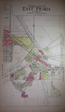 1929 Plat Map EAST PEORIA, TAZEWELL Co., IL / GREEN VALLEY, GARDENIA on Reverse
-
$13.70 CAD
 Texas Map Parmer County Farwell Bovina Friona Lariat Black Clays Corner Lariat
-
$13.70 CAD
 Texas Map Lee County Giddings Lexington Lake Somerville Dime Box Railroad TX
-
$63.02 CAD
 Old Original 1881 Plat Map ~ PRATT ST. - PLAIN ST., TAUNTON, MA - BERKLEY ST.
-
$17.47 CAD
 Vtg 1955 Barry County Michigan Dept Conservation Plat Maps 11" X 17"
-
$54.84 CAD
 5 Vintage Maps of Monmouth County New Jersey
-
$22.63 CAD
![#39220 Vintage map-Bonde Country [East Africa].Royal Geogr.Society England 1896.](https://i.ebayimg.com/thumbs/images/g/2KsAAOSwM~ddnJk4/s-l225.jpg) #39220 Vintage map-Bonde Country [East Africa].Royal Geogr.Society England 1896.
#39220 Vintage map-Bonde Country [East Africa].Royal Geogr.Society England 1896.
-
$24.00 CAD
 1941 - PROVINCE OF QUEBEC (CANADA) - HIGHWAY AND TOURIST - MAP - ORIGINAL
-
$63.02 CAD
 1929 Plat Map ~ SENECA, LA SALLE, Co., ILLINOIS / EAGLE, BRUCE on Reverse
-
$20.50 CAD
 Vintage 1947 Land Survey Map - Jefferson County, Alabama USA ~Hand Signed~
-
$10.96 CAD
 Vintage 2001 DODGE County Minnesota Rural Resident Directory Plat Book
-
$41.07 CAD
 New Castle County Delaware 1962 Maintenance Map ~ Original Vintage ~ 19" x 24" a
-
$63.02 CAD
 1929 Plat Map ~ WASHINGTON Twp, TAZEWELL Co., IL / GROVELAND - MORTON on Reverse
-
$20.56 CAD
![1950s Wonderful Britain map, Places to visit, North Scotland, 26x20cm [26717]](https://i.ebayimg.com/thumbs/images/g/TxEAAOSwsqVl4KSl/s-l225.jpg) 1950s Wonderful Britain map, Places to visit, North Scotland, 26x20cm [26717]
1950s Wonderful Britain map, Places to visit, North Scotland, 26x20cm [26717]
-
$63.02 CAD
 Old Original 1881 Plat Map ~ WHITTENTON MFG. CO., TAUNTON, MA - WARREN ST.
-
$27.36 CAD
 Topography Map of Fayette County, WV 1919 Original WV Geological Survey
-
$12.27 CAD
 1961 Road Map Delaware County PA
-
$20.56 CAD
 VINTAGE LAND ATLAS & PLAT BOOK 1987 COUNTY FREEBORN MINNESOTA ROCKFORD MAP
-
$31.50 CAD
 African Continental Cloth Map 24"x53" Flags Classroom Wall Hanging 1950s Africa
-
$63.02 CAD
 1912 Plat Map ~ HOLT Twp., DOUGLAS Co., MINNESOTA - PICKRELL ~ Free S&H
-
$38.39 CAD
 Rand-McNally city map: OZAUKEE COUNTY Wisconsin - © 1991 Seeger -
-
$63.02 CAD
 Old 1915 Plat Map ~ LA GRANGE, Twp., MONROE Co., WISCONSIN (LG14x17) Free S&H
-
$20.56 CAD
 VINTAGE LAND ATLAS & PLAT BOOK 1975 BECKER COUNTY MINNESOTA ROCKFORD MAP
-
$61.72 CAD
 Florida Lake Jesup Seminole County 1940’s Map
-
$20.57 CAD
 Vintage Bartholomew's Revised Half-inch Contoured Map Paper lot
-
$13.71 CAD
 Vintage Soviet Wall Map Southern Hemisphere 1981 in folder
-
$27.42 CAD
 Vtg. Soil Survey Of Monroe County Michigan USDA Maps 1981
-
$13.70 CAD
 Texas Map Kaufman County Terrell Plan Lawrence State Hospital Creeks Railroads
-
$15.42 CAD
![1950s Wonderful Britain map, Places to visit, Newcastle, 26x20cm [26722]](https://i.ebayimg.com/thumbs/images/g/hhgAAOSwSoFl4KTl/s-l225.jpg) 1950s Wonderful Britain map, Places to visit, Newcastle, 26x20cm [26722]
1950s Wonderful Britain map, Places to visit, Newcastle, 26x20cm [26722]
-
$13.70 CAD
 Texas Map Rusk County Henderson Tatum Kilgore Rexlaw Overton Mount Enterprise TX
-
$13.70 CAD
 Texas Map Rusk County Henderson Lake Forest Park Airport Highways Railroads TX
-
$95.93 CAD
 1746 Map of Hertfordshire England - Thomas Kitchin - Hartfordshire - Temperance
-
$13.70 CAD
 VINTAGE LAND ATLAS & PLAT BOOK 1997 BELTRAMI COUNTY MINNESOTA ROCKFORD MAP
-
$10.96 CAD
 Vintage 2002 BLUE EARTH County, Minnesota Rural Resident Directory Plat Book
-
$28.36 CAD
 Old Vintage 1925 State & County Map ~ MISSISSIPPI ~ Free S&H
-
$13.70 CAD
 VINTAGE LAND ATLAS & PLAT BOOK 1996 AITKIN COUNTY MINNESOTA ROCKFORD MAP
-
$63.02 CAD
 Old Authentic 1874 Plat Map ~ BENTON HARBOR Twp., BERRIEN Co., MICHIGAN (15x18)
-
$15.42 CAD
![1950s Wonderful Britain map, Places to visit, Oxford Portsmouth, 26x20cm [26762]](https://i.ebayimg.com/thumbs/images/g/PLgAAOSwdq9k4NT3/s-l225.jpg) 1950s Wonderful Britain map, Places to visit, Oxford Portsmouth, 26x20cm [26762]
1950s Wonderful Britain map, Places to visit, Oxford Portsmouth, 26x20cm [26762]
-
$13.70 CAD
 VINTAGE LAND ATLAS & PLAT BOOK 2021 COUNTY CARLTON MINNESOTA ROCKFORD MAP
-
$13.70 CAD
 Texas Map Hill County Hillsboro Plan Aquilla Lake Parks Railroad Highway Vintage
-
$17.47 CAD
 Vtg 1955 Washtenaw County Michigan Dept Conservation Plat Maps 11"X17"
-
$27.42 CAD
 Moline Illinois 1963 Vintage Ward Precinct Map Rock Island County Quad Cities
-
$13.70 CAD
 Texas Map - Kenedy County San Padre Island National Seashore Ranches Oil Fields
-
$10.96 CAD
 Vintage 1986 ROCK NOBLES County Minnesota Rural Resident Directory Plat Book
-
$15.94 CAD
![1950s Wonderful Britain map, Places to visit, Manchester, 26x20cm [26727]](https://i.ebayimg.com/thumbs/images/g/BS8AAOSwDDJljDRH/s-l225.jpg) 1950s Wonderful Britain map, Places to visit, Manchester, 26x20cm [26727]
1950s Wonderful Britain map, Places to visit, Manchester, 26x20cm [26727]
-
$68.56 CAD
 Lakeland Florida Map Polk County 1929 Mendenhall Original
-
$16.44 CAD
 Texas Map - Hidalgo County - McAllen Edinburg Weslaco Mission Mercedes Alamo TX
-
$13.70 CAD
 Texas Map - Cameron County - Harlingen La Feria Palm Valley Primera Combes Towns
-
$27.42 CAD
 Vtg Ravalli County Montana Road Index Map Collection FIRST EDITION Large 24"x18"
-
$68.57 CAD
 55 Vintage 1960s Michigan County Wall Maps DNR 22 Different Counties


