 Antiques (CA)
Africa Maps
Asia Maps
Australia/Oceania Maps
Celestial Maps
Central America/Caribbean Maps
Curiosities Maps
Digital Maps
Europe Maps
Map & Globe Mixed Lots
Map & Globe Reproductions
North America Maps
South America Maps
World & Celestial Globes
World Maps

-
$16.11 CAD

 1966 ANTARCTIC EXPLORATIONS Atlas Map, vintage World Book Atlas color South Pole
-
$54.83 CAD
 1962 Becvar Star Map 4 North Sky Chart Hercules Bootes Corona Borealis Astronomy
-
$16.11 CAD
 1966 PENNSYLVANIA Atlas Map, vintage World Book Atlas, full color
-
$16.11 CAD
 1966 MISSISSIPPI Atlas Map, vintage World Book Atlas, full color
-
$15.00 CAD
 1963 United Airlines Airline Atlas Map of The United States USA
-
$383.78 CAD
 c. 1842 Middleton Star Map Spring Constellations Equitorial Hydra Leo Gemini Sky
-
$36.08 CAD
 Vintage 1969 Pictorial Map ~ UKRAINE, CRIMEA, MOLDAVIA, USSR ~ Free S&H
-
$36.08 CAD
 1969 Pictorial Map ~ POLITICAL ADMINISTRATIVE DIVISIONS of the USSR A. Nazaroff
-
$383.78 CAD
 c. 1842 Middleton Star Map Summer Constellations Hercules Bootes Virgo Scorpio
-
$65.79 CAD
 1962 Becvar Star Map 5 North Sky Chart Milky Way Lacerta Galactic Astronomy
-
$41.11 CAD
 1969 Adriatic Sea Taunton Nautical Chart Map Italy Albania & Yugoslavia 1440 Map
-
$28.35 CAD
 1965 Vernon Quinn Pictorial Map ~ WEST INDIES - CARIBBEAN SEA ~ Maps by Da Osimo
-
$383.78 CAD
 c. 1842 Middleton Star Map Autumn Fall Constellations Pegasus Aquarius Andromeda
-
$16.11 CAD
 1966 WISCONSIN Atlas Map, vintage World Book Atlas, full color
-
$16.11 CAD
 1966 JAPAN + KOREA Atlas Map, vintage World Book Atlas, full color
-
$16.11 CAD
 1966 CALIFORNIA Atlas Map, vintage World Book Atlas, full color
-
$36.08 CAD
 Vintage 1969 Pictorial Map ~ THE CAUCASUS, USSR ~ Free S&H
-
$54.81 CAD
 1962 Becvar Star Map XIII Astronomy South Sky Chart Milky Way Centaurus Lupus
-
$28.35 CAD
 1965 Vernon Quinn Pictorial Map ~ GUATEMALA & BELIZE ~ Maps by Da Osimo
-
$28.35 CAD
 1967 Vintage Air Atlas Map ~ UNITED AIRLINES ~ UNITED STATES ROUTE / SYSTEMS MAP
-
$16.11 CAD
 1966 NE AFRICA Atlas Map, vintage World Book Atlas, color Libya Egypt Tunisia
-
$28.35 CAD
 1965 Vernon Quinn Pictorial Map ~ CUBA - CARIBBEAN SEA ~ Maps by Da Osimo
-
$171.33 CAD
 VINTAGE 1970's Marion County Florida Real Estate Atlas MAPS/PLATS
-
$54.83 CAD
 1962 Becvar Star Map 9 Equatorial Sky Chart Libra Virgo Bootes Nebula Astronomy
-
$28.35 CAD
 Old 1969 Pictorial Map ~ THE URALS, SIBERIA, THE FAR EAST, USSR ~ Free S&H
-
$6.84 CAD
 Vintage Rand McNally World Atlas 1964-Learn Teach Maps-No Missing Pages12.5x9.5”
-
$65.79 CAD
 1962 Becvar Star Map X Equatorial Sky Chart Milky Way Nebula Aquila Astronomy
-
$383.78 CAD
 c. 1842 Middleton Star Map North Sky Polaris Pole Constellations Draco Cepheus
-
$16.11 CAD
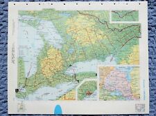
 1961 N BRUNSWICK-PEI-N SCOTIA CANADA Atlas Map, vintage Life Rand McNally Atlas
-
$16.11 CAD
 1966 Atlas Map, US Westward Expansion 1800-1850, vintage World Book Atlas, color
-
$16.11 CAD
 1966 SASKATCHEWAN CANADA Atlas Map, vintage World Book Atlas, full color
-
$16.11 CAD
 1966 NEW YORK Atlas Map, vintage World Book Atlas, full color
-
$65.79 CAD
 1962 Becvar Star Map 7 Equatorial Sky Chart Milky Way Monoceros Orion Astronomy
-
$10.58 CAD
 Vintage Atlas World Book Map Tennessee Or Texas USA State 1962 Page 11inx14in
-
$36.08 CAD
 1969 Pictorial Map ~ THE VOLGA REGION, USSR ~ A. Nazaroff & T. LoPrete ~Free S&H
-
$54.83 CAD
 1962 Becvar Star Map 6 Equatorial Sky Chart Pisces Cetus Aires Glactic Astronomy
-
$65.79 CAD
 1962 Becvar Star Map 1 North Sky Chart Pole Polaris Cepheus Milky Way Astronomy
-
$28.35 CAD
 1965 Vernon Quinn Pictorial Map ~ HONDURAS - EL SALVADOR ~ Maps by Da Osimo
-
$16.11 CAD
 1966 PACIFIC ISLANDS Atlas Map, vintage World Book Atlas, full color
-
$16.11 CAD
 1966 CONNECTICUT + RHODE ISLAND Atlas Map, vintage World Book Atlas, full color
-
$16.11 CAD
 1966 ISRAEL + EGYPT Atlas Map, vintage World Book Atlas, full color
-
$123.69 CAD
 SOVIET UNION USSR Strategic Area Maps Lot Of 2 Political Railroad, Mineral Huge
-
$383.78 CAD
 c. 1842 Middleton Star Map Winter Constellations Aires Taurus Cetus Orion Lepus
-
$28.35 CAD
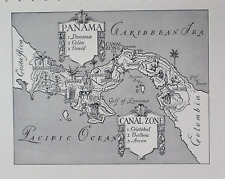 1965 Vernon Quinn Pictorial Map ~ PANAMA - CANAL ZONE ~ Maps by Da Osimo
-
$205.58 CAD
 Vintage Framed 1964 National Geographic Shakespeare's Britain England & Ireland
-
$16.11 CAD
 1966 POLAND + CZECHOSLOVAKIA Atlas Map, vintage World Book Atlas, full color
-
$10.58 CAD
 Vintage Atlas World Book Map Germany Or Belgium NetherlandsEurope Page 11inx14in
-
$36.08 CAD
 1969 Pictorial Map ~ THE EUROPEAN NORTH, USSR ~ A. Nazaroff & T. LoPrete
-
$16.11 CAD
 1966 CHINA + MONGOLIA Atlas Map, vintage World Book Atlas, full color
-
$43.85 CAD
 1962 Becvar Star Map Astronomy South Sky Sagittarius Corona Australis Milky Way
-
$38.36 CAD
 1962 Becvar Star Map XII Equatorial Sky Chart Phoenix Fornax Nebula Astronomy
-
$16.11 CAD
 1966 SPAIN + PORTUGAL Atlas Map, vintage World Book Atlas, full color
-
$37.21 CAD
 1965 Vernon Quinn Pictorial Map ~ MEXICO ~ Maps by Da Osimo ~ Free S&H
-
$16.11 CAD
 1966 TEXAS Atlas Map, vintage World Book Atlas, full color
-
$16.11 CAD
 1966 INDIA + PAKISTAN Atlas Map, vintage World Book Atlas, full color
-
$36.08 CAD
 1969 Pictorial Map THE CENTRAL BLACK EARTH REGION, USSR ~ A. Nazaroff T. LoPrete
-
$16.11 CAD
 1966 AFRICA Atlas Map, vintage World Book Atlas, color, African physical map
-
$16.11 CAD
 1966 NORTH CAROLINA Atlas Map, vintage World Book Atlas, full color
-
$36.08 CAD
 1969 Pictorial Map ~ THE BALTIC, REPUBLICS, KALININGRAD, BELORUSSIA, USSR
-
$16.11 CAD
 1966 SOUTHERN AFRICA Atlas Map, vintage World Book Atlas, color , Madagascar
-
$54.83 CAD
 1962 Becvar Star Map XI Equatorial Sky Chart Milky Way Nebula Aquarius Astronomy
-
$65.78 CAD
 1962 Becvar Star Map Astronomy South Pole Sky Hydrus Apus Carina Indus Milky Way
-
$65.79 CAD
 1962 Becvar Star Map 2 North Sky Chart Milky Way Andromeda Perseus Astronomy
-
$54.83 CAD
 1962 Becvar Star Map 3 North Sky Chart Milky Way Orion Ursa Maior Leo Astronomy
-
$54.83 CAD
 1962 Becvar Star Map 8 Equatorial Sky Chart Milky Way Hydra Sextans Astronomy
-
$54.81 CAD
 1962 Becvar Star Map XIV Astronomy South Sky Chart Vela Centaurus - Milky Way
-
$16.11 CAD
 1966 EAST & WEST GERMANY & AUSTRIA Atlas Map, vintage World Book Atlas, color
-
$16.11 CAD
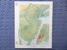 1966 NEW JERSEY Atlas Map, vintage World Book Atlas, full color
-
$16.11 CAD
 1966 MASSACHUSETTS Atlas Map, vintage World Book Atlas, full color
-
$16.11 CAD
 1966 GEORGIA Atlas Map, vintage World Book Atlas, full color
-
$34.27 CAD
 Large Vintage Map Of Australia Rand Mcnally 44"×31"
-
$16.11 CAD
 1961 ALBERTA CANADA Atlas Map, vintage Time Life Rand McNally Atlas, full color
-
$16.11 CAD
 1966 SCOTLAND + NORTHERN ENGLAND Atlas Map, vintage World Book Atlas, full color
-
$29.48 CAD
 1967 Rand McNally Atlas Map ~ JAPAN, NORTH - SOUTH KOREA, CHINA, SOVIET UNION
-
$47.97 CAD
 Pictorial World Atlas Life Rand McNally 1961 Maps Geography
-
$16.11 CAD
 1966 FLORIDA Atlas Map, vintage World Book Atlas, full color
-
$16.11 CAD
 1966 WASHINGTON STATE Atlas Map, vintage World Book Atlas, full color
-
$16.11 CAD
 1961 MANITOBA CANADA Atlas Map, vintage Time Life Rand McNally Atlas, full color
-
$37.21 CAD
 1969 Pictorial Map ~ THE URALS, SIBERIA, THE FAR EAST, USSR ~ Free S&H
-
$171.26 CAD
 1960 WASHINGTON DC ZOOLOGICAL PARK TO PROTESTANT EPICOPAL CATHEDRAL ATLAS MAP
-
$23.29 CAD
 Vintage Springfield, Illinois - City Town Map, City Water Power Light 1964
-
$10.58 CAD
 Vintage Atlas World Book Map Italy Or Yugoslavia Hungary Europe Page 11inx14in
-
$108.56 CAD
 1960 Photographic Lunar Moon Map - 4 Photo Set - Field Furnerius A7 - Craters
-
$16.11 CAD
 1966 WYOMING Atlas Map, vintage World Book Atlas, full color
-
$16.11 CAD
 1966 SCANDINAVIA + ICELAND Atlas Map, vintage World Book Atlas, full color
-
$16.11 CAD
 1961 SASKATCHEWAN CANADA Atlas Map, vintage Time Life Rand McNally Atlas
-
$16.11 CAD
 1966 LOUISIANA Atlas Map, vintage World Book Atlas, full color
-
$16.11 CAD
 1966 ARGENTINA+CHILE Atlas Map, vintage World Book Atlas, full color
-
$16.11 CAD
 1966 ONTARIO CANADA Atlas Map, vintage World Book Atlas, full color
-
$16.11 CAD
 1966 OHIO Atlas Map, vintage World Book Atlas, full color
-
$16.11 CAD
 1966 ITALY Atlas Map, vintage World Book Atlas, full color
-
$16.11 CAD
 1966 ASIA Atlas Map, vintage World Book Atlas, full color
-
$108.56 CAD
 1960 Photographic Lunar Moon Map - 4 Photo Set - Field Gauss A2 Surface Craters
-
$16.11 CAD
 1966 VERMONT Atlas Map, vintage World Book Atlas, full color
-
$16.11 CAD
 1966 ILLINOIS Atlas Map, vintage World Book Atlas, full color
-
$181.28 CAD
 1960s Orbis Terrarum... Hemisphaeriis Comprehesa Map by Geelkercken- Wood Copper
-
$16.11 CAD
 1966 EUROPE Atlas Map, vintage World Book Atlas, full color, European political
-
$16.11 CAD
 1966 EUROPE Atlas Map, vintage World Book Atlas
-
$16.11 CAD
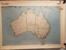
 1966 AUSTRALIA Atlas Map, vintage World Book Atlas, color, physical, Tasmania
-
$16.11 CAD
 1961 ONTARIO CANADA Atlas Map, vintage Time Life Rand McNally Atlas, full color


