 Antiques (CA)
-
$292.54 CAD

 Italy Italia c.1770 Isaak Tirion rare folio sheet antique map not in Borri
-
$156.79 CAD
 1758 Map, “Rade et Ville de la Vera-Cruz, vera Cruz, Mexico, by Schley
-
$61.95 CAD
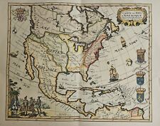 Carte Des Pays D'Amerique SEPTENTRIONALE Dresses en 1778 (20th Century Litho)
-
$14.45 CAD
 Map Revolutionary War South Colonies 1871 Victorian Woodcut Print History DWAA12
-
$64.98 CAD
 Historic Map Groton Conn 1655-1799 Town Owner Names Genealogy Date Unknown
-
$55.07 CAD
 Oyster and Huntington Bays 1778 Published by an Act of Parliament Repro.
-
$275.33 CAD
 2 America Island Maps by Jean Baptist Anville Circa 1730 Hispaniola Mexican Gulf
-
$1098.57 CAD
 1795 Rare antique map of Pennsylvania based on Reading Howell's Map Samuel Lewis
-
$206.50 CAD
 1787 Rigobert Bonne Mappemonde Occidental Western Hemisphere Antique Map
-
$38.55 CAD
 Map Of Baltimore Town. Print On Smooth Paper.
-
$1084.11 CAD
 Antique "Map of the British and French Settlements in North America" 1755
-
$19.27 CAD
 Map Sherman's Army Virginia Operations 1871 Victorian Lithograph History DWAA12
-
$240.91 CAD
 Antique 1787 French Maritime Hydrography Map Eastern Coast United States M Bonne
-
$52.31 CAD
 CAPTAIN LYON / FINDEN c1823 Engraving Eskimo of Igloolik Takkelikketa Sxcarce
-
$103.25 CAD
 Plan of The City Of New York Map-Surveyed 1782-1785/Read All Details
-
$1204.57 CAD
 RARE 1794 Early Map of South Carolina by Stockdale, Morse, American Geography SC
-
$1080.67 CAD
 1792 Bowles’ New One Sheet Map of Jamaica...
-
$413.00 CAD
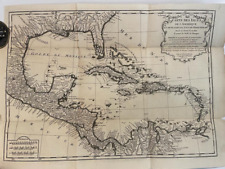
 ANTIQUE CIRCA 1750's ORIG. WEST INDIES MAP with FLORIDA - THOMAS JEFFERYS
-
$41.30 CAD
 Draught of the Entrance of Mobile Bay, Taken in Kings Ship Nautilus in year 1764
-
$44.05 CAD
 Matthew Seutter 1735 U.S. map repro vtg 1960s ~ Penn Prints ~ trimmed to 24x20"
-
$413.00 CAD
 1794 "A New Map of North America" - Gorgeous Antique Map
-
$3441.56 CAD
 Very Fine, Early Map Of The United States, Circa The 1760's, From A Copper Plate
-
$3441.56 CAD
Early Map Of The United States, Circa The 1760's, From A Copper Plate, Very Fine


