 Antiques (CA)
-
$275.11 CAD

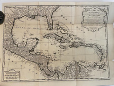
 Central America Mexico Yucatan Honduras Guatemala 1754 Bellin engraved map
-
$300.00 CAD
 ANTIQUE ENGRAVED PRINT
-
$378.28 CAD
 1780 Bonne Map of Southwest America and New Spain
-
$32.94 CAD
 1740s “New Jersey, Pennsylvania, New York” Vintage Style Land Map - 24x30
-
$24.69 CAD
 1700s New World Spanish Colonies Old Map - 20x28
-
$23.32 CAD
 North America 1771 Colonial Map - 13 Colonies - 20x24
-
$32.94 CAD
1771 Early American 13 Colonies - East Coast Map - 24x28
-
$17.88 CAD
 1943 Vintage Map - Indian Land Cessions 1784-1798 - Kentucky - Ohio - Tennessee
-
$23.32 CAD
Historic Map of New England 1747 Vintage Style Colonial Map - 20x24
-
$17.81 CAD
 1796 PENNSYLVANIA CYRUS HARRIS MAP MANY OLD TOWN NAMES WITH LONG “S”(f) PRINTING
-
$66.03 CAD
 Hudson Bay Canada Map America Amerique Engraving Map Carte Bellin 1758
-
$825.33 CAD
 NORTH AMERICA CALIFORNIA AS AN ISLAND 1706 DE LA FEUILLE ANTIQUE MAP
-
$240.71 CAD
 1780 - BONNE - Map USA TEXAS NEW MEXICO LOUISIANA BAJA CALIFORNIA
-
$34.32 CAD
 1718 Lousiana Territory & Mississippi River Historic Map - 24x32
-
$34.39 CAD
 1708 Antique Map North American Reproduction British American Colonies Vtg
-
$287.05 CAD
 1773 Bellin, map, Hudson Bay, Canada, James BAY, Labrador
-
$405.79 CAD
 RARE ANTIQUE MAP OF CANADA AND UNITED STATES AMERICA USA GUILLAME DEL'ISLE 1783
-
$81.16 CAD
 Historic Map Groton Conn 1655-1799 Town Owner Names Genealogy Date Unknown
-
$18.57 CAD
 Map Revolutionary War South Colonies 1871 Victorian Woodcut Print History DWAA12
-
$23.32 CAD
 1750s L' Amerique Septentrionale New World Map - 20x24
-
$206.33 CAD
 1787 Rigobert Bonne Mappemonde Occidental Western Hemisphere Antique Map
-
$37.81 CAD
 1877 RARE ORIGINAL ENGRAVING UNITED STATES WASHINGTON, D.C. CAPITOL panorama
-
$23.32 CAD
 1747 Map of the Gulf Coast - Louisiana to Florida - 20x24
-
$19.19 CAD
 Carolina 1732 Interesting Old Historic Map - 18x24
-
$19.19 CAD
North America 1718 Louisana Territory Historic Map - 18x24
-
$171.93 CAD
 1756 (1780) - BELLIN - CANADA Map GULF OF SAINT LAWRENCE NEWFOUNDLAND & ISLANDS
-
$906.35 CAD
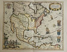
 1744 Georg Mattaus Seutter Antique Map of North America - California as Island
-
$19.19 CAD
 1770s Early Map of Connecticut, New Jersey, New York & Long Island - 16x20
-
$295.74 CAD
 Antique Map - 1770 Original Map of North America by Thomas Bowen
-
$247.60 CAD
 Saint-Domingue Dominican Republic Hispaniola 1754 Bird's Eye View City Plan
-
$385.15 CAD
 Quebec City Canada City Plan 1792 Neele scarce detailed engraved hand color map
-
$17.88 CAD
 1943 Vintage Map - Charleston South Carolina in 1776 - Revolutionary War
-
$171.94 CAD
 Canada, Du Fleuve De St. Laurent, Old map Bellin 1757
-
$156.66 CAD
 1758 Map, “Rade et Ville de la Vera-Cruz, vera Cruz, Mexico, by Schley
-
$37.81 CAD
 1877 RARE ORIGINAL ENGRAVING UNITED STATES CHARLESTON SOUTH CAROLINA Meeting St.
-
$17.88 CAD
 1943 Vintage Map - British Florida 1763-1783 - St. Augustine Alabama, Louisiana
-
$275.10 CAD
 1794 AMERICAN UNIVERSAL GEOGRAPHY 9 MAPS 1ST US SCHOOL GEOGRAPHY COMPLETE
-
$275.11 CAD
 2 America Island Maps by Jean Baptist Anville Circa 1730 Hispaniola Mexican Gulf
-
$275.10 CAD
 Antique Reprint Map Of The 1765 British Colonies
-
$275.11 CAD
 Italy Italia c.1770 Isaak Tirion rare folio sheet antique map not in Borri
-
$19.19 CAD
1740s Early Map of the Gulf Coast - Texas, Louisiana, Florida - 16x20
-
$32.94 CAD
1740s Map of the New Orleans and the Gulf Coast - 24x30
-
$34.32 CAD
 Map of the Mississippi River and Louisiana 1730 Vintage Style US Map - 24x32
-
$24.69 CAD
1732 Carolina Historic Old American Map - 20x28
-
$1.38 CAD
 Virginia Revolutionary War Map 1774 1783 Independence Bicentennial Commission
-
$24.69 CAD
1730 Mississippi River Louisiana Territory Historic Vintage Style Wall Map 20x28
-
$37.81 CAD
 1850 RARE NICE ORIGINAL ENGRAVING NEW YORK STAATEN-ISLAND panoramic city view
-
$19.19 CAD
1750s Early North America New World Exploration Map - 16x20
-
$148.56 CAD
 Vera Cruz Mexico Fort St. Jean d'Ulva Harbor Depths 1754 Bellin hand color map
-
$137.55 CAD
 VIRGINIA FLORIDA PEOPLE 1733 ANTIQUE ENGRAVED VIEW 18TH CENTURY
-
$13.74 CAD
 American Revolutionary War Washington's March to Yorktown New Jersey Virginia
-
$19.19 CAD
 1700s “Map of New France” Vintage Style Early United States Map - 16x20
-
$17.88 CAD
 1943 Vintage Map - Boston in 1775 and 1776 - Revolutionary War - Bunker Hill
-
$1471.84 CAD
 1717 MAP of AMERICA antique authentic CALIFORNIA AS AN ISLAND L'Amerique
-
$247.60 CAD
 1760 ANTIQUE GENTLEMAN'S MAGAZINE MAP OF QUEBEC ONTARIO WITH MONTREAL INSET MAP
-
$19.19 CAD
 1759 New England NY NJ PA Historic Old German Map - 18x24
-
$61.89 CAD
 1875 UNUSUAL ORIGINAL MAP SANDWICH ISLANDS HAWAII UNITED STATES HONOLULU OAHU
-
$174.61 CAD
 Florida Louisiana Virginia New Orleans Georgia America Card Map Bonne 1780
-
$1650.66 CAD
 1776 Tobias Lotter Antique Post Revolutionary North America Map 13 Colonies
-
$19.19 CAD
1730s “Carte de la Louisiane et Mississippi” Vintage Style French Map - 18x24
-
$32.94 CAD
 1759 North America Map of New Spain Spanish Colonies - 24x30
-
$1031.66 CAD
 Nice AMERICAN COLONIES Colonial MAP & George Washington at 22 Yrs. 1754 Magazine
-
$137.55 CAD
 1780 Partie Meridionale De L'Ancien Mexique ou de la Nouve le Espagne. R Bonne
-
$19.19 CAD
 Bird's Eye View 1755 Quebec Canada Vintage Style City Map - 18x24
-
$1925.77 CAD
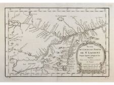
 Carte D’Une Partie De L’Amerique Septentrionale, pour servir a l’Histoire...
-
$254.48 CAD
 North America map Saint Lawrence River Great Lakes Bellin 1757
-
$385.15 CAD
 SOUTHWEST UNITED STATES 1788 RIGOBERT BONNE ANTIQUE ENGRAVED MAP 18TH CENTURY
-
$481.44 CAD
 Original 1781 Map Carta Del Golfo Dell' Isole Antille Florida & Gulf Coast
-
$32.94 CAD
1718 Carte De La Nouvelle France Historic Vintage Style Wall Map - 24x28
-
$37.81 CAD
 1854 nice UNUSUAL ORIGINAL engraving CANADA QUEBEC CITY panoramic view HARBOR
-
$41.25 CAD
 1877 RARE ORIGINAL ENGRAVING UNITED STATES SAN FRANCISCO CALIFORNIA CHINA TOWN
-
$34.37 CAD
 “Order Of Battle For 1781” Published 1847 In Facsimile From Washington’s Journal
-
$825.33 CAD
 USA CANADA COLONIAL TERRITIORIES 1777 HOMANN HRS LARGE ANTIQUE MAP 18TH CENTURY
-
$27.44 CAD
 Vintage Map The Town of Boston Mass 1722 Captain John Bonner 11" x 15 1/2"
-
$171.94 CAD
 Greece crete 1719 Paris by chiquet antique map
-
$687.77 CAD
 CALIFORNIA & BAJA CALIFORNIA 1772 ROBERT DE VAUGONDY/DIDEROT LARGE ANTIQUE MAP
-
$88.05 CAD
 1760 J. van der Schley, Ancient Mexico City, foreign topography, map
-
$5674.14 CAD
 1730 Georg Seutter Antique Map of New England & New York City - Rare 2nd State
-
$61.90 CAD
 Carte Des Pays D'Amerique SEPTENTRIONALE Dresses en 1778 (20th Century Litho)
-
$359.99 CAD
 1762 Original Map Of the Island of Jamaica by J. Gibson 1762 Framed Antique Art
-
$20.62 CAD
 Antique Map "Palaestine" 1747, Copperplate Engraving
-
$19.19 CAD
North America 1703 Historic Spanish Territory Vintage Style Map - 18x24
-
$2722.08 CAD
 1756 Homann Antique Map Original 13 Colonies of North America, French Indian War
-
$302.62 CAD
 NORTH AMERICA 1780 RIGOBERT BONNE ANTIQUE ENGRAVED MAP 18TH CENTURY
-
$4057.87 CAD
 RARE LARGE ORIGINAL 1797 MAP OF HAWAII LAPEROUSE - EX PAUL KAHN COLLECTION
-
$598.36 CAD
 Rare WEST FLORIDA Louisiana Pensacola FL Mississippi River MAP 1772 Old Magazine
-
$27.44 CAD
 MAP: NEW FRANCE IN 1719, Repro 17.5 x 23 inches, Carte de la Nouvelle France
-
$226.97 CAD
 1753 Bellin & Henry Ellis Antique Map of Hudsons Bay, Search NW Passage
-
$686.40 CAD
 Antique Florida Louisiana North South Carolina Virginia Map 1700's by Santini
-
$34.32 CAD
 Savannah Georgia 1734 Historic Panoramic Town Map - 24x32
-
$43.33 CAD
 Map Shawmut Trimountain c1630 Boston 1925 Historical Massachusetts DWX3A
-
$894.11 CAD
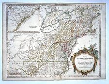 NORTH AMERICA OHIO NEW ENGLAND c. 1760 ROBERT DE VAUGONDY LARGE ANTIQUE MAP
-
$23.32 CAD
1750s Detailed Map of New Spain and the Spanish Colonies - 20x24
-
$330.13 CAD
 LOUISIANA FLORIDA 1780 RIGOBERT BONNE ANTIQUE MAP IN COLORS 18TH CENTURY
-
$37.81 CAD
 1850 NICE ORIGINAL ENGRAVING UNITED STATES BALTIMORE MARYLAND panorama city view
-
$34.39 CAD
 Framed Map of Historical Ride of Paul Revere,William Davis,Dr.Prescott
-
$61.89 CAD
 1872 RARE NICE ORIGINAL ENGRAVING CHICAGO ILLINOIS panoramic city view
-
$23.32 CAD
1777 Map of Connecticut, Long Island & Manhattan 20x24
-
$343.89 CAD
 Antique Map "Carte De La Lousiane et Pays Voifins" 1757
-
$446.37 CAD
 Antique Print-PLAN-QUEBEC-CANADA-Bellin-Schwabe-1758


