 Antiques (CA)
-
$104.17 CAD

 1873 Mitchell's Map of New Hampshire and Vermont, Authentic Hand-Colored Antique
-
$61.67 CAD
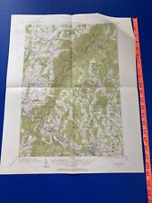
 Map Bellows Falls NH Vermont 1957 Topographic Geo Survey 1:62500 22 x 18" TOPO3
-
$109.65 CAD
 1879 Map New England USA Victorian Atlas Harpers Geography 1st Edition DWAA9
-
$137.09 CAD
 Antique Johnson's Map Of New Hampshire and Vermont 1863 Civil War Era Old Map
-
$33.50 CAD
 Vintage 1903 VERMONT Map 14"x22" ~ Old Antique Original MONTPELIER WOODSTOCK VT
-
$24.68 CAD
 1953 VINTAGE MAP OF VIRGINIA / VERSO VERMONT
-
$22.15 CAD
 1939 Antique Vermont State Map Original Map of VERMONT Gallery Wall Art Map 9324
-
$35.57 CAD
 Rand-McNally regional state map: EASTERN UNITED STATES © 2004 - paper
-
$23.30 CAD
 Vermont & New Hampshire - Original 1902 Map by Dodd Mead & Company
-
$27.68 CAD
 1943 VINTAGE WWII MAP OF VIRGINIA / VERMONT
-
$38.37 CAD
 1881 Rand McNally Railroad Map Rhode Island Providence Newport Block Island RI
-
$21.93 CAD
 1885 McNally Map - Vermont New Hampshire Concord Montpelier Mt. Washington
-
$8.23 CAD
 1897 Map of United States & Mexico Original antique print
-
$21.93 CAD
 Old Framed Historical 1888 VERMONT Map, Color, Detailed, RR, Great Gift
-
$39.48 CAD
 1930s Antique Vermont State Map RARE Animated Vermont Picture Map BLU 1059
-
$56.18 CAD
 Vermont New Hampshire Map Lithograph 1909 Hammond Print United States LGADMap
-
$28.35 CAD
 1887 Map ~ VERMONT ~ Authentic Atlas Map (14x20) ~Free S&H #080
-
$95.95 CAD
 Original Antique Map LAKE CHAMPLAIN 1732 Land-Grant Survey Chambly Crown Point
-
$8.23 CAD
 1897 Map Western part of United States Original antique print USA
-
$48.31 CAD
 Vintage 1900 VERMONT Map 14"x22" ~ Old Antique Original BENNINGTON MONTPELIER VT
-
$8.23 CAD
 1897 Map East part of United States Original antique print
-
$62.99 CAD
 1871 Plat Map ~ MIDDLEBURY Township, ADDISON Co., VERMONT ~ Free S&H
-
$34.26 CAD
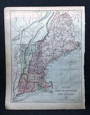
 1880 Antique Atlas Map / NEW ENGLAND
-
$123.38 CAD
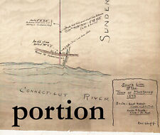 Montague-Leverett 1896 Map Town Line Survey Massachusetts - eb-108
-
$34.26 CAD
 1860 Two-Sided Original J H Colton Map Vermont/Mass/RI/Conn + NY/NJ/ PA DE
-
$16.44 CAD
 1884 McNally Map Vermont New Hampshire Concord Montpelier Mt. Washington NH VT
-
$49.30 CAD
 Vintage 1900 VERMONT Map 14"x22" ~ Old Antique Original BENNINGTON MANCHESTER VT
-
$62.99 CAD
 Old 1871 Plat Map ~ PANTON - VERGENNES PO, Townships, ADDISON County, VERMONT
-
$137.09 CAD
 Antique Colored MAP/Gray's - NEW HAMPSHIRE & VERMONT - The National Atlas 1893
-
$385.88 CAD
 Original 1867 VERMONT NEW HAMPSHIR Antique hand colored JOHNSON's MAP 26.5 X 18"
-
$61.67 CAD
 Ticonderoga, NY Topography Map, Putnam, Lake Champlain, Lake George, Crown Point
-
$29.47 CAD
 Antique 1882 Vermont/New Hampshire Map Atlas Page Hand Colored
-
$13.71 CAD
 6" x 4 1/4" Original Antique 1836 VERMONT State Map Engraved George Boynton
-
$28.35 CAD
 1938 Colorful Pictorial Map ~ VERMONT by Norman Reeves for 1939 World's Fair
-
$27.42 CAD
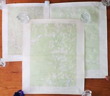
 USGS Maps 2 sizes c-z maps mostly NY, Vermont, Mass
-
$16.45 CAD
 Bomoseen VT USGS Topographic map GVC
-
$27.40 CAD
 Original 1863 Johnson Map VERMONT NEW HAMPSHIRE Burlington Concord Portsmouth
-
$17.67 CAD
 USGS Geologic Map: Rousseau Talc Prospect, Cambridge, Vermont
-
$6.85 CAD
 2 vintage USGS Topographic Maps Vermont Mt. Ellen 1971, Lincoln 1970 27"x22"
-
$15.13 CAD
 USGS Topographic Map 1983 Survey 30"x60" VT St. Johnsbury 44072-D1-TM-025
-
$15.41 CAD
 Vintage 1950 New Hampshire Vermont Highway Road Map Guide Cities Service Station
-
$24.06 CAD
 1911 Antique Vermont and New Hampshire State Map Vintage Collectible Map 533
-
$17.67 CAD
 USGS Geologic Map: Barnes Hill Talc Prospect, Vermont
-
$27.40 CAD
 1885 Cortambert Map - Eastern United States New York Florida Carolina Virginia
-
$27.42 CAD
 Dept of the Interior US Geological Survey Waitsfield Quadrangle Map VT 1970
-
$32.89 CAD
 1930 Clason Auto Road Map New England Massachusetts Connecticut Maine Vermont
-
$13.69 CAD
 1900 McNally Map - Vermont New Hampshire Concord Montpelier Mt. Washington NH VT
-
$685.43 CAD
 1840 United States antique map by Greenleaf - 14.2" x 12" scarce 1st edition
-
$38.37 CAD
 1926 Clason Auto Road Map Vermont New Hampshire Burlington Concord Montpelier
-
$28.35 CAD
 Old 1882 (Lg 15" x 21") Rand McNally Atlas Map ~ STATE of VERMONT ~ Nice Colors
-
$95.95 CAD
 Original 1869 F.W. Beers Map BELLOWS FALLS SAXTONS RIVER Vermont Windham County
-
$41.11 CAD
 Whitehall NY Topography Map Lake Champlain, Lake George, Putnam, Dresden, Benson
-
$47.98 CAD
 1909 Original 2-Sided Color Map ~ MAINE & NH / VERMONT ~ Large Map ~ Very Rare
-
$67.86 CAD
 1864 Map New Hampshire and Vermont Antique Original Hand Colored Mitchell
-
$8.23 CAD
 1897 Map North part of United States Original antique print USA
-
$82.25 CAD
 3 old original Vermont Highway Maps - 1941, 1963 & 1969 - eb-26
-
$8.91 CAD
 Map: Vermont & New Hampshire - 1910 county boundaries, railways, cities - sepia
-
$41.11 CAD
 1875 Antique COLOR Gray’s Atlas Map / NEW ENGLAND
-
$62.99 CAD
 Old 1871 Plat Map ~ LEICESTER Township, ADDISON County, VERMONT ~ Free S&H
-
$41.11 CAD
 Vermont Vintage ORIGINAL Antique State Map from Rand McNally 1899 Atlas 14x21.5
-
$38.45 CAD
 1945 Two-Sided Color Railroad Map of Virginia/Vermont Hammond 9.25x12.25"
-
$62.99 CAD
 1871 Plat Map ~ CORNWALL Township, ADDISON Co., VERMONT ~ Free S&H
-
$48.67 CAD
 1891 VERMONT MAP NEW HAMPSHIRE ANTIQUE COLOR RAILROADS MOUNTAINS VICTORIAN ERA
-
$24.68 CAD
 RARE Chittenden VT 1944 USGS Topographical Map GVC Original NOT repro
-
$102.81 CAD
 NEW HAMPSHIRE & VERMONT Antique hand colored authentic map 1857
-
$41.11 CAD
 1919 USGS Topographic Map MONTPELIER VERMONT ~15 Minute Quadrangle Topo green
-
$62.99 CAD
 Old 1871 Plat Map ~ NEW HAVEN, Township, ADDISON County, VERMONT ~ Free S&H
-
$29.49 CAD
 1890 Map NEW ENGLAND - MAINE, NEWHAMPSHIRE, VERMONT, MASSACHUSETTS -(10x12)#P290
-
$24.62 CAD
 Vintage 1903 VERMONT Map 11"x14" ~ Old Antique Original BARRE MONTPELIER VT
-
$32.90 CAD
 Lot of 3 Vintage USGS Topographic Maps Vermont 1957, 1966, '71, Series V813 GUC
-
$54.82 CAD
 1837 NICE ORIGINAL UNITED STATES BATTLE BUNKER HILL MASSACHUSETTS BOSTON
-
$39.07 CAD
 Vintage Color Map ~ New England ~ RI CONN MASS NH VERMONT MAINE Printed 1883
-
$23.30 CAD
 1891 VERMONT Map, Color Counties, Historical Points, 14" x 10.5"
-
$34.49 CAD
 Vintage 1901 VERMONT Map 11"x14" ~ Old Antique Original BARRE MONTPELIER NEWPORT
-
$33.50 CAD
 Vintage 1901 VERMONT Map 11"x14" Old Antique Original BARRE MONTPELIER NEWPORT
-
$116.52 CAD
 1876 North Eastern States antique map ~ 27.3" x 19.6" hand colored NY MD PA ME+
-
$41.11 CAD
 1852 Antique Atlas Map / NEW ENGLAND, or, EASTERN STATES
-
$27.42 CAD
 USGS Topographic Map New York Vermont - WILLSBORO BAY - 1980 - 25K - NY VT
-
$41.11 CAD
 Original 1869 Map GUILFORD GREEN RIVER VILLAGE HINESBURG Vermont Windham County
-
$21.87 CAD
 Virginia State Detailed Antique Map Original Clean 1908 C.S. Hammond
-
$39.59 CAD
 VERMONT Map 1912 ORIGINAL Counties Population Montpelier Sand Gate Vintage
-
$15.13 CAD
 USGS Topographic Map 1984 Survey 30"x60" NH, VT Winchester 42072-G3-TM-025
-
$78.81 CAD
 1850 ORIGINAL MAP UNITED STATES NEW YORK MASSACHUSETTS CONNECTICUT VERMONT MAINE
-
$82.25 CAD
 1886 Tunison Map United States Indian Territory Oklahoma Dakota Texas California
-
$171.36 CAD
 1830 Pacific Ocean - islands coasts & US antique map by Huntington ~ 11" x 8.25"
-
$62.99 CAD
 Old 1871 Plat Map ~ SALISBURY Township, ADDISON County, VERMONT ~ Free S&H
-
$29.56 CAD
 Vintage 1902 VERMONT Map 11"x14" ~ Old Antique Original BRISTOL MIDDLEBURY VT
-
$38.44 CAD
 Vintage 1901 VERMONT Map 14"x22" ~ Old Antique Original MONTPELIER WOODSTOCK VT
-
$62.99 CAD
 1871 Plat Map ~ SALISBURY, LEICESTER, HANCOCK Townships, ADDISON Co., VERMONT
-
$38.38 CAD
 1919 Auto Road Map Vermont New Hampshire Burlington Concord Mt. Washington VT NH
-
$54.82 CAD
 1830 Nathan Hale Map - Vermont - Montpelier Woodstock Rockingham Lake Champlain
-
$28.35 CAD
 Old Antique 1904 Cram's Atlas Map ~ VERMONT ~ Free S&H ~ Inv#2
-
$41.11 CAD
 1849 Mitchell's Map New England States 17x11 Maine VT NH MA RI CT Antique Atlas
-
$27.40 CAD
 1876 Antique COLOR Atlas Map / MAINE, NEW HAMPSHIRE, VERMONT
-
$16.44 CAD
 1942 Hammond Railroad Map Vermont Montpelier Rutland Concord Burlington RR
-
$13.69 CAD
 1908 Rand McNally Map - Vermont - Montpelier Burlington Rutland Lake Champlain
-
$62.99 CAD
 Old 1871 Plat Map ~ BRISTOL, ADDISON County, VERMONT ~ Free S&H
-
$20.56 CAD
 1884 New England States USA Harper and Brothers Copyright 1875 Map Ephemera
-
$61.67 CAD
 Map Keene NH Vermont 1958 Topographic Geo Survey 1:62500 22 x 18" TOPO3
-
$34.26 CAD
 NY VT Hoosick Topography Map Cambridge, Pittstown, Grafton, Petersburg, White Cr


