 Antiques (CA)
-
$86.99 CAD

 Original 1864 MASS CONN Rhode isl Antique hand colored JOHNSON's MAP 26.5 X 18"
-
$109.65 CAD
 1879 Map New England USA Victorian Atlas Harpers Geography 1st Edition DWAA9
-
$20.91 CAD
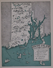
 1940s Antique RHODE ISLAND State Map Vintage Picture Map of Rhode Island 1524
-
$71.96 CAD
 Map Oxford Massachusetts CT RI USGS 1979 Topographic Geo 1:24000 27x22" 2 TOPO12
-
$24.68 CAD
 Massachusetts, Connecticut & Rhode Island - Original 1882 Map by Phillips & Hunt
-
$23.30 CAD
 Connecticut & Rhode Island - Original 1902 Map by The Century Company, Antique
-
$35.57 CAD
 Rand-McNally regional state map: EASTERN UNITED STATES © 2004 - paper
-
$24.68 CAD
 1953 VINTAGE MAP OF MARYLAND DELAWARE WASHINGTON D.C. VERSO MASSACHUSETTS BOSTON
-
$27.68 CAD
 1943 VINTAGE WWII MAP OF MARYLAND DELAWARE / MASSACHUSETTS RHODE ISLAND
-
$17.82 CAD
 1943 Vintage Map - The Thirteen Colonies - New York City Boston Charleston
-
$34.13 CAD
 1878 Eastern UNITED STATES Vintage MAP New York Maine NJ ORIG 11.5 x 9.5 C17-3
-
$62.99 CAD
 1882 Plat Map ~ ROGER WILLIAMS PARK, PROVIDENCE, RHODE ISLAND #19 (XL18x28)
-
$71.28 CAD
 1830 Nathan Hale Map Connecticut Hartford New Haven London Norwalk Greenwich CT
-
$82.24 CAD
 Map Oxford Massachusetts CT RI USGS 1979 Topographic Geo 1:24000 27x22" TOPO12
-
$61.67 CAD
 Map Uxbridge Massachusetts RI USGS 1979 Topographic Geo 1:24000 27x22" TOPO12
-
$61.67 CAD
 Map Oxford Massachusetts CT RI USGS 1979 Topographic Geo 1:24000 27x22" 3 TOPO12
-
$137.09 CAD
 Bill Turner Double Sided Original Map Of Smithfield Rhode Island 1965 History
-
$76.08 CAD
 Original 1800's Newport,Rhode Island City Map
-
$13.69 CAD
 1917 McNally Map - Rhode Island Providence Connecticut New Haven Hartford Mystic
-
$27.40 CAD
 1883 Antique Map / STATE OF RHODE ISLAND / 10.5x14.5 inches
-
$24.17 CAD
 Antique 1862 Lincoln-was-president color map Mass. Conn. R.I. Mitchell Jr 1860s
-
$23.30 CAD
 1891 RHODE ISLAND Map, Color Counties, Historical Points, 14" x 10.5"
-
$28.35 CAD
 Vintage 1907 Railroad & County Map ~ RHODE ISLAND ~ Old Authentic ~ Free S&H
-
$38.37 CAD
 1830 Nathan Hale Map Rhode Island Providence Newport Greenwich Watch Hill Canal
-
$43.85 CAD
 1830 Nathan Hale Map - Rhode Island - Providence Newport Greenwich Bristol - RI
-
$34.26 CAD
 1883 Antique Atlas Map / RHODE ISLAND
-
$34.26 CAD
 1880 Antique Atlas Map / NEW ENGLAND
-
$17.82 CAD
 1943 Vintage Map - The United States on March 4, 1861 - The Civil War
-
$104.17 CAD
 1873 Mitchell's Map of Massachusetts, CT, R.I., Authentic Hand-Colored Antique
-
$27.35 CAD
 1886 Original Antique Mitchell Map: NJ NY PA DE on reverse MA CT RI
-
$54.82 CAD
 Map Mass RI CT Index Chart Geological Topographic Survey 1984 51 x 32" DWX6A
-
$61.67 CAD
 Map Blackstone Massachusetts RI USGS 1979 Topographic Geo 1:24000 27x22" TOPO12
-
$62.99 CAD
 1882 Plat Atlas Map ~ Part of WARWICK, RHODE ISLAND -#44 (14x18)
-
$27.14 CAD
 1903 MASSACHUSETTS RHODE ISLAND Map 22"x14" ~ Old Antique Original FALL RIVER MA
-
$30.23 CAD
 1904 Antique PROVIDENCE Street Map City Map of Providence Rhode Island 1608
-
$23.63 CAD
 Vintage 1901 RHODE ISLAND Map 11"x14" Old Antique Original PROVIDENCE CRANSTON
-
$32.89 CAD
 1930 Clason Auto Road Map New England Massachusetts Connecticut Maine Vermont
-
$24.68 CAD
 1911 McNally Index Map - Rhode Island Providence Bristol Woonsocket Kingston RI
-
$41.11 CAD
 Map Webster Mass CT RI Geological Topographic Survey 1982 24 x 38" DWX6A
-
$24.06 CAD
 1894 Antique MASSACHUSETTS State Map George Cram Map of RHODE ISLAND 9670
-
$685.43 CAD
 1840 United States antique map by Greenleaf - 14.2" x 12" scarce 1st edition
-
$17.75 CAD
 1911 Antique Rand McNally Map of CONNECTICUT & RHODE ISLAND & State Demographics
-
$28.35 CAD
 Vintage 1950 Atlas Map ~ RHODE ISLAND - NEWPORT ~ Old & Authentic ~ Free S&H
-
$16.45 CAD
 Connecticut & Rhode Island - Original 1902 Map by The Century Co. RI Antique
-
$28.35 CAD
 1897 Century Atlas Map ~ CONNECTICUT - RHODE ISLAND ~(12x18) ~ Free S&H #242
-
$28.35 CAD
 Old (Large 17"x23") 1889 Cram's Atlas Railroad Map ~ MASSACHUSETTS RHODE ISLAND
-
$16.44 CAD
 1884 McNally Map Connecticut Rhode Island Providence New Haven Newport Mystic
-
$28.35 CAD
 Old 1896 Fisk & Co. Atlas Map ~ MASSACHUSETTS CONNECTICUT RI ~(11x14) ~#232
-
$13.69 CAD
 1958 McNally Map - Rhode Island - Providence Newport Narrangansett Bay Warwick
-
$27.42 CAD
 Connecticut & Rhode Island - Original 1902 Map by The Century Co. RI Antique
-
$10.97 CAD
 Map 1901 Rhode Island / Boston
-
$21.93 CAD
 1885 McNally Map Connecticut Rhode Island New Haven Hartford Providence Newport
-
$17.81 CAD
 Antique 1914 World War WWI Old Atlas City Map Providence, Rhode Island, RI L@@K!
-
$20.56 CAD
 Providence, Rhode Island....Antique Map, Plan..1892
-
$62.99 CAD
 1882 Plat Map 10 MILE RIVER, HAMMONDS POND, PROVIDENCE, RHODE ISLAND #28 (18x28)
-
$41.11 CAD
 1875 Antique COLOR Gray’s Atlas Map / NEW ENGLAND
-
$21.92 CAD
 1857 Morse Map - Connecticut Rhode Island Long New York Haven Newport Providence
-
$16.45 CAD
 1899 c. Rhode Island Rand McNally Original Standard World Atlas Map
-
$8.21 CAD
 L@@K! Vintage 1940 World Atlas Map Rhode Island & South Carolina WWII Providence
-
$29.49 CAD
 1890 Map NEW ENGLAND - MAINE, NEWHAMPSHIRE, VERMONT, MASSACHUSETTS -(10x12)#P290
-
$137.09 CAD
 1847 Williams Map New England Massachusetts Connecticut Rhode Island Boston RR
-
$54.82 CAD
 1837 NICE ORIGINAL UNITED STATES BATTLE BUNKER HILL MASSACHUSETTS BOSTON
-
$28.35 CAD
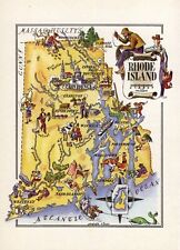
 1959 Picture / Pictorial Map Geography of RHODE ISLAND - PS JOHST - VERNON QUINN
-
$39.07 CAD
 Vintage Color Map ~ New England ~ RI CONN MASS NH VERMONT MAINE Printed 1883
-
$62.99 CAD
 1882 Plat Map ~ MOUNT PLEASANT, PROVIDENCE, RHODE ISLAND #13 (XL18x28)
-
$116.52 CAD
 1876 North Eastern States antique map ~ 27.3" x 19.6" hand colored NY MD PA ME+
-
$41.11 CAD
 1852 Antique Atlas Map / NEW ENGLAND, or, EASTERN STATES
-
$185.06 CAD
 1895 WARWICK, RI., MAP REMOVED FROM THE EVERTS & RICHARDS ATLAS OF 1895
-
$78.81 CAD
 1850 ORIGINAL MAP UNITED STATES NEW YORK MASSACHUSETTS CONNECTICUT VERMONT MAINE
-
$27.40 CAD
 1897 State Map MASSACHUSETTS & R.I. 22" X 13.75" ~ Reverse LOWELL, MT WASHINGTON
-
$13.69 CAD
 CRAM'S ATLAS MAP PAGE STATE OF CONNECTICUT & RHODE ISLAND 1899 VINTAGE
-
$24.06 CAD
 CT RI Lg 1901 CONNECTICUT, RHODE ISLAND RAILROAD Map McN Business. Full Index
-
$34.38 CAD
 Vintage 1902 MASSACHUSETTS RHODE ISLAND Map 22"x14" Old Antique Original BOSTON
-
$62.99 CAD
 1882 Plat Atlas Map PROVIDENCE, RHODE ISLAND - Portion of WARD 10 - #5 (14x18)
-
$137.09 CAD
 Bill Turner Double Sided Original Map Of Glocester Rhode Island 1965 History
-
$32.89 CAD
 1919 Auto Road Map Connecticut Rhode Island Hartford New Haven Providence CT RI
-
$41.11 CAD
 1849 Mitchell's Map New England States 17x11 Maine VT NH MA RI CT Antique Atlas
-
$15.13 CAD
 USGS Topographic Map 1984 Survey 30"x60" RI, MA Providence 41071-E1-TM-100
-
$82.18 CAD
 Antique 1883 Rhode Island Atlas ~ James Monteith Educational Map
-
$15.42 CAD
 USGS Topographic Map PROVIDENCE Rhode Island/MA 1987 1:25000 scale folded map
-
$31.97 CAD
 Vintage 1902 MASSACHUSETTS RHODE ISLAND Map 22"x14" Old Antique Original BOSTON
-
$28.35 CAD
 1856 Cowperthwait Atlas Map MASSACHUSETTS, CONNECTICUT, RHODE ISLAND (9x11) #175
-
$20.56 CAD
 1884 New England States USA Harper and Brothers Copyright 1875 Map Ephemera
-
$29.56 CAD
 Vintage 1903 MASSACHUSETTS RHODE ISLAND Map 22"x14" Old Antique Original BRISTOL
-
$13.69 CAD
 CRAM'S ATLAS MAP PAGE MASSACHUSETTS RHODE ISLAND VERMON NH 1899 VINTAGE
-
$185.06 CAD
 1895 WICKFORD & LaFAYETTE, RI., MAP REMOVED FROM EVERTS & RICHARDS ATLAS OF 1895
-
$32.08 CAD
 Vintage 1901 MASSACHUSETTS RHODE ISLAND Map 22"x14" Old Antique Original BRISTOL
-
$62.99 CAD
 1882 Plat Map ~ PAWTUCKET - MINERAL SPRING CEMETERY, PROVIDENCE, RI #31 (18x28)
-
$34.49 CAD
 1901 MASSACHUSETTS RHODE ISLAND Map 22"x14" ~ Old Antique Original WORCESTER MA
-
$34.27 CAD
 1901 Tunison New York NYC & Long Island antique map ~ 23" x 14.6" - nice color
-
$62.99 CAD
 1882 Plat Map ~ GENEVA & WANSKUCK, PROVIDENCE, RHODE ISLAND #11 (XL18x28)
-
$67.86 CAD
 1864 Map Massachusetts Connecticut Rhode island Antique Original Hand Colored
-
$39.43 CAD
 Vintage 1900 MASSACHUSETTS RHODE ISLAND Map 22"x14" Old Antique Original BOSTON
-
$27.35 CAD
 CENTURY ATLAS MAP PLATE #10 CONNECTICUT RHODE ISLAND NEWPORT RI USA 1911 ANTIQUE
-
$62.99 CAD
 1882 Plat Map ~ NORTH BURIAL GROUND - PROVIDENCE, RHODE ISLAND #10 (XL18x28)
-
$62.99 CAD
 1882 Plat Atlas Map ~ BROWN UNIVERSITY - PROVIDENCE, RHODE ISLAND -#2 (XL18x28)
-
$28.35 CAD
 Old 1931 Pictorial Map ~ RHODE ISLAND by P.S. JOHST ~ Free S&H
-
$54.82 CAD
 1869 Chambers Map East United States New York Florida Virginia Missouri Michigan
-
$54.82 CAD
 1879 Map Rhode Island United States Victorian Geography 1st Edition DWAA9
-
$47.98 CAD
 Antique County Map of Massachusetts, Connecticut & Rhode Island, 1880, 23"x15"


