 Antiques (CA)
-
$410.56 CAD

 1860 U.S.C.S.Nautical Chart MONOMOY NANTUCKET SHOAL BLOCK ISLAND-1874 CORRECTION
-
$20.56 CAD
 US COAST SURVEY MAP 1854 Washington Smith's Island
-
$548.34 CAD
 Original 1855 Coast Survey Chart North Carolina Albemarle Sound Hand Colored
-
$102.81 CAD
 1960 Vintage Nautical Map Atlantic City to Cape May NJ Shore C.&G.S. 38”x24
-
$68.54 CAD
 1945 A Sailor's map of Nantucket rare original
-
$54.82 CAD
 1853 Gunnison Survey Map FOR NEW CHANNEL FROM MILWAUKEE RIVER TO LAKE MICHIGAN
-
$68.53 CAD
 1854 Gloucester Cape Ann American Coast Pilot Massachusetts MA USA Antique Map
-
$678.57 CAD
 1916 antique ELDRIDGE MAP linen backed GLOUCESTER to KENNEBEC RIVER 24.5"x67"
-
$34.26 CAD
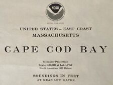 1977 Sea Chart Cape Cod Massachusetts USA Vintage Original Map Coastal Sailing
-
$24.37 CAD
 Vintage 1929 Coast Guard Nautical Map Galveston to Mississippi River 36 x 44"
-
$20.49 CAD
 1851 U S Coast Survey Map,Sandy Hook,NJ,1779-1851,Coves,Lighthouse,changes,Head
-
$342.71 CAD
 Original 1851 Coast Survey Chart North Carolina Outer Banks
-
$27.35 CAD
 1851 US Coast Survey Map,Point Pinos,Monterey Bay,Califirnia,proposed Lighthouse
-
$1089.83 CAD
 1891 antique full Set of 14 USA lighthouse district Maps charts nautical
-
$27.42 CAD
 Newport California Chart #5108 1967 10th Ed
-
$34.27 CAD
 2 Antique maps 1907 Chesapeake Md shellfish coast survey Somerset Wicomico
-
$95.95 CAD
 Original 1863 Coast Survey Chart Map ROCKLAND HARBOR & VICINITY Maine Lighthouse
-
$20.55 CAD
 Nautical Map of West End of Lake Erie for traning purpose only
-
$50.04 CAD
 1967 FLORIDA AND BAHAMAS Operational Nav Chart HUGE Map ONC H-25 - 41"x57"
-
$68.53 CAD
 Original 1853 Coast Survey Soundings Map HORN ISLAND PASS Pascagoula Mississippi
-
$68.53 CAD
 Original 1861 Coast Survey Shipwreck Map COOS BAY Oregon Soundings Tide Table
-
$10.95 CAD
 Vtg NOAA US Great Lakes & Adjacent Waterways Nautical Chart July 1986 Catalog 4
-
$13.71 CAD
 Fishing N Recreational Map Of Chincoteague N Assateague
-
$41.06 CAD
 1851 US Coast Survey Map of Mouth of Columbia,California,soundings,other rivers
-
$27.42 CAD
 Lot Of 3 Lake Michigan Maps NOAA Charts
-
$41.13 CAD
 Vintage - NOAA 1993 35th Ed Nautical Map - Approaches to New York 12300 Unfolded
-
$38.38 CAD
 Vintage Nautical Marine Map New York Harbor 1970s. Sam Epstein original owner
-
$95.95 CAD
 Original 1853 Coast Survey Map PUNGOTEAGUE CREEK Chesapeake Bay Virginia Wharf
-
$28.79 CAD
 Vintage 1992 Natical Chart Map Of New York, Lake Ontario, Mexico Bay, North Pond
-
$163.13 CAD
 Vintage Tampa Bay And St. Joseph Sound NOAA 1972 Nautical Map Number 1257
-
$27.42 CAD
 OLD South West Pacific Mercators Projection Map Librairie Pentecost Noumea 1900s
-
$54.82 CAD
 Original 1853 Coast Survey Soundings Map CORTES BANK California Channel Islands
-
$68.53 CAD
 Original 1861 Coast Survey Map COQUILLE RIVER Oregon Pacific Ocean Compass Rose
-
$54.82 CAD
 1854 Annis Squam Ipswich Bay American Coast Pilot Massachusetts USA Antique Map
-
$34.26 CAD
 Original 1881 Survey Map MOUTH OF THE COLUMBIA RIVER Oregon Soundings Breakers
-
$68.53 CAD
 1854 Chesapeake Bay American Coast Pilot Maryland MD Virginia VA USA Antique Map
-
$34.27 CAD
 C&GS Coastal Map #557 Potomac River Chesapeake Bay To Piney Point 1973 18th Ed.
-
$95.95 CAD
 Original 1863 US Coast Survey Map HALF MOON BAY California Whaling Stations
-
$102.80 CAD
 1854 Boston Harbor American Coast Pilot Massachusetts MA USA Antique Map
-
$9938.67 CAD
 Original 1848 Blunt Blueback Nautical Chart US East Coast Block Island to Cuba
-
$75.40 CAD
 Geo.Eldridge detailed nautical chart. Bridgeport Connecticut 1901. Hand Colored
-
$34.27 CAD
 1960s Lake Erie Educational Map For Training Purposes Only
-
$54.67 CAD
 San Francisco Bay Waterproof Chart, 3rd Edition
-
$102.81 CAD
 Vintage SEACRAFT MAP Framed Glass Tray San Juan Islands Brass Cleat Handles
-
$16.38 CAD
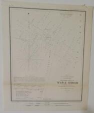 1854 U S Coast Survey Map,Chart, Turtle Harbor, Florida Reefs,Sailing Directions
-
$68.53 CAD
 1854 Isles Of Shoals American Coast Pilot Maine ME New Hampshire NH Antique Map
-
$43.18 CAD
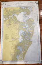
 Original NOAA 1975 14th Ed Nautical Map GULF OF MAINE & GEORGES BANK Cape Cod
-
$20.49 CAD
 1851 U S Coast Survey Map E,2,Savannah,River,Islands,survey progress lines,scale
-
$34.26 CAD
 1976 Nautical Chart East River New York USA Vintage Map Sailing Coastal Sea
-
$47.98 CAD
 Charleston Harbor, South Carolina 1888
-
$17.75 CAD
 1851 U S Coast Survey Map,Savannah & 2 Rivers,Approaches,Islands,Soundings,Tides
-
$27.35 CAD
 1851 U S Coast Survey Map,LI to Cape Henlopen,CT & NJ Coasts,Bays,Sounds,Inlets
-
$16.38 CAD
 1854 U S Coast Survey Map,Chart of Coffin's Patches,Florida Reefs, Bottom Depths
-
$47.98 CAD
 1853 Little Sodus Bay US coast Survey map Cayuga New York 19"x 15" Nautical
-
$82.25 CAD
 1856 US coast Survey map Lousiana, Mississippi, Alabama - 34.5" x 23" Nautical
-
$176.84 CAD
 SALE! GENUINE ANTIQUE 1893 color lithographed map East End LONG ISLAND NEW YORK
-
$20.55 CAD
 Original 1882 Barlow Survey Map BRIDGEPORT HARBOR Connecticut Lighthouse Beacons
-
$19.19 CAD
 1960s battles of the Civil War Facsimile printed on Parchment like paper
-
$68.53 CAD
 Rare 1850 John Gavit Engraving - New York Fort la Présentation anno 1749
-
$54.82 CAD
 Oceangrafix 2011 Nautical Chart 11329 Map of Houston Shipping Channel 35"X32"
-
$34.27 CAD
 1960s Martha's Vinyard Educational Map For Training Purposes Only
-
$12.32 CAD
 Vintage ANDERSON ISLAND WA Coastal Zone Atlas of Washington Subtidal Clam Map
-
$68.53 CAD
 1854 Newburyport Harbour American Coast Pilot Massachusetts USA Antique Map
-
$108.30 CAD
 GENUINE ANTIQUE 1893 color lithographed map CAPE CHARLES VIRGINIA VA
-
$54.82 CAD
 Oceangrafix 2012 Nautical Chart 11339 Map Calcasieu River Lake Charles 34"X55"
-
$205.63 CAD
 Bristol Harbor R.I. 1864 Coast Survey Antique Map Topography and Navigation
-
$54.82 CAD
 Oceangrafix 2011 Nautical Chart 11326 Map of Galveston Bay Texas 39"X55"
-
$54.83 CAD
 Cedar Keys Florida Coast 1861 U.S. Coast Survey map. Note Tear In Left 1/3
-
$493.49 CAD
 Original 1793 Map NORTH PACIFIC Explorations Capt Cook Clerke Hearne Hudson Bay
-
$116.52 CAD
 Vintage 1967 Map NEW YORK CITY EAST RIVER, Tallman Island to Queensboro Bridge
-
$205.61 CAD
 Original John Maffitt 1852 Coast Survey Map NEW RIVER INLET & BAR North Carolina
-
$479.80 CAD
 1837 Folding Chart of George’s Shoal & Bank, Surveyed by Charles Wilkes, US Navy
-
$205.61 CAD
 Original 1873 Coast Survey Map OREGON WASHINGTON "Tillamook Bay to the Boundary"
-
$137.07 CAD
 1928 Costal Color Tidal Current Chart,New York Harbor Staten Coney Long Island
-
$80.88 CAD
 GENUINE ANTIQUE 1893 color lithographed map LAGOON HARBOR CAPE CANAVERAL FLORIDA
-
$14.39 CAD
 Waterproof Chart Barrier Islands Boca Grande to Estero Bay Chart #25E SEALED NEW
-
$27.40 CAD
 1962 Matha's Vineyard to Block Island Nautical Map #1210 Anchorage Areas 49"
-
$47.98 CAD
 Index Map of Fenwick's Island, South Carolina 1887
-
$64.36 CAD
 Coast Chart No. 8 Wells to Cape Ann 1867 US Coast Survey
-
$137.09 CAD
 1936 5 map set Inland waterway New York to Key West, Coast & Geodetic Survey
-
$53.46 CAD
 GENUINE ANTIQUE 1893 color lithographed map MARQUESAS KEYS FLORIDA
-
$61.69 CAD
 GENUINE ANTIQUE 1893 color LITHOGRAPHIC map of part of MAINE coast YARMOUTH
-
$149.42 CAD
 GENUINE ANTIQUE 1893 color lithographed map PROVINCETOWN HARBOR MASSACHUSETTS MA
-
$34.27 CAD
 1926 antique map Karluk Lake kodiak Alaska Willis Rich fishing
-
$130.23 CAD
 GENUINE ANTIQUE 1893 color lithographed map MOUTH OF THE MISSISSIPPI RIVER
-
$217.97 CAD
 GENUINE ANTIQUE 1893 color lithographed map SAVANNAH DISTRICT HILTON HEAD SC
-
$8.23 CAD
 Vintage QUIMPER PENINSULA WA Coastal Zone Atlas of Washington Subtidal Clam Map
-
$137.09 CAD
 1902 antique map nautical chart Alaska lighthouses gold crab
-
$75.33 CAD
 1863 US Coast Survey Cape Florida to Tortuga Islands Map Chart
-
$342.71 CAD
 RARE Antique CARL FLEMMINGS GENERALKARTEN No.40 US, NORD-AMERICA,CUBA,PR, Map
-
$8.23 CAD
 Vintage MAURY ISLAND WA Coastal Zone Atlas of Washington Subtidal Clam Map
-
$12.32 CAD
 Vintage ISLAND COUNTY WA Coastal Zone Atlas of Washington Subtidal Clam Map
-
$8.23 CAD
 Vintage PORT DISCOVERY WA Coastal Zone Atlas of Washington Subtidal Clam Map
-
$102.81 CAD
 1897 Guadalupe island California US coast survey antique map white sharks
-
$8.23 CAD
 Vintage KITSAP COUNTY WA Coastal Zone Atlas of Washington Subtidal Clam Map
-
$12.32 CAD
 Vintage BUDD INLET OLYMPIA WA Coastal Zone Atlas of Washington Subtidal Clam Map
-
$185.06 CAD
 GENUINE ANTIQUE 1893 color lithographed map North CAROLINA HARBORS cape Fear
-
$12.32 CAD
 Vintage KITSAP COUNTY WA Coastal Zone Atlas of Washington Subtidal Clam Map
-
$12.32 CAD
 Vintage CLALLAM COUNTY WA Coastal Zone Atlas of Washington Subtidal Clam Map
-
$8.23 CAD
 Vintage SEABECK KINGSTON WA Coastal Zone Atlas of Washington Subtidal Clam Map


