 Antiques (CA)
-
$57.58 CAD

 Antique Glacier National Park, Montana 1942 USGS topographic map 35"x31"
-
$397.53 CAD
 Western US Map - Home & Cabin Decor Map - Shaded Relief Map
-
$27.76 CAD
 1950s Vintage Montana State Map Animated Montana Picture Map Wall Decor BW 1095
-
$274.16 CAD
 Territory Of The Northern Plains Tribes Framed
-
$17.67 CAD
 USGS Geologic Map: Tepee Creek Quadrangle, Montana - Wyoming
-
$3084.41 CAD
 1921 USGS Copper Printing Map Plates Drummond , MT set of 3 Topographic Survey
-
$65.80 CAD
 1855 Montana Rocky Mountains ORIGINAL LITHOGRAPH Lewis Clark Pass RARE
-
$64.27 CAD
 1855 Montana Native Americans Gov Stevens LITHOGRAPH ORIGINAL Washington Terr.
-
$40.34 CAD
 1927 MAP OF NW USA WASHINGTON SEATTLE OREGON IDAHO BRITISH COLUMBIA VANCOUVER
-
$24.68 CAD
 1953 VINTAGE MAP OF MONTANA / VERSO NEBRASKA
-
$47.98 CAD
 Rand-McNally city map: Butte Helena Great Falls Anaconda Montana ©1991 -Index-
-
$17.75 CAD
 Vintage MONTANA FORESTRY MAP LOT Deerlodge Gallatin Custer Interagency Philipsbg
-
$27.33 CAD
 Antique 1890s Montana Idaho Wyoming Color Map Atlas Page
-
$27.40 CAD
 Vtg Ravalli County Montana Road Index Map Collection FIRST EDITION Large 24"x18"
-
$17.82 CAD
 Red Lodge Mont Wyoming 1944 Original Vintage USGS Topo Map 15 Minute Quadrangle
-
$2398.99 CAD
 THREE 1886 USGS ANTIQUE COPPER MAP PRINTING PLATES 1:250,000 GREAT FALLS MT
-
$65.80 CAD
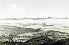
 1855 Eastern Montana Missouri River Basin ORIGINAL LITHOGRAPH Landscape View
-
$8.23 CAD
 1897 Map of United States & Mexico Original antique print
-
$43.85 CAD
 1919 Auto Road Map Montana Billings Helena Missoula Bozeman Butte Yellowstone NP
-
$51.93 CAD
 1855 Montana Gros Ventres Indians LITHOGRAPH ORIGINAL Native Americans
-
$52.09 CAD
 1855 Cadotte's Pass Montana Rocky Mountains ORIGINAL LITHOGRAPH Landscape View
-
$10.97 CAD
 1952 Montana Official State Highway Comission Road Map
-
$40.34 CAD
 1927 MAP OF CENTRAL USA MONTANA WYOMING YELLOWSTONE NORTH SOUTH DAKOTA NEBRASKA
-
$8.23 CAD
 1897 Map Western part of United States Original antique print USA
-
$27.40 CAD
 Canvas Reproduction Vintage Pictorial Map of Montana Print Ruth Taylor 1935
-
$17.67 CAD
 USGS Geologic Map: Tepee Creek Quadrangle, Montana, Wyoming
-
$36.74 CAD
 Original 1894 Antique Map MONTANA Belgrade Lewis Lolo Columbia Great Falls Libby
-
$239.90 CAD
 1875 Map Yellowstone Montana Captain William Ludlow US Army Corps Engineers
-
$41.17 CAD
 1898 Map of the State of MONTANA Hand Colored Lithograph 10.75 x 7.25
-
$178.20 CAD
 1903 Map Absaroka Division of Yellowstone Forest Reserve Montana See description
-
$4.73 CAD
 Upper Missouri National Wild & Scenic River Maps 3 & 4, Dept Of The Interior.
-
$17.75 CAD
 1909 Original Map South Dakota rev. Montana:showing Native-American Reservations
-
$68.53 CAD
 Large Format 1905 COLOR Rand McNally Map Atlas Page 239 Railroads Montana
-
$8.23 CAD
 1897 Map East part of United States Original antique print
-
$54.82 CAD
 1926 Clason Auto Road Map Montana Billings Bozeman Helena Glacier Yellowstone NP
-
$135.71 CAD
 1878 Colorado Montana Dakota & Wyoming Mitchell antique map 22.9" x 15.1"
-
$15.90 CAD
 USGS Geologic Map: West Yellowstone Quadrangle, Montana, Wyoming, Idaho
-
$8.21 CAD
 L@@K! Vintage 1943 World Atlas Color Map of Montana & Missouri WWII Nice Map OLD
-
$13.71 CAD
 22x29 Vintage 1915 USGS Topo Map Tule Valley, Montana Fort Peck Indian Res.
-
$22.15 CAD
 1941 Antique MONTANA MAP Vintage State Map of Montana Gallery Wall Art 246
-
$15.90 CAD
 USGS Geological Survey Map: Montana Custer Battlefield 1891 - Reprint
-
$171.36 CAD
 1883 General Sherman Route Map Fort Ellis Montana to Fort Hope British Columbia
-
$99.11 CAD
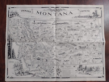 Vintage 1937 MONTANA Pictorial Map by IRVIN SHOPE Frontier Pioneer History Art
-
$29.82 CAD
 USGS Topographic Map SWEET GRASS HILLS Montana USA Alberta Canada -1984- 100K
-
$17.82 CAD
 Miner Montana 1955 Original Vintage USGS Topo Map 15 Minute Quadrangle
-
$30.09 CAD
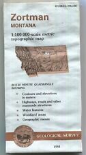 USGS Topographic Map ZORTMAN Montana 1984 47108-E1-TM-100 WD Bad
-
$53.46 CAD
 1878 Western Hemisphere Mitchell antique map 15.1" x 12.1" - nice color
-
$13.71 CAD
 Vtg 1954 Montana Resources Products Economic Illustrated Map Hammond Doubleday
-
$68.54 CAD
 1864 Dakota Montana Nebraska Kansas CO by Johnson Ward antique map 17.3" x 13.8"
-
$28.35 CAD
 1938 Colorful Pictorial Map MONTANA by Norman Reeves for 1939 World's Fair
-
$53.46 CAD
 1878 Oregon Washington MT ID Mitchell antique map 15.1" x 12.3" - nice color
-
$52.09 CAD
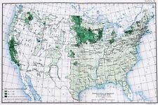 OLD 1900 United States Map ORIGINAL LARGE Farming Agriculture Barley Grain
-
$41.06 CAD
 1879 Original Engraved color MAP OF WESTERN STATES AND TERRITORIES new 11x14 mat
-
$16.44 CAD
 1900 McNally Map Montana Idaho Billings Helena Butte Boise Bitter Root Mountains
-
$23.30 CAD
 1893 MONTANA Map, Color Counties, Historical Points, 14" x 10.5"
-
$32.90 CAD
 USGS BLM edition topographic map Montana PLAINS 2002
-
$33.24 CAD
 USGS BLM edition topographic map Montana BOZEMAN 1993 mineral
-
$9.60 CAD
 1951 Montana Official State Highway Comission Road Map
-
$23.25 CAD
 Map Gallatin National Forest Montana Principal and Boise Meridians 1984 (1991)
-
$54.83 CAD
 Original 1955 Montana Geological Map, Sect.of the Interior. 48" Square Excellent
-
$62.99 CAD
 1892 Cram's Atlas Railroad Map ~ MONTANA ~ (XLG17x25) -#399
-
$48.67 CAD
 1891 MONTANA MAP WYOMING IDAHO ANTIQUE FULL COLOR RAILROADS RIVERS MOUNTAINS VTG
-
$17.67 CAD
 USGS Geologic Map: Mammoth, Part of Gardiner Quadrangle, Wyoming, Montana
-
$17.82 CAD
 Mount Holmes Mont Wyo 1958 Original Vintage USGS Topo Map 15 Minute Quadrangle
-
$15.90 CAD
 USGS Geologic Map: Northern Part of Ruby Range, Montana
-
$52.98 CAD
 USDA National Forest Service Map SELWAY BITTEROOT Wilderness Idaho Montana 1989
-
$23.25 CAD
 Map LOLO National Forest Montana Principal and Boise Meridians 1991 (1994) USDA
-
$17.67 CAD
 USGS Geologic Map: Upper Red Rock Lake Quad, Southwestern Montana, Idaho
-
$178.20 CAD
 Original 1874 Mitchell Map WASHINGTON OREGON IDAHO TRAIL Wagon Roads Gold Mines
-
$17.82 CAD
 Hebgen Dam Montana 1950 Original Vintage USGS Topo Map 15 Minute Quadrangle
-
$34.26 CAD
 1893 MONTANA Map w/ Colored Counties, Reverse NORTH DAKOTA, Dated, 14" x 10.5"
-
$64.10 CAD
 Vintage 1900 YELLOWSTONE PARK Map 11"x14" ~ Antique Original OLD FAITHFUL GEYSER
-
$46.10 CAD
 USDA National Forest Service Map BITTERROOT Montana Idaho 1981
-
$28.35 CAD
 Old 1906 Atlas Map ~ MONTANA ~ Free S&H
-
$61.69 CAD
 USGS Topographic Map YELLOWSTONE NATIONAL PARK NORTH Wyoming Montana 1983 -100K-
-
$17.67 CAD
 Tectonic Map of the Fold and Thrust Belt, West-Central Montana
-
$17.82 CAD
 Garnet Mountain Montana 1955 Original Vintage USGS Topo Map 15 Minute Quadrangle
-
$17.82 CAD
 West Yellowstone Montana 1958 Original Vintage USGS Topo Map 15 Min Quadrangle
-
$12.32 CAD
 USGS Geologic Map: Vaughn Quadrangle, Montana
-
$17.82 CAD
 Sphinx Mountain Montana 1950 Original Vintage USGS Topo Map 15 Minute Quadrangl
-
$17.67 CAD
 Geologic Map: Drummond Area, Central-Western Montana
-
$95.95 CAD
 Lot 7 Survey Maps Beaverhead County Montana Big Hole Wise River Alder Creek COS
-
$23.30 CAD
 Western USA - Original 1928 German Map by Meyers. Vintage
-
$17.75 CAD
 Montana Vintage Pictorial Map (Small/Index Card size)
-
$17.67 CAD
 USGS Geologic Map: Strip Along Centennial Fault, Southwestern Montana, Idaho
-
$33.59 CAD
 USGS BLM edition planimetric map Montana BIG SNOWY MOUNTAINS 1990
-
$32.89 CAD
 USGS BLM edition Topographic Map BUTTE SOUTH Montana 2001 -100K- surface only
-
$17.75 CAD
 1911 Antique Rand McNally Map of MONTANA w/copy History/Demographics
-
$54.82 CAD
 1869 Chambers Map United States West Dakota California Colorado Oregon Utah et
-
$30.15 CAD
 USGS BLM edition Topographic Map BUTTE NORTH 2001 -100K- mineral & surface
-
$171.36 CAD
 1830 Pacific Ocean - islands coasts & US antique map by Huntington ~ 11" x 8.25"
-
$38.37 CAD
 1882 Watson Map Washington Oregon Idaho Montana Seattle Eugene Boise Olympia
-
$33.59 CAD
 USGS BLM edition topographic map Montana BIG SNOWY MOUNTAINS 1990 mineral
-
$15.08 CAD
 Map SAYPO Choteau Montana Unequal Hardness Topo USGS PP No 60 ca 1913 7.5"x10"
-
$34.26 CAD
 1880 Antique Map / OREGON, KANSAS, CALIFORNIA, and the WESTERN TERRITORIES
-
$15.90 CAD
 USGS Geologic Map: Toston, Radersburg, Part of Devils Fence Quadrangles, Montana
-
$17.82 CAD
 Crown Butte Mont-Wyo 1955 Original Vintage USGS Topo Map 15 Minute Quadrangle
-
$27.40 CAD
 1906 Johnston Map United States Midwest Missouri Colorado Dakota Nebraska Texas
-
$56.18 CAD
 Montana Map Lithograph 1909 Hammond Art Print United States LGADMap
-
$130.23 CAD
 1913 SOUTH GLACIER NATIONAL PARK two 30min USGS TOPO MAPS 16x20" antique MONTANA


