 Antiques (CA)
-
$246.64 CAD

 School Map France 1964 Double-sided Bassin Aquitain et Pyrenees / Alpes-Jura VTG
-
$217.87 CAD
 School Map France 1964 Double-sided Bassin Parisien / Normandie VTG
-
$53.33 CAD
 1924 POLAND Vintage Large Geographical Map ORIG. Italian 12.5 x 10.5" C13-1
-
$46.60 CAD
 1944 US ARMY MAP SERVICES Europe Road Series FRANCE 1:1,000,000 Corps Engineers
-
$9.99 CAD
 Vintage Building Diagram: La Bibliotheque Nationale De France (circa-1990)
-
$30.02 CAD
 1929 PARIS FRANCE Vintage Geographical Map City Europe ORIGINAL C17-4
-
$6.85 CAD
 1897 MAP OF SPAIN & PORTUGAL Original antique print
-
$34.13 CAD
 1902 FRANCE Vintage Map Paris Mediterranean Sea ORIGINAL 11.5 x 9.5 Color C17-1
-
$30.02 CAD
 1883 Gotthard Railway Route Trans Alpine Map City Europe ORIGINAL C17-4
-
$30.02 CAD
 1887 Tonking Tonkin Vietnam Region Cambodia Vintage Geographical Map C17-4
-
$41.06 CAD
 1920 EXPRESS GUIDE To Paris & Environs Street Maps by Frederick Mayer 216 pgs.
-
$27.68 CAD
 1932 ORIGINAL VINTAGE MAP OF SOUTHERN FRANCE / MIDI-PYRENEES LANGUEDOC AQUITAINE
-
$13.69 CAD
 Vintage WWII Era Paris France Subway System Transportation Map
-
$75.40 CAD
 Official Road Map For Allied Forces Europe France Edition 1 AMS M305 1953
-
$34.13 CAD
 1902 INDUSTRIAL MAP GERMANY Vintage Economical ORIGINAL 11.5 x 9.5" C11-8
-
$53.33 CAD
 1905 WORLD MERCATOR Currents Vintage Large Map ORIG. Italian 12.5 x 10.5" C13-1
-
$68.54 CAD
 Map Battle of Meung Beaugency Franco-Prussian War 1870-71
-
$5.47 CAD
 2 MAPS LOT 1912 FRANCE GERMAN BORDER ARMY MILITARY DISLOCATION Antique Map dated
-
$30.94 CAD
 1926 ORIGINAL VINTAGE MAP CITY OF MENTON ALPES-MARITIMES COTE-D'AZUR FRANCE
-
$30.02 CAD
 1929 PARIS FRANCE Vintage Geographical Map City Europe ORIGINAL C17-4
-
$30.02 CAD
 1884 Siege Of Strasburg Vintage Geographical Map Fortification War France C17-4
-
$34.27 CAD
 1968 Nouveau Plan De Paris Metropolitain Map Cartes Taride 35 x 28"
-
$31.46 CAD
 1940 Occupied FRANCE Map WWII Wartime Vichy Regime Antique Vintage Paris
-
$24.61 CAD
 1920s Vintage Map of FRANCE Wartime Antique France Map Post WWI Map Wall Decor
-
$630.59 CAD
 FRANCE VERY LARGE GEOLOGIC MAP c. 1889 JACQUOT & LEVY FOLDING ON LINEN
-
$34.13 CAD
 1909 BRITISH COLONIES MERCATOR Map Vintage Sea Travel ORIGINAL 11.5 x 9.5" C12-3
-
$34.13 CAD
 1928 INDUSTRIAL MAP GERMANY Vintage Economical ORIGINAL 11.5 x 9.5" C12-6
-
$75.40 CAD
 Blondel Peltier Birds Eye View of Paris Plan du Centre du Paris a Vol Map 1981
-
$40.99 CAD
 1902 EUROPE CONTINENT Vintage Geographical Map Color 9.5 x 11.5 ORIGINAL C12-7
-
$34.13 CAD
 1912 FRANCE Vintage Map Paris Mediterranean Sea ORIGINAL 11.5 x 9.5 Color C10-8
-
$34.13 CAD
 1915 FRANCE Vintage Map Paris Mediterranean Sea ORIGINAL 11.5 x 9.5 Color C10-9
-
$34.13 CAD
 1897 DISTRIBUTION OF JEWS GERMANY Vintage Map ORIGINAL 11.5 x 9.5" C12-3
-
$24.61 CAD
 c1960 PARIS SIGHTSEEING AND TOURS BROCHURE in English vtg Armed Service Military
-
$34.20 CAD
 1920s Vintage Map of FRANCE Wartime Antique France Map Post WWI Map Wall Decor
-
$34.13 CAD
 1888 France Brittany Geographical Vintage Map Lothringer ORIG. 11.5 x 9" C15-9
-
$13.71 CAD
 TOULON dated 1905 Original map city plan FRANCE
-
$34.13 CAD
 1890 PARIS Vintage City Map Antique ORIGINAL 11.5 x 9.5 Color C12-6
-
$34.13 CAD
 1912 FRANCE Vintage Map Paris Mediterranean Sea ORIGINAL 11.5 x 9.5 Color C12-4
-
$53.33 CAD
 1918 ENGLAND & WALES Vintage Large Geographical Map ORIG. 12.5 x 10.5" C13-1
-
$34.13 CAD
 1900 PARIS Vintage City Map Surroundings ORIGINAL 11.5 x 9.5 Color C11-5
-
$4.11 CAD
 1896 Nice location map. antique print France
-
$30.02 CAD
 1929 PARIS FRANCE Vintage Geographical Map City Europe ORIGINAL C11-6
-
$27.35 CAD
 1940 Occupied FRANCE Map WWII Wartime Vichy Regime Antique Vintage Paris
-
$24.61 CAD
 ca1943 Occupied FRANCE Map Wartime WWII Vichy Regime Vintage Paris Antique
-
$68.54 CAD
 Plan Monumental Paris & Environs - 1930 Paris Map and Guide Book
-
$5.19 CAD
 Vintage France Folding Map Cartoguide Provence Cote D'Azur Shell 1967 #11 French
-
$21.93 CAD
 Strasbourg 1894 Original map city plan FRANCE
-
$12.34 CAD
 LYON dated 1912 Original map city plan FRANCE
-
$16.45 CAD
 1960s PARIS Monumental 2-Sided City Fold-out Map - A. Leconte Editeur (French)
-
$65.80 CAD
 Cartes Taride Vintage Map of France on Linen
-
$13.69 CAD
 RARE lot of 1919 Maps: France, Spain, Portugal, Italy, Germany - Eugène Figuière
-
$8.91 CAD
 FRANCE MAP WITH PLACES LIST 1981 SOVIET EDITION IN RUSSIAN SCALE 1:1,75 MLN
-
$178.21 CAD
 Vintage set 12 Maps France regions original Shell Cartoguides Berre roads Map
-
$12.27 CAD
 Michelin French Road Maps, Set Of 2: Numbers 79 & 80 (Scale 1 : 200,000).
-
$34.13 CAD
 1905 EUROPE MERCATOR Map Vintage Sea Travel Climate ORIGINAL 11.5 x 9.5" C12-2
-
$34.13 CAD
 1900s BRITISH COLONIES 17th Century Vintage Atlas Map ORIGINAL 11.5 x 9.5" C12-7
-
$34.13 CAD
 1897 EUROPE ECONOMICAL Map Vintage Ethnographic ORIGINAL 11.5 x 9.5" C11-8
-
$34.13 CAD
 1912 FRANCE Vintage Map Paris Mediterranean Sea ORIGINAL 11.5 x 9.5 Color C12
-
$19.56 CAD
 Carcassonne Map Plan De La Ville De La Cite' Medievale Aude, Pays Cathare France
-
$34.13 CAD
 1895 ICE AGE EUROPE Vintage Geography Map Mountains ORIGINAL 11.5 x 9.5"- C12
-
$53.33 CAD
 1870 ITALY Vintage Large Geographical Map ORIG. 12.5 x 10.5" C13-1
-
$37.70 CAD
 ITMB International Travel Maps PARIS France 2004 Cartes de Voyage Internationale
-
$43.87 CAD
 Cartes Taride Vintage Map on Linen Frontier Nord Est France No. 2
-
$34.13 CAD
 1895 ICE AGE EUROPE Vintage Geography Map Mountains ORIGINAL 11.5 x 9.5"- C11-3
-
$30.02 CAD
 1907 - Metz, France - Original Vintage Geography Map - C13
-
$34.13 CAD
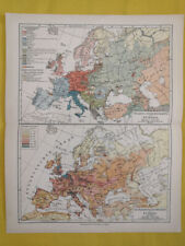 1905 EUROPE POPULATION DENSITY Map Vintage Eng ORIGINAL 11.5 x 9.5" C12-7
-
$4.73 CAD
 Taride's Motor Maps of France; Section No. 6 Nord; Carte Routière Pour Cyclistes
-
$30.02 CAD
 1907 - Metz, France - Original Vintage Geography Map - C10-3
-
$51.96 CAD
 1900 ALPS RANGE MAP Vintage Europe Italy Mountains ORIGINAL 16 x 9.5" - C12-8
-
$51.96 CAD
 1900 ALPS RANGE MAP Vintage Europe Italy Mountains ORIGINAL 16 x 9.5" - C12-8
-
$34.13 CAD
 1900s EUROPEAN COLONIES Vintage Atlas Map ORIGINAL 11.5 x 9.5" C12-9
-
$51.96 CAD
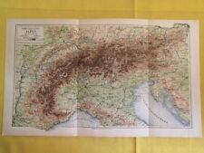 1900 ALPS RANGE MAP Vintage Europe Italy Mountains ORIGINAL 16 x 9.5" - C12-8
-
$47.98 CAD
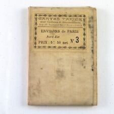 Cartes Taride Pour Cyclistes et Automobilistes No. 3 Environs de Paris Nord-Est
-
$51.96 CAD
 1900 ALPS RANGE MAP Vintage Europe Italy Mountains ORIGINAL 16 x 9.5" - C12-8
-
$15.08 CAD
 BREST France Original map city plan 1894 Brittany
-
$30.02 CAD
 1902 CENTRAL EUROPE Vintage Geography Map Mountains ORIGINAL 9.5 x 6.5"- C12-5
-
$40.99 CAD
 1887 EUROPE CONTINENT Vintage Geographical Map Color ORIGINAL C12-7
-
$34.13 CAD
 1902 CENTRAL EUROPE Vintage Geography Map Mountains ORIGINAL 11.5 x 9.5"- C12-3
-
$135.71 CAD
 W. and A.K. Johnston's Roller Map France 1429 and Scotland 1306 RARE!
-
$27.40 CAD
 Rand McNally Hallwag Map EUROPE With Distoguide 1992/93, ISBN 0528914731 Vintage
-
$43.87 CAD
 Cartes Taride Vintage Map on Linen Paris France no 3
-
$13.64 CAD
 Frankreich Reisekarte France travel map deutsch English français MAIRS 1:500000
-
$40.99 CAD
 1887 EUROPE CONTINENT Vintage Geographical Map Color ORIGINAL C12-7
-
$15.08 CAD
 Vtg 1954 Europe Resource Relief Economic Illustrated Map USSR Germany Sweden
-
$45.10 CAD
 1890 Mediterranean Countries Vintage Geographical Map ORIGINAL 19 x 9.5" C12-6
-
$30.02 CAD
 1897 ORIGINAL VINTAGE MAP Lyon, France Meyers Konversations-Lexikon C10-4
-
$40.99 CAD
 1902 EUROPE CONTINENT Vintage Geographical Map Color 11.5 x 9.5" ORIGINAL C12-7
-
$40.99 CAD
 1902 EUROPE CONTINENT Vintage Geographical Map Color 9.5 x 11.5 ORIGINAL C12-7
-
$30.02 CAD
 1897 ORIGINAL VINTAGE MAP Lyon, France Meyers Konversations-Lexikon C10-5
-
$21.60 CAD
 Paris France 1975 Vintage Michelin Road Map Plan De Paris IN FRENCH
-
$27.40 CAD
 Rand McNally Hallwag Map EUROPE With Distoguide 1994/95, ISBN 052895080
-
$45.10 CAD
 1898 Middle Europe Vintage Geographical Map ORIGINAL 19 x 9.5" Color C12-6
-
$17.12 CAD
 FRANCE 1937 Vintage COLOR Engraved MAP
-
$53.33 CAD
 1923 EUROPE 9th Century Vintage Large Geographical Map ORIG. 12.5 x 10.5" C13-1
-
$40.99 CAD
 1889 EUROPE CONTINENT Geographical Map Political View Color ORIGINAL C12-3
-
$34.13 CAD
 1896 CRIME STATISTICS France Italy German Vintage Map ORIGINAL 11.5 x 9.5" C11-3
-
$34.13 CAD
 1896 DISEASE MAP Distribution German Vintage Map ORIGINAL 11.5 x 9.5" C11-5
-
$34.13 CAD
 1902 CENTRAL EUROPE Vintage Geography Map Mountains ORIGINAL 11.5 x 9.5"- C11-3
-
$53.33 CAD
 1877 EUROPE Vintage Large Geographical Map ORIG. Double Sided 12.5 x 10.5" C13-1
-
$397.55 CAD
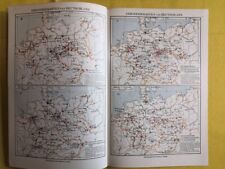
 1974 Vintage School Map-West Europe (Uk, Ireland, France, Belgium, Netherlands)


