 Antiques (CA)
-
$103.25 CAD

 Folding Pocket Map "ROUTE MAP OF MARYLAND" - State Roads Commission - 1920
-
$48.18 CAD
 1915 MAP of QUEEN ANNE'S COUNTY WM BULLOCK CLARK, STATE GEOlOGIST. Folded Ok Con
-
$17.21 CAD
 Washington D.C. & Suburban Maryland AAA Vintage 1983 1984 Street Travel Map
-
$34.42 CAD
 2 Antique maps 1907 Chesapeake Md shellfish coast survey Somerset Wicomico
-
$8.26 CAD
 Vintage Chesapeake Bay 1977 Cedar Point Cove Hydrographic Map 39” x 24” Folded
-
$30.37 CAD
 Rand-McNally regional state map: EASTERN UNITED STATES © 2004 - paper
-
$55.27 CAD
 VTG~c.1930~Topography Map~HARPERS FERRY VA-W.VA-MD~20 x 16~Jefferson/Berkeley/WA
-
$55.27 CAD
 VTG~c.1934~Topography Map~ PATAPSCO, MD~20 x 16~US Geological Survey
-
$30.30 CAD
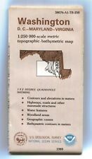
 USGS NOAA Topographic-Bathymetric Map WASHINGTON DC MD VA 1:250K -1989- 1x2° old
-
$25.62 CAD
 USGS NOAA Topographic-Bathymetric Map BALTIMORE MD PA VA WV 1:250K 1989 1x2°
-
$23.25 CAD
 Topographic Map of Charles County, Maryland
-
$25.62 CAD
 USGS NOAA Topographic-Bathymetric Map BALTIMORE MD PA VA WV 1:250K 1989 1x2° -Q-
-
$55.27 CAD
 VTG~c.1923~Topography Map~~20 x 16~MARYLAND-VIRGINIA NOMINI SHEET~Potomac River
-
$17.21 CAD
 AAA Delaware D.C. Maryland Virginia Vintage 1998 Driving Guide Travel Map
-
$43.36 CAD
 1891 MARYLAND DELAWARE MAP ANTIQUE FULL COLOR RAILROAD MOUNTAIN VICTORIAN ERA
-
$22.71 CAD
 1986 Trucker’s Wilmapco Region Original Vintage Map For DE, MD, NJ, PA
-
$13.75 CAD
 Original 1925 Map MARYLAND DELAWARE DISTRICT OF COLUMBIA Washington Baltimore
-
$67.46 CAD
 Large 1903 Railroad Map Baltimore Maryland Hollins Station Lake Roland Antg Vntg
-
$55.27 CAD
 VTG~c.1929~Topography Map~PAW PAW, MD-W. VA.-PA~20 x 16~Sidling Hill/Green Ridge
-
$25.15 CAD
 USGS Topographic Map CUMBERLAND - Maryland Pennsylvania West Virginia 1981 100K
-
$55.27 CAD
 VTG~c.1931~Topography Map~FREDERICK MD~Catoctin/Monocacy River~20 x 16~Quadrangl
-
$17.75 CAD
 USGS Geologic Map: Land-Use Planning, Prince Georges County, Maryland
-
$23.25 CAD
 Topographic Map of Anne Arundel County, Maryland
-
$55.00 CAD
 1855 MAP ~ COASTS OF DELAWARE, MARYLAND, VIRGINIA ~ From 1843 to 1855
-
$55.27 CAD
 VTG~c.1932~Topography Map~BRANDYWINE MD~20 x 16~Prince George/Charles Counties
-
$55.27 CAD
 VTG~c.1934~Topography Map~CHOPTANK, MD~20 x 16~Chesapeake Bay~Talbot/Tilghman Is
-
$96.09 CAD
 Antique 1901 Map Harford County Maryland Havre de Grace Aberdeen 30"X33" #21084
-
$82.32 CAD
 Antique 1901 Map Prince George County Maryland Laurel Bowie DC 24"X42" #21083
-
$34.91 CAD
 Map 1963 Vintage Folded Map Of Calhoun County, MI Issued By Road Commission
-
$27.95 CAD
 Rand-McNally regional state map: EASTERN UNITED STATES © 1993 -BAD-
-
$32.49 CAD
 Rand-McNally regional map: PHILADELPHIA & Vicinity Pennsylvania © 1997 -Index-
-
$31.58 CAD
 Rand-McNally state map: DELAWARE - MARYLAND - c.1995 - paper - highway
-
$67.46 CAD
 Large 48" Antique Map Baltimore Maryland Susquehanna Railroad Spring Hill 1853
-
$61.95 CAD
 Lg Rare 1914 Wall Map Montgomery County Maryland Bethesda Potomac Railroads
-
$34.42 CAD
 C&GS Coastal Map #557 Potomac River Chesapeake Bay To Piney Point 1973 18th Ed.
-
$61.95 CAD
 1851 US Coast Survey ,AD Bache Small Rare Map of Chesapeake Bay,United States
-
$23.35 CAD
 USGS Topographic Map KINGWOOD West Virginia Maryland 1981 1982 -100K-
-
$20.50 CAD
 Maryland Geologic Atlas: Mount Vernon and Piscataway Quadrangles
-
$30.41 CAD
 Rand-McNally regional state map: EASTERN UNITED STATES © 1993
-
$27.59 CAD
 USGS NOAA Topographic-Bathymetric Map TAPPAHANNOCK Virginia MD 1984 - 100K -
-
$52.31 CAD
 St Marys County Maryland Large Soil Map From 1901 Rolled Not Folded Leonardtown
-
$19.96 CAD
 1977 Amoco Gas Station Baltimore Vintage Map
-
$55.27 CAD
 VTG~c.1926~Topography Map~MARTINSBURG WV-VA-MD~20 x 16~Shepherdstown,Opequon,Ard
-
$61.95 CAD
 Folded Soil Survey Map Queen Annes County Maryland Centerville Grasonville 1931
-
$55.27 CAD
 VTG~c.1928~Topography Map~ HAGERSTOWN, MD-PA~20 x 16~South Mtn/Antietam Creek++
-
$24.45 CAD
 USGS NOAA Topographic-Bathymetric Map WASHINGTON DC MD VA 1:250K 1989 1x2° - BAD
-
$22.51 CAD
 USGS Topographic Map DC Maryland WASHINGTON EAST 1983 - 100K -
-
$27.52 CAD
 USGS NOAA Topographic-Bathymetric Map TAPPAHANNOCK Virginia MD 1984 - 100K - BAD
-
$55.27 CAD
 VTG~c.1917~Topography-War Dept~VIRGINIA-MARYLAND-HEATHSVILLE~20 x 16~US ARMY ENG
-
$25.10 CAD
 USGS Topographic Map LEONARDTOWN - Maryland Virginia - 1983 - 100K -
-
$55.27 CAD
 VTG~c.1934~Topography Map~TOLCHESTER MD~Havre de Grace~20 x 16~US Geological Svy
-
$55.27 CAD
 VTG~c.1921~Topography Map~OAKLAND MD-W.VA.-~20 x 16~Back Bone Mountain~Quadrangl
-
$17.75 CAD
 USGS Geologic Map: Construction Conditions, Prince Georges County, Maryland
-
$68.56 CAD
 Antique 1903 Map Worcester County Maryland Ocean City Snow Hill 34"X35" #21008
-
$25.44 CAD
 Alexis USA Universal GPS Grid Road Map: WEST VIRGINIA - DELAWARE - MARYLAND
-
$55.27 CAD
 VTG~Edition of 1913~Topography Map~NANJEMOY MD~20 x 16~Stafford Co/Potomac~Clark
-
$17.75 CAD
 USGS Geologic Map: Mineral Resources, Prince Georges County, Maryland
-
$17.75 CAD
 USGS Geologic Map: Southern Queen Annes County, Maryland - Aeromagnetic
-
$41.30 CAD
 1941-53 UNITED STATES COAST GUARD GEODETIC SURVEY CHESAPEAKE MARYLAND MAP 44X36
-
$55.27 CAD
 VTG~c.1933~Topography Map~ACCIDENT, MD-W. VA.-PA.~20 x 16~Western Allegheny Cnty
-
$55.27 CAD
 VTG~c.1930~Topography Map~ANTIETAM-MD-VA-W.VA.~20 x 16~Potomac/Elk Ridge/Catoct
-
$25.15 CAD
 USGS Topographic Map MORGANTOWN West Virginia Pennsylvania Maryland 1979 -BAD-
-
$20.64 CAD
 Vintage 1938 Map National Geographic Historic Reaches of the Nation's Capital
-
$55.27 CAD
 VTG~c.1924~Topography Map~Emmitsburg MD-PA~Catoctin MT~20 x 16~US Geological Svy
-
$55.27 CAD
 VTG~c.1921~Topography Map~DAVIS-W.VA.-MD~20 x 16~Monongohela National Forrest
-
$75.72 CAD
 1851 US Coast Survey ,AD Bache Small Rare Map of The Entrance To Chesapeake Bay,
-
$25.45 CAD
 USGS NOAA Topographic-Bathymetric Map - WASHINGTON D.C. MD VA - 1989 - 250K - F-
-
$17.75 CAD
 USGS Geologic Map: Water Resources of Southern Maryland
-
$68.83 CAD
 Original Antique 1868 RAILROAD Map Virgina WV Maryland Delaware NJ BATTLEFIELDS
-
$31.47 CAD
 USGS NOAA Topographic-Bathymetric Map WASHINGTON DC MD VA 1:250,000 -1989- 1x2°
-
$48.18 CAD
 1902 BALTIMORE BUSINESS ATLAS MAP ~ VEST POCKET MAP ~ 21 x 28 inches ~ Very Nice
-
$55.05 CAD
 Vintage Ephemera 1909 Karl Baedeker Traveling Folding Road Map DE,MD,Virginia,PA
-
$17.88 CAD
 USGS Index to Topographic Maps of Maryland April 1979 Geological Survey
-
$13.77 CAD
 Map of Maryland, Deleware and District of Columbia 1925
-
$55.05 CAD
 Vintage America 1909 Karl Baedeker Travel Folding Road Map Capital WashingtonDC
-
$55.05 CAD
 Vintage American 1909 Karl Baedeker Traveling Folding Road Map Baltimore, MD
-
$101.72 CAD
Folding Pocket MAP "ROUTE MAP OF MARYLAND" - State Roads Commission - 1920
-
$137.67 CAD
 Rare Antique Johnson’s Map Of PA, VA, DE, & MD circa 1862


