 Antiques (CA)
-
$563.08 CAD

 1907-10 George Philip Large Early London Underground Map
-
$124.99 CAD
 Bartholomew's Reduced Survey LOT 24 Cloth Maps Tourists & Cyclists, England & UK
-
$7.49 CAD
 Antique Ordnance Survey Folding Map Early 1900s - Sheffield, England Sheet 37
-
$7.49 CAD
 Antique Ordnance Survey Folding Map Early 1900s - England & Whales Sheet 53
-
$95.55 CAD
 Eighteenth Century Hand-Col. Map of London & Environs, 1787 - PRICE REDUCED
-
$50.00 CAD
 1930/40’s Royal Automobile Club Road Map Of England & Wales George Philip London
-
$34.13 CAD
 Bartholomews Historical Map Of London Cloth + Geographia LONDON Street Plan
-
$54.53 CAD
 WWI Allies' Map of Western Front George Philip & Son Ltd London Geo Inst
-
$27.29 CAD
 Bartholomew's Historical Map Of London Cloth - Vintage 1960's
-
$129.68 CAD
 Antique Map The Road from London to New Haven in Sussex England Hand Colored Map
-
$20.48 CAD
 Cook’s Handbook To London - 1926.
-
$68.18 CAD
 Bartholomew's Town Plan of London, Wartime Printing, Antique Fold-Out Map
-
$16.38 CAD
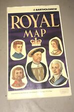 John Bartholomew Royal Map of England United Kingdom Scotland Kings and Queens
-
$156.98 CAD
 1920s England Motor Tour Map Wales Great Britain Driving Car Cars Auto Road Map
-
$7.49 CAD
 Antique Ordnance Survey Folding Map Early 1900s - England & Whales Sheet 27
-
$7.49 CAD
 Antique Ordnance Survey Folding Map Early 1900s - Warwick, England Sheet 184
-
$67.15 CAD
 The ES&A Bank: Chichester's Picture Map of London - 1955 - Vintage Map
-
$10.92 CAD
 1940’s MOTOR ROAD MAP of London & South-East England B.P. Anglo-Iranian Oil Co.
-
$784.90 CAD
 c. 1831, LARGE FOLDING MAP OF LONDON by G. CRUTCHLEY, with SLIPCASE
-
$604.31 CAD
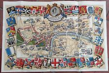 1953 Historic Queen Elizabeth II Royal Coronation Route Map London Pictorial
-
$28.00 CAD
 Vest Pocket Street Plan of Central London with Index to Streets (ca 1955)
-
$27.29 CAD
 1970's Johnston & Bacon Southern England & Wales No 1-Highway Road Map Fold-out
-
$34.11 CAD
 Vintage London Postal Districts Map Colored Edition
-
$34.13 CAD
 World War 1 MAP British Naval "OPERATIONS of BATTLE CRUISER FLEET" WW1 WWI
-
$611.02 CAD
 Rare Royal Wedding 1947 Daily Telegraph Picture Map of London, Pictorial Route
-
$409.51 CAD
 Cruchley's Environs of London 1823 Folding Map in Case British Politician
-
$136.49 CAD
 Antique 1923 Geographia Pictorial Plan of London Folding Street Map 20" x 30"
-
$16.37 CAD
 British Isles and Northern Ireland map National Geographic Vintage Pilgrim 1937
-
$7.49 CAD
 Antique Ordnance Survey Folding Map Early 1900s - England & Whales Sheet 20
-
$7.49 CAD
 Antique Ordnance Survey Folding Map Early 1900s - Bradford, England Sheet 69
-
$713.24 CAD
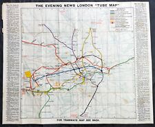
 1908 UERL Johnson & Riddle Antique London Underground Map Rare 2nd Map Published
-
$7.49 CAD
 Antique Ordnance Survey Folding Map Early 1900s - England & Whales Sheet 25
-
$32.23 CAD
 Vintage The Practical Motorist Road Map Of Great Britain 1964
-
$39.59 CAD
 Rare Antique Interwar Map "The Heart Of The Empire"
-
$819.03 CAD
 LONDON LARGE CRUCHLEY'S FOLDING MAP DATED 1850 19TH CENTURY
-
$17.73 CAD
 Vintage LONDON BIG BEN MAP 1985 Geographia Ltd. Import From London, England.
-
$122.84 CAD
 Visitor's Guide to London 1879 Foldout Map W. H. Smith & Son's
-
$20.48 CAD
 Antique Road Map Complete - 35 Miles Round To London - Geographers' Map Co. LTD
-
$7.49 CAD
 Antique Ordnance Survey Folding Map Early 1900s - Scarborough, England Sheet 23
-
$6.99 CAD
 Antique Ordnance Survey Folding Map Early 1900s - Andover, England Sheet 283
-
$313.89 CAD
 Antique 1932 Geographia Ltd The Pictorial Plan of London Folding Street Map
-
$170.62 CAD
 Original c 1870 WH Smith Linen Backed Hand Colored Environs of London Map
-
$1200.00 CAD
 Environs of London, 1841
-
$136.49 CAD
 Vtg Lot Bacon`s Philips Son's Hotel Large Print Map England RARE Antique
-
$7.49 CAD
 Antique Ordnance Survey Folding Map Early 1900s - England & Whales Sheet 45
-
$7.49 CAD
 Antique Ordnance Survey Folding Map Early 1900s - Winchester, England Sheet 124
-
$6.81 CAD
 South East England 1997 Ordnance Survey Map, Travelmaster 9
-
$7.49 CAD
 Antique Ordnance Survey Folding Map Early 1900s - England & Whales Sheet 33
-
$7.64 CAD
 Northern England 1993 Ordnance Survey Map, Travelmaster 5
-
$40.88 CAD
 Vintage LONDON BIG BEN MAP 1985 Geographia Ltd. Import From London, England
-
$23.19 CAD
 Vintage London Big Ben Map 1970s Geographia Ltd. Made In London, England
-
$6.81 CAD
 South East England 1997 Ordnance Survey Map, Travelmaster 9
-
$20.14 CAD
 Cintage Practical Mororist Holiday And Touring Map Of Great Britain 1964
-
$61.43 CAD
 PICTURE MAP OF LONDON. "Geographica" circa 1920. Linen backed.
-
$266.18 CAD
 Vintage c.1773 MAP OF SCOTLAND & HEBRIDES Old Antique Original PUBLISHED c.1830
-
$34.11 CAD
 A to Z Motorist's Map - Central London - Geographers' - One-Way Streets - Park
-
$12.29 CAD
 Vintage Britian British Airways Road Map, London, Orkney, Shetland Islands Maps
-
$546.02 CAD
 1906 London in the Beginning of the 20th Century / The Pictorial Plan of London
-
$54.60 CAD
 Vintage Bacon’s Large Scale Plan of Portsmouth - Cloth Cover Map Book
-
$10.22 CAD
 Map England 1611 May 1964 Vintage National Geographic 19x25 Great Britain
-
$204.76 CAD
 ORDNANCE MAP of the SW ENVIRONS of LONDON 1891 Linen Edward Stanford
-
$34.11 CAD
 30 Miles Round London "Geographia" District Road Map 3/6 Paper:6/6 Cloth


