 Antiques (CA)
-
$53.23 CAD

 1924 POLAND Vintage Large Geographical Map ORIG. Italian 12.5 x 10.5" C13-1
-
$53.23 CAD
 1905 WORLD MERCATOR Currents Vintage Large Map ORIG. Italian 12.5 x 10.5" C13-1
-
$116.32 CAD
 Vintage framed Map and illustrations of Derbyshire England colored
-
$197.01 CAD
 1829 J Cary / Cary's Six Sheet Map of England and Wales with Part of Scotland
-
$3.82 CAD
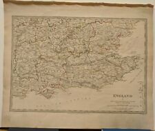
 1897 Southampton location map. England Original antique print
-
$88.95 CAD
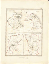
 LATE 18TH MAP OF ENGLAND'S NORTH RIDING & YORKSHIRE BY EMAN BOWEN
-
$34.08 CAD
 1902 INDUSTRIAL MAP GERMANY Vintage Economical ORIGINAL 11.5 x 9.5" C11-8
-
$34.08 CAD
 1897 DISTRIBUTION OF JEWS GERMANY Vintage Map ORIGINAL 11.5 x 9.5" C12-3
-
$95.73 CAD
 1746 Map of Hertfordshire England - Thomas Kitchin - Hartfordshire - Temperance
-
$15.38 CAD
![1950s Wonderful Britain map, Places to visit, Newcastle, 26x20cm [26722]](https://i.ebayimg.com/thumbs/images/g/hhgAAOSwSoFl4KTl/s-l225.jpg) 1950s Wonderful Britain map, Places to visit, Newcastle, 26x20cm [26722]
1950s Wonderful Britain map, Places to visit, Newcastle, 26x20cm [26722]
-
$40.92 CAD
 1902 EUROPE CONTINENT Vintage Geographical Map Color 9.5 x 11.5 ORIGINAL C12-7
-
$34.08 CAD
 1928 INDUSTRIAL MAP GERMANY Vintage Economical ORIGINAL 11.5 x 9.5" C12-6
-
$41.04 CAD
 Original 1841 FOX HUNTING Map "Meets of the Petchley Hounds" Northampton England
-
$65.00 CAD
 England & Wales London York Manchester Cardiff 1895 Bacon 3 sheet map
-
$67.06 CAD
 Liverpool Merseyside England 1881 Edward Weller detailed city plan 2 sheet map
-
$29.97 CAD
 1900 ENGLAND WALES Vintage Map York North Sea London German Original COLOR C10-9
-
$4.91 CAD
 A-Z Roadmap and Index of Northern England
-
$34.08 CAD
 1897 EUROPE ECONOMICAL Map Vintage Ethnographic ORIGINAL 11.5 x 9.5" C11-8
-
$20.51 CAD
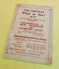 Vintage 1940's RIVER THAMES Westminster England FERRY SCHEDULE Map & Fares Slip
-
$34.08 CAD
 1909 BRITISH COLONIES MERCATOR Map Vintage Sea Travel ORIGINAL 11.5 x 9.5" C12-3
-
$34.08 CAD
 1905 EUROPE POPULATION DENSITY Map Vintage Eng ORIGINAL 11.5 x 9.5" C11-8
-
$34.08 CAD
 1905 EUROPE MERCATOR Map Vintage Sea Travel Climate ORIGINAL 11.5 x 9.5" C12-2
-
$37.98 CAD
 Vintage Color Map ~ BRITISH ISLES ~ ENGLAND IRELAND SCOTLAND WALES Printed 1883
-
$20.53 CAD
 1900'S CLEAR PRINT MAP LONDON BY GEO PHILIP & SON
-
$29.97 CAD
 1895 ENGLAND WALES Vintage Geological Map North Sea German Original COLOR C10-8
-
$61.58 CAD
 1943 US Navy Nautical Map England Southeast Coast Folkestone Harbour 4503 22x28"
-
$34.08 CAD
 1900 London England City Vintage Geography Map ORIGINAL 11.5 x 9.5" C12-9
-
$35.44 CAD
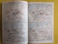
 1924 HISTORY OF EUROPE Vintage Geographical Map Color ORIGINAL C12-3
-
$51.87 CAD
 1896 London United Kingdom - Vintage Large City Map ORIGINAL 14.5 x 9.5" - C12-9
-
$51.87 CAD
 1896 London United Kingdom - Vintage Large City Map ORIGINAL 14.5 x 9.5" - C12-9
-
$34.08 CAD
1905 EUROPE MERCATOR Map Vintage Sea Travel Climate ORIGINAL 11.5 x 9.5" C11-8
-
$156.01 CAD
 Antique map, Vest Pocket Street Plan of Central London LONDON MAP CARTOGRAPHY
-
$26.00 CAD
 1859 Antique Color MITCHELL Map ~ EUROPE ~ Original ~ Extremely Rare
-
$29.08 CAD
 Ordinance Survey 1/4 Inch Map of Great Britain 1946 England South-West Sheet 10
-
$34.08 CAD
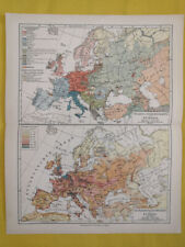 1905 EUROPE POPULATION DENSITY Map Vintage Eng ORIGINAL 11.5 x 9.5" C12-7
-
$40.92 CAD
 1887 EUROPE CONTINENT Vintage Geographical Map Color ORIGINAL C12-7
-
$29.97 CAD
 1910 ORIGINAL VINTAGE MAP - England, Wales - C10-3
-
$40.92 CAD
 1889 EUROPE CONTINENT Geographical Map Political View Color ORIGINAL C12-3
-
$67.06 CAD
 England & Wales London Cardiff York Manchester 1860 Blackie two sheet map
-
$45.02 CAD
 1890 Mediterranean Countries Vintage Geographical Map ORIGINAL 19 x 9.5" C12-6
-
$14.99 CAD
 Antique 1880 Ireland-England-Scotland book plate Map 9 x 12-suitable to frame
-
$42.14 CAD
 1835 Walker Antique Map Scarborough Whitby New Malton North Allerton, Yorkshire
-
$29.97 CAD
 1895 GREAT BRITAIN Vintage Map Isles North Sea London Original COLOR C12-3
-
$43.79 CAD
 1879 Map Europe Spain France Italy England Victorian Geography 1st Edition DWAA9
-
$40.92 CAD
 1887 EUROPE CONTINENT Vintage Geographical Map Color ORIGINAL C12-7
-
$40.92 CAD
 1902 EUROPE CONTINENT Vintage Geographical Map Color 9.5 x 11.5 ORIGINAL C12-7
-
$43.79 CAD
 1879 Map British Isles England Scotland Victorian Geography 1st Edition DWAA9
-
$45.02 CAD
 1898 Middle Europe Vintage Geographical Map ORIGINAL 19 x 9.5" Color C12-6
-
$40.92 CAD
 1902 EUROPE CONTINENT Vintage Geographical Map Color 11.5 x 9.5" ORIGINAL C12-7
-
$205.28 CAD
 Reprint Map of Kent Original by John Speed Theatre of the Empire Great Britaine
-
$49.66 CAD
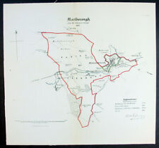 1832 Robert Kearsley Dawson Antique Map City of Marlborough Wiltshire, England
-
$45.02 CAD
 1898 Middle Europe Vintage Geographical Map ORIGINAL 19 x 9.5" Color C12-8
-
$45.02 CAD
 1898 Middle Europe Central Vintage Geographical Map ORIGINAL 19 x 9.5" C12-6
-
$376.34 CAD
 ORIG. NAUTICAL CHART - COASTS OF ENGLAND, FLANDERS & HOLLAND -MOUNT & PAGE -1750
-
$45.02 CAD
 1898 Middle Europe Vintage Geographical Map ORIGINAL 19 x 9.5" Color C12-8
-
$53.23 CAD
 1877 EUROPE Vintage Large Geographical Map ORIG. Double Sided 12.5 x 10.5" C13-1
-
$27.37 CAD
 England Wales United Kingdom 1935 Map Scotland London Europe 14 x 11" LGAD99
-
$26.00 CAD
 1889 Antique Great Britain 9 Maps Plates Encyclopedia York Saxony Kent Wilshire
-
$43.79 CAD
 1879 Political Map Europe And Western Asia Victorian Geography 1st Edition DWAA9
-
$444.76 CAD
 Antique c1619 WEST Coast of ENGLAND Framed Hand Colored Copper Engraving MAP
-
$40.90 CAD
 1897 MAP Baedeker - London & Environs England 10.5 x 15" (26.5 x 38 cm)
-
$57.48 CAD
 Repro Map of Warwickshire by Johannes Janssonius (c.1614) Reprint Used VG
-
$13.69 CAD
 ELGAR'S BELOVED COUNTRY Booklet - By Michael Grundy - Elgar Route122523
-
$19.16 CAD
 Map England And Wales Europe 1938 Atlas Print English Channel Irish Sea DWU7
-
$30.41 CAD
 Vintage Color Map ~ EUROPE ~ Printed 1883
-
$43.63 CAD
 1897 MAP Baedeker - England & Wales Railways 15 x 16" (38 x 41 cm)
-
$65.00 CAD
 United Kingdom England Scotland Wales 1862 Peterman detailed two sheet map
-
$97.75 CAD
 1912 LARGE ANTIQUE MAP ~ ENGLAND & WALES NORTHERN ~ LIVERPOOL LEEDS MANCHESTER
-
$41.06 CAD
 1810 Map England Wales Painted Engraver J. Wallis Antique Rare RB60
-
$24.63 CAD
 Ordnance Survey Aberystwyth 1966 Map
-
$24.63 CAD
 Ordnance Survey Merionethshire 1953 Map
-
$65.00 CAD
 United Kingdome England Scotland Wales London 1879 Petermann 2 sheet map
-
$21.90 CAD
 THAMES VALLEY Book - Colourmaster
-
$53.37 CAD
 vintage Geographia Road Map of Cheshire - published in London
-
$13.67 CAD
 EAST ANGLIA ENGLAND GREAT BRITAIN ORDNANCE SURVEY SHEET MAP 1962 VINTAGE
-
$376.34 CAD
 Antique 18th c Map of CHESHIRE England 1rst Published in 1607 Camden's Britannia
-
$821.10 CAD
 Antique Etching Scenery. Artist Unknown.
-
$42.14 CAD
 1835 Walker Antique Map Carlisle, Whitehaven, Cockermouth in Cumberland England
-
$20.53 CAD
 Vintage English Map of Motoring and Hiking Routes-1940's
-
$65.00 CAD
 British Isles Ireland United Kingdom England Scotland 1824 Vivien two sheet map
-
$20.53 CAD
 1838 SDUK: Map of England V - Southeast England
-
$82.11 CAD
 Antique Map of Nomandie France, Southern England, English Channel 1797 Italian
-
$1094.80 CAD
 Vintage Map Of Surrey Described And Decided Into Hundreds by Speed c1614
-
$20.53 CAD
 1830 SDUK: Map of England V - Southeast England
-
$27.36 CAD
 Map of England - Reproduction 20" x 15"
-
$20.53 CAD
 1830 SDUK: Map of England V - Southeast England
-
$151.70 CAD
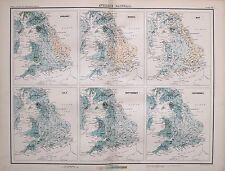
 1897 ANTIQUE MAP ENGLAND & WALES LAND SURFACE FEATURES WOODLAND CULTIVATED LAND
-
$151.70 CAD
 1897 ANTIQUE VICTORIAN MAP ECCLESIASTICAL DIVISIONS ENGLAND & WALES OXFORD RIPON
-
$150.66 CAD
 1897 ANTIQUE MAP ENGLAND & WALES SOUTH LONDON BIRMINGHAM READING CARMARTHEN
-
$444.76 CAD
 Antique c1648 Northwestern ENGLAND Framed Hand Colored Copper Engraving MAP
-
$151.70 CAD
 1897 ANTIQUE MAP ENGLAND & WALES PARLIAMENTARY REPRESENTATION YORK BOROUGHS
-
$150.66 CAD
 1897 ANTIQUE MAP ENGLAND & WALES NORTHERN RAILWAYS LIVERPOOL MANCHESTER CARLISLE
-
$150.66 CAD
 1897 ANTIQUE MAP ENGLAND & WALES AVERAGE TEMPERATURE CENTRAL PLAIN JULY NOVEMBER
-
$150.66 CAD
 1897 VICTORIAN ANTIQUE MAP ENGLAND & WALES AVERAGE RAINFALL JANUARY SALISBURY
-
$40.99 CAD
 1835 Hand Colored Map of Westminster, London Showing the Extent of 1222 In Blue
-
$80.91 CAD
 1901 LARGE VICTORIAN COUNTES MAP OF ENGLAND & WALES & SOUTHERN SCOTLAND
-
$4.93 CAD
 Great Britain Leisure Maps:Herts & Bucks Bartholomew Sheet map
-
$150.66 CAD
 1897 ANTIQUE VICTORIAN MAP ENGLAND & WALES DENSITY OF POPULATION LONDON GLASGOW
-
$29.97 CAD
1903 ENGLAND WALES Vintage Map York North Sea London German Original COLOR C10-8
-
$40.92 CAD
1907 GOVERNMENT TYPES Europe Map Ethnographic ORIGINAL C11-6


