 Antiques (CA)
-
$67.04 CAD

 1889 Switzerland Map ORIGINAL Zurich Geneva Bern Cantons Townships Railroads
-
$86.40 CAD
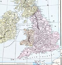 1898 British Isles Historical Map England Ireland Scotland Wales London
-
$65.83 CAD
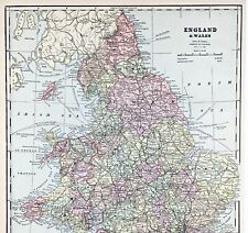 ENGLAND WALES Map 1889 ORIGINAL London Dover Railways Counties Townships G. CRAM
-
$91.35 CAD
 Milton Abbey Abbas Dorset England Great Britain Copperplate 1770
-
$54.79 CAD
 Vintage framed Hand Stitched Map Of England And Wales 20.5" x 16.5"
-
$30.17 CAD
 Sidmouth to Portsmouth Region, England - Original 1922 Ordnance Survey Map.
-
$50.00 CAD
 Vintage Map of Portland England by Prudence Turner in Wooden Frame
-
$37.14 CAD
 Bryanston Dorset Manor Castle England Engraving Copperplate Van Der Aa 1707
-
$71.99 CAD
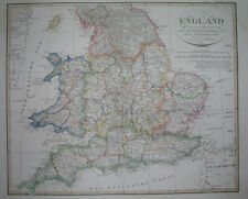 1823 ORIGINAL MAP UNITED KINGDOM ENGLAND WALES LONDON CAMBRIDGE LANCASTER YORK
-
$52.79 CAD
 1838 nice ORIGINAL MAP UNITED KINGDOM ENGLAND WALES LONDON CARDIFF MANCHESTER
-
$47.30 CAD
 1848 nice ORIGINAL MAP UNITED KINGDOM ENGLAND WALES LONDON LIVERPOOL CARDIFF
-
$12.34 CAD
 Dorset pictorial guide of places to visit in tourist map
-
$91.35 CAD
 Ranston House Iwerne Courtney Dorset England Great Britain Copperplate 1770
-
$139.11 CAD
 Bryanston House Dorset Dorsetshire England Garden Kip Map Engraving
-
$137.13 CAD
 1882 Needles Christchurch Antique Sea Chart Coastal Map South England UK (1891)
-
$21.93 CAD
 ANTIQUE 1842 DORSETSHIRE COUNTY DORSET ENGLAND HANDCOLORED MAP RARE FINE NR
-
$78.84 CAD
 1823 ORIGINAL MAP IRELAND UNITED KINGDOM ENGLAND WALES SCOTLAND DUBLIN LONDON
-
$68.57 CAD
 1736 Ogilby /Bowen The Road from London to Weymouth come Dorset
-
$137.13 CAD
 1872 Portland Harbour Antique Sea Chart Coastal Map South England UK (1895)
-
$9.59 CAD
 Vale of Severn Bartholomew Great Britain Contoured Paper Fold-Up Map 1961
-
$9.59 CAD
 Dorset Bartholomew Great Britain Contoured Paper Fold-Up Map 1962
-
$15.07 CAD
 County of Dorset in England - Map Print -- 1907
-
$17.81 CAD
 Print of William Heather map of Dorset Coast 1900's. 47cm x 40cm Exc. Cond.
-
$171.43 CAD
 1835; Dorsetshire map; England; Coloured Hundred Boundaries; Dugdale/Tallis


