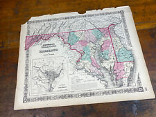
 Antiques (CA)
-
$177.59 CAD

 Vintage 1948 (36" x 23") MARYLAND MAP - HARFORD COUNTY Topo & Election Districts
-
$199.61 CAD
 Richard Yardley 1968 historical cartoon map of Baltimore County Maryland 16x20
-
$177.59 CAD
 Vintage 1949 LARGE MARYLAND MAP - HOWARD COUNTY Topography & Election Districts
-
$172.08 CAD
 1948 - Map of the ZONING PLAN For VIERS MILL ROAD - Montgomery County, Maryland
-
$28.47 CAD
 Old Vintage 1925 State & County Map ~ MARYLAND - DELAWARE ~ Free S&H
-
$48.17 CAD
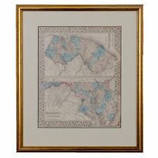
 Rare 1855 MARYLAND & DELAWARE Map w/ Colored Counties ~ 18" X 14", Johnson Map
-
$27.46 CAD
 Chesapeake Bay Country Map Antique 1923 Compiled by Swepson Earle 14" x 10"
-
$63.26 CAD
 Antique 1875 Railroad & County Map ~ MID-ATLANTIC STATES ~ NY - PA - NJ - VA
-
$28.47 CAD
 Old Antique 1901 Atlas Map ~ MARYLAND - DELAWARE - BALTIMORE COUNTY ~ Free S&H
-
$275.33 CAD
 Richard Yardley 1960s Baltimore Sun Map Historical Baltimore County Maryland
-
$123.90 CAD
 MID-ATLANTIC -- Map / County Map of Pennsylvania New Jersey Maryland 1860
-
$55.05 CAD
 2 - 1877 Maps of Manchester in Carroll County, MD by Lake Griffing & Stevenson
-
$757.16 CAD
 1877 Hand-Colored Street Map of Cambridge Maryland Dorchester County
-
$172.08 CAD
 1948 - Map of the HIGHWAY PLAN For VIERS MILL ROAD - Montgomery County, Maryland
-
$185.85 CAD
 1947 - Map of the ZONING PLAN For ROCKVILLE PIKE - Montgomery County, Maryland
-
$87.76 CAD
 Washington County Maryland Antietam South Mountain Civil War Battles 1862 map
-
$13.75 CAD
 1877 Scenes - Westminster Court House Carroll County, MD Lake Griffing Stevenson
-
$1317.00 CAD
 RARE 1791 Map UNITED STATES FRENCH POSSESSION ORIGINAL 18th century map
-
$19.08 CAD
 1892 Color Single Page County Maps Maryland & Delaware Virginia & West Virginia
-
$14.95 CAD
 1911 Color County Map of Maryland and Delaware States
-
$41.02 CAD
 1903 Antique Map Virginia WV MD Leesburg Purcellville Harpers Ferry 22X26 #4248
-
$39.76 CAD
 VINTAGE MARYLAND Map 1912 ORIGINAL Counties Population Annapolis Baltimore
-
$96.35 CAD
 2 - 1877 Maps - Westminster in Carroll County, MD by Lake Griffing & Stevenson
-
$96.09 CAD
 Antique 1901 Map Harford County Maryland Havre de Grace Aberdeen 30"X33" #21084
-
$82.32 CAD
 Antique 1901 Map Prince George County Maryland Laurel Bowie DC 24"X42" #21083
-
$68.82 CAD
 1867 County Map of New Jersey & County Map of Maryland and Delaware hand-colored
-
$61.95 CAD
 Lg Rare 1914 Wall Map Montgomery County Maryland Bethesda Potomac Railroads
-
$52.31 CAD
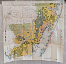
 St Marys County Maryland Large Soil Map From 1901 Rolled Not Folded Leonardtown
-
$227.15 CAD
 NEWFOUNDLAND NOVA SCOTIA GREAT LAKES REGION CANADA 14x18 Print MAP Labrador
-
$48.18 CAD
 1915 MAP of QUEEN ANNE'S COUNTY WM BULLOCK CLARK, STATE GEOlOGIST. Folded Ok Con
-
$68.82 CAD
 Thomas Bros Guide Metropolitan Washington Dc  1998 atlas- Washington DC Area
-
$134.57 CAD
 Thomas Bros Guide MONTGOMERY COUNTY & THE BELTWAY 1998 atlas- Washington DC Area
-
$68.76 CAD
 1915 SPARROWS POINT, BALTIMORE COUNTY, MARYLAND, PENNWOOD PARK, ATLAS MAP
-
$27.52 CAD
 1877 Hampstead Snydersburg Carroll County, MD Map by Lake Griffing & Stevenson
-
$27.52 CAD
 1877 Map - New Windsor in Carroll County, MD by Lake Griffing & Stevenson
-
$59.18 CAD
 1865 MARYLAND & DELAWARE Map, Colored Counties Historical Civil War Era, 18"x14"
-
$34.40 CAD
 1877 Map - Freedom Finksburg in Carroll County, MD by Lake Griffing & Stevenson
-
$68.76 CAD
 1915 CATONSVILLE, BALTIMORE COUNTY, MARYLAND, MT. DE SALES ACADEMY, ATLAS MAP
-
$35.79 CAD
 Talbot County Realtors map 1875 printed as 17" X 22"
-
$34.91 CAD
 Map 1963 Vintage Folded Map Of Calhoun County, MI Issued By Road Commission
-
$61.95 CAD
 Folded Soil Survey Map Queen Annes County Maryland Centerville Grasonville 1931
-
$103.25 CAD
 1877 hand colored Lithograph Map Baltimore County: Pikesville Station
-
$27.52 CAD
 1877 Middleburg in Carroll County, MD Map by Lake Griffing & Stevenson
-
$20.65 CAD
 VINTAGE MAP OF MARYLAND AND DELAWARE IN COLOR COUNTIES CITIES AND TOWNS MS1220
-
$34.40 CAD
 1877 Union Bridge Carroll County, MD Map by Lake Griffing & Stevenson
-
$68.56 CAD
 Antique 1903 Map Worcester County Maryland Ocean City Snow Hill 34"X35" #21008
-
$28.90 CAD
 1900 Antique COLOR Map///MARYLAND & DELAWARE, WITH INSET MAP OF BALTIMORE COUNTY
-
$275.33 CAD
 Richard Yardley 1960s Baltimore Sun Map Historical Anne Arundel County Maryland
-
$26.84 CAD
 MARYLAND & DELAWARE Map: Authentic 1907 (dated) County Town Topography Railroads
-
$34.40 CAD
 c 1890 Cram Map Maryland Delaware Washington DC Baltimore Alexandria Annapolis
-
$68.76 CAD
 1915 G.W. BROMLEY BALTIMORE COUNTY, MARYLAND, MCDONOGH INSTITUTE ATLAS MAP
-
$68.76 CAD
 1915 HALETHORPE BALTIMORE, COUNTY MARYLAND, LOUDON PARK CEMETERY ATLAS MAP
-
$54.93 CAD
 1900 Soil Map Cecil County Maryland Elkton Conowingo North East 27 X 29 #9250
-
$17.88 CAD
 1908 Colored Map MARYLAND & DELAWARE 13" X 10" ~ Counties, Cities, Historic Pts
-
$68.76 CAD
 1915 G.W. BROMLEY BALTIMORE COUNTY, MARYLAND, GILMAN COUNTRY SCHOOL ATLAS MAP
-
$41.29 CAD
 1877 Map - Franklin Union Bridge Carroll County, MD by Lake Griffing & Stevenson
-
$63.26 CAD
 1889 Map MARYLAND - DELAWARE (XL17x23) Colored - Good Condition - Free S&H#006
-
$103.25 CAD
 1877 hand colored Lithograph Map Baltimore County: Pikesville Green Spring
-
$34.42 CAD
 1965 TOPOGRAPHICAL Street Map of HOWARD COUNTY MARYLAND Ellicott City COLUMBIA
-
$68.76 CAD
 1915 BALTIMORE COUNTY MARYLAND ELKRIDGE FOX HUNTING CLUB G.W. BROMLEY LATLAS MAP
-
$41.30 CAD
 1964 LARGE COLOR WALL MAP of WORCESTER COUNTY MARYLAND Eastern Shore OCEAN CITY
-
$39.92 CAD
 1895 Antique MITCHELL Color Map of MARYLAND VIRGINIA NORTH & SOUTH CAROLINA
-
$61.95 CAD
 Color Soil Survey Map Cecil County Maryland Cecilton Charlestown Elkton MD 1900
-
$63.26 CAD
 Vintage Antique 1863 Railroad & County Map MARYLAND - DELAWARE Old & Authentic
-
$34.40 CAD
 1893 VIRGINIA Map w/ Colored Counties, Reverse MARYLAND & DELAWARE 14" x 10.5"
-
$26.14 CAD
 Cram's 1890 Colored Map MARYLAND & DE 22 1/4" x 16 1/4" Railroad & County Map
-
$68.76 CAD
 1898 BALTIMORE COUNTY MARYLAND SHEPPARD ASYLUM SORRENTO RUXTON HEIGHTS ATLAS MAP
-
$68.76 CAD
 1898 BALTIMORE COUNTY MARYLAND G.W. BROMLEY TITLE PAGE ATLAS MAP
-
$68.76 CAD
 1898 BALTIMORE COUNTY MARYLAND G.W. BROMLEY INDEX PAGE ATLAS MAP
-
$68.76 CAD
 1915 TOWSON BALTIMORE COUNTY MARYLAND ENDOWOOD STATION MONTE MARIA CEM ATLAS MAP
-
$530.01 CAD
 Original 1877 Hand-Colored Street Map of Salisbury Maryland Wicomico County
-
$68.76 CAD
 1915 LAURAVILLE, RASPEBURG, PARKVILLE, BALTIMORE COUNTY, MARYLAND ATLAS MAP
-
$34.42 CAD
 1983 LARGE COLOR WALL MAP of WICOMICO COUNTY MARYLAND Eastern Shore NANTICOKE
-
$68.76 CAD
 1915 BALTIMORE COUNTY MARYLAND NOTRE DAME ACADEMY GOVANSVILLE BROMLEY ATLAS MAP
-
$68.76 CAD
 1915 REISTERSTOWN, BALTIMORE COUNTY MARYLAND, GLYNDON BASEBALL GROUNDS ATLAS MAP
-
$169.53 CAD
1948 - Map of the ZONING PLAN For VIERS MILL ROAD - Montgomery County, Maryland
-
$68.76 CAD
 1915 BALTIMORE COUNTY MARYLAND HOSPITAL CANTONSVILLE LANSDOWNE STATION ATLAS MAP
-
$309.75 CAD
 1877 EASTERN SHORE Kent County MARYLAND MAP Hanesville WORTON STATION Smithville
-
$68.76 CAD
 1915 BALTIMORE COUNTY MARYLAND NEW MARYLAND & SUBURBAN COUNTRY CLUBS ATLAS MAP
-
$68.76 CAD
 1915 BALTIMORE COUNTY MARYLAND ST CHARLES COLLEGE LOUDON PARK CEMETERY ATLAS MAP
-
$68.76 CAD
 1915 BALTIMORE COUNTY MARYLAND JAMES LAWRENCE KERNAN HOSPITAL & SCHOOL ATLAS MAP
-
$75.70 CAD
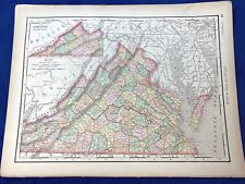
 Antique Map Middle States Pennsylvania, NY, NJ, Delaware, Maryland c1853
-
$169.53 CAD
1948 - Map of the HIGHWAY PLAN For VIERS MILL ROAD - Montgomery County, Maryland
-
$210.63 CAD
 County Map of Maryland, Delaware New Jersey by S. Augustus Mitchell, c. 1874
-
$68.76 CAD
 1915 G.W. BROMLEY BALTIMORE COUNTY, MARYLAND CONFEDERATE SOLDIERS HOME ATLAS MAP
-
$68.76 CAD
 1898 BALTIMORE COUNTY MARYLAND REISTERSTOWN HANNA MOORE ACADEMY ATLAS MAP
-
$68.76 CAD
 1915 BALTIMORE COUNTY MARYLAND HOLLOFIELD STATION, OELLA POST OFFICE, ATLAS MAP
-
$68.76 CAD
 1877 G.M. HOPKINS, BALTIMORE COUNTY, MARYLAND, INDEX PAGE, COPY PLAT ATLAS MAP
-
$217.51 CAD
 1877 Hand-Colored Street Map of Princess Anne Somerset County Maryland / 1st ed
-
$183.09 CAD
1947 - Map of the ZONING PLAN For ROCKVILLE PIKE - Montgomery County, Maryland
-
$34.42 CAD
 1961 TOPOGRAPHICAL Street Map of CAROLINE COUNTY MARYLAND Eastern Shore DENTON
-
$68.76 CAD
 1898 BALTIMORE COUNTY MARYLAND POWHATAN GWYNN OAK MONUMENTAL HEIGHTS ATLAS MAP
-
$68.76 CAD
 1915 G.W. BROMLEY BALTIMORE COUNTY, MARYLAND JOCKEY CLUB RACE TRACK ATLAS MAP
-
$68.76 CAD
 1915 G.W. BROMLEY, BALTIMORE COUNTY, MARYLAND, TITLE PAGE COPY PLAT ATLAS MAP
-
$103.25 CAD
1898 BALTIMORE COUNTY MARYLAND G.W. BROMLEY TITLE PAGE ATLAS MAP
-
$68.76 CAD
 1898 CANTON BALTIMORE COUNTY MARYLAND JOHNS HOPKINS BAYVIEW ASYLUM ATLAS MAP
-
$68.76 CAD
 1915 CANTON, BALTIMORE COUNTY, MARYLAND, LAZARETTO LIGHT HOUSE, PLAT ATLAS MAP
-
$68.76 CAD
 1915 LEEDS, MORRELL PARK, SHERWOOD PARK BALTIMORE COUNTY, MARYLAND, ATLAS MAP
-
$68.76 CAD
 1898 BALTIMORE COUNTY MARYLAND TRENTON BLACKROCK MT CARMEL RAYVILLE ATLAS MAP
-
$68.76 CAD
 1915 NORTH BEND BALTIMORE COUNTY MARYLAND WOODLAWN & LORRAINE CEMETERY ATLAS MAP


