 Antiques (CA)
-
$54.00 CAD

 Vintage 1904 LONDON ENGLAND Map 11"x14" ~ Old Antique Original BATTERSEA CHELSEA
-
$32.73 CAD
 Vintage 1920 Ireland Map Connaught Galway London Edinburgh Dublin City Insets
-
$68.74 CAD
 Vintage 1887 LONDON ENGLAND Map 21"x13" ~ Old Antique Original KENSINGTON PARK
-
$225.23 CAD
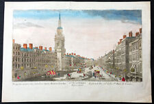 1760 Vue D Optic Large Antique Print View of Cheapside, London St Mary le Bow
-
$94.19 CAD
 Original antique J.H. Colton map of the Environs of London, 1855, 18.5"x16"
-
$63.83 CAD
 Vintage 1892 LONDON ENGLAND Map 22"x14" Old Antique Original HYDE PARK
-
$68.24 CAD
 5 Antique 1920’s/1940's LONDON ENGLAND MAPS/GUIDE BOOKS/ATLAS Paper/Cloth Travel
-
$34.11 CAD
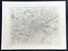
 Original 1882 Bartholomew Map CENTRAL LONDON Tower Subway England Westminster
-
$56.95 CAD
 Vintage 1901 LONDON ENGLAND UK Map 11"x14" ~ Old Antique Original REGENTS PARK
-
$34.13 CAD
 Bartholomews Historical Map Of London Cloth + Geographia LONDON Street Plan
-
$34.11 CAD
 1882 Antique COLOR Map / CITY OF LONDON, ENGLAND
-
$37.54 CAD
 1919 Antique London England City Map Street Map of London Wall Art 1234
-
$27.29 CAD
 Bartholomew's Historical Map Of London Cloth - Vintage 1960's
-
$563.08 CAD
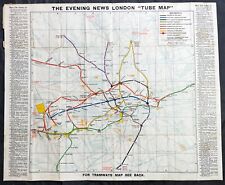 1907-10 George Philip Large Early London Underground Map
-
$32.62 CAD
 1877 London United Kingdom - Vintage City Map ORIGINAL 11.5 x 9.5" - C12-9
-
$57.05 CAD
 1836 Thomas Moule Antique Map of London & Environs, Barclays Dictionary
-
$30.03 CAD
 London England & Vicinity - Original 1908 Map by Meyers. Antique
-
$17.73 CAD
 Original 1882 Map LONDON England Marylebone Greenwich Hackney Southwark Finsbury
-
$25.85 CAD
 1908 ANTIQUE MAP CITY MAP OF LONDON ENGLAND / EDINBURGH SCOTLAND DUBLIN IRELAND
-
$20.48 CAD
 Cook’s Handbook To London - 1926.
-
$20.46 CAD
 Original 1902 Map VICINITY OF LONDON England Oxford Cambridge Suffolk Railroads
-
$32.76 CAD
 1927 STANFORD'S WALL MAP CENTRAL LONDON ENGLAND W/ Subways & Rails - Repro
-
$68.18 CAD
 Bartholomew's Town Plan of London, Wartime Printing, Antique Fold-Out Map
-
$57.33 CAD
 Antique Map - South London in 1813
-
$64.85 CAD
 1955 ORIGINAL VINTAGE MAP OF CITY OF LONDON AND VICINITY / ENGLAND
-
$8.18 CAD
 Vintage 1940 World Atlas City Map of Central London, England World War WWII OLD
-
$604.31 CAD
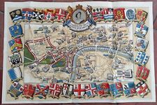 1953 Historic Queen Elizabeth II Royal Coronation Route Map London Pictorial
-
$54.59 CAD
 Original 1835 LONDON Borough Maps ST. MARYLEBONE & FINSBURY England Paddington
-
$33.99 CAD
 1900 London England City Vintage Geography Map ORIGINAL 11.5 x 9.5" C12-9
-
$51.74 CAD
 1896 London United Kingdom - Vintage Large City Map ORIGINAL 14.5 x 9.5" - C12-9
-
$33.99 CAD
 1934 London United Kingdom - Vintage Geography Map ORIGINAL 11.5 x 9.5" - C11-9
-
$51.74 CAD
 1896 London United Kingdom - Vintage Large City Map ORIGINAL 14.5 x 9.5" - C12-9
-
$38.63 CAD
 1889 ANTIQUE MAP OF LONDON THE CITY FROM ST. PAUL'S TO THE TOWER / ENGLAND
-
$8.18 CAD
 Vintage 2 Pg 1924 Post WWI B&W City Map London England & Liverpool England L@@K!
-
$16.37 CAD
 1937 Map London England Thames Westminister Parliament Picadilly Circus Strand
-
$40.95 CAD
 Antique London National Gallery Plan 1903
-
$88.73 CAD
 Vintage Lot of British Decor London Map, England/Scotland Road Atlas, Art Prints
-
$28.00 CAD
 Vest Pocket Street Plan of Central London with Index to Streets (ca 1955)
-
$713.24 CAD
 1720 Herman Moll Large Antique Map of France in Provinces - Pre Revolution
-
$32.62 CAD
 1899 London United Kingdom - Vintage City Map ORIGINAL 11.5 x 9.5" - C11-9
-
$34.11 CAD
 1882 Antique COLOR Map / CENTRAL LONDON, ENGLAND
-
$47.78 CAD
 MAP OF LONDON, ca. 1920, plate 25 from "The Times Survey Atlas of the World."
-
$109.19 CAD
 1755 CITY OF LONDON MAP BY BENJAMIN COLE- CORDWAINER & BREAD STREET WARDS
-
$40.95 CAD
 1911 Plan of Natural History Museum London British Map
-
$13.64 CAD
 1938 Collier Atlas Map London City Plan Westminister Museum Parks Railroads
-
$611.02 CAD
 Rare Royal Wedding 1947 Daily Telegraph Picture Map of London, Pictorial Route
-
$341.26 CAD
 BACON'S LARGE ANTIQUE MAP OF LONDON & SUBURBS c. 1900-1910
-
$16.64 CAD
 1935 CITY OF LONDON ENGLAND - City Map 11" X 14"
-
$409.51 CAD
 Cruchley's Environs of London 1823 Folding Map in Case British Politician
-
$32.75 CAD
 1886 London Bird's Eye View Map - Piccadilly - Regent Circle to Hyde Park Corner
-
$32.75 CAD
 1886 Victoria London Bird's Eye View Map Regent Street Waterloo Place Oxford Cir
-
$136.49 CAD
 Antique 1923 Geographia Pictorial Plan of London Folding Street Map 20" x 30"
-
$25.94 CAD
 LONDON Vicinity Map 1897 England Original
-
$313.89 CAD
 Antique 1932 Geographia Ltd The Pictorial Plan of London Folding Street Map
-
$38.21 CAD
 1886 Victoria London Bird's Eye View Map Cannon Street - The Tower Mansion House
-
$31.26 CAD
 VINTAGE BACON'S ATLAS OF LONDON FIRST PRINT 1959 ENLARGED EDITION RARE
-
$853.16 CAD
 Plan of London in the reign of Queen Elisabeth.
-
$1200.00 CAD
 Environs of London, 1841
-
$24.57 CAD
 c. 1890 UK ENGLAND LONDON DOWN TOWN CITY PLAN Antique Map
-
$122.85 CAD
 Richmond Park, London, steelengraving, anno 1860, Bibliographisches Institut
-
$750.78 CAD
 LONDON ENGLAND 1700 NICOLAS DE FER NICE ANTIQUE ENGRAVED CITY MAP 17TH CENTURY
-
$120.11 CAD
 1773 Francis Grose Large Antique Print of The London Charterhouse, Farringdon
-
$61.43 CAD
 PICTURE MAP OF LONDON. "Geographica" circa 1920. Linen backed.
-
$54.60 CAD
 Vintage Bacon’s Large Scale Plan of Portsmouth - Cloth Cover Map Book
-
$40.88 CAD
 1835 Hand Colored Map of Westminster, London Showing the Extent of 1222 In Blue
-
$204.76 CAD
 ORDNANCE MAP of the SW ENVIRONS of LONDON 1891 Linen Edward Stanford
-
$27.29 CAD
 1707 Pieter Van Der Aa Limited Edition Map England River Thames London 292/400
-
$187.69 CAD
 1947 Bartholomew Antique London Pocket Atlas 12mo, Beck Underground & 27 Maps
-
$99.77 CAD
 1891 VICTORIAN MAP STREET PLAN LONDON GREAT ILFORD CITY CEMETERY CLEMENTS
-
$147.94 CAD
 1883 LARGE MAP BRITISH ISLES SUSSEX KENT LONDON ESSEX HARWICH BRIGHTON LEWES
-
$136.49 CAD
 Vtg Lot Bacon`s Philips Son's Hotel Large Print Map England RARE Antique


