 Antiques (CA)
-
$130.78 CAD

 Chicago Antique 1895 Original Edgebrook SUB Map In Chicago TOTALLY AMAZING REPRO
-
$137.67 CAD
 Antique 1902 Booklet Railroad Map Of INDIANA - Shows ALL Railroads in 1902 REPRO
-
$48.18 CAD
 Vintage 1970 Geologic Map of the Chicago Quadrangle, IN, IL, MI Folding Paper
-
$20.64 CAD
 Vintage 1964? Illinois Tollway Map Chicago 20.5”x18”
-
$158.31 CAD
![[Colorado] 1927 Automobile Road Map Chicago Tribune/Rand McNally 1927](https://i.ebayimg.com/thumbs/images/g/4kwAAOSwD1NhdvQO/s-l225.jpg) [Colorado] 1927 Automobile Road Map Chicago Tribune/Rand McNally 1927
[Colorado] 1927 Automobile Road Map Chicago Tribune/Rand McNally 1927
-
$82.60 CAD
 1914 Railroad Map, Routes to the Northwest, Chicago, Great Northern Railway
-
$8.93 CAD
 NATIONAL GEOGRAPHIC MAP STATE OF ILLINOIS 1931 VINTAGE
-
$36.51 CAD
 1890's? Topographical Map Hamilton County, IN - Prairie Farmer Pub. Co. Chicago
-
$137.65 CAD
 1886 US MAP Chicago Rock Island & Pacific Railway Map & Timetable CRAM 41"x20"
-
$114.25 CAD
 Antique 1910 Rand McNally & Co.’s “New Street Number Guide Map Of Chicago”
-
$206.43 CAD
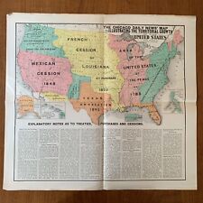 ~1899 The Chicago Daily News' Map Illustrating The Territorial Growth of the US
-
$3854.62 CAD
 1893 - Chicago & Alton RR Train Schedule Timetables - Antique Map - Rare
-
$17.88 CAD
 Rand McNally Chicago & Vicinity Illinois Map
-
$48.18 CAD
 Vintage Quaternary Geologic Map Chicago Quadrangle4 x 6 min USA 1983 1:1,000,000
-
$20.64 CAD
 1940'S CHICAGO MAP FOLD OUT TEXACO 32 INCHES TALL 22.5 WIDE LIGHT WEAR TEARS
-
$137.60 CAD
 1890 Rand McNally & Co Oklahoma Indian Territory Antique Map Chicago
-
$4818.28 CAD
 MAP OF COLORADO folding indexed pocket type RAND McNALLY cloth covers 1881
-
$61.95 CAD
 Folded Map Mineral Industries Illinois Chicago Decatur Springfield Joliet 1927
-
$12.39 CAD
 Rare National Geographic Folding Map of Illinois Copyright 1931 Free Ship! #5B
-
$14.45 CAD
 Rand-McNally City Road Map: CHICAGO & VICINITY, Illinois ©1997 with Index
-
$34.42 CAD
 1960's Chicago Tribune Advertising Map of Chicago


