 Antiques (CA)
-
$53.19 CAD

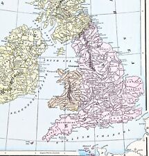 1898 British Isles Historical Map England Ireland Scotland Wales London
-
$53.19 CAD
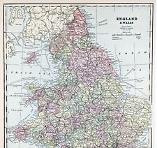 ENGLAND WALES Map 1889 ORIGINAL London Dover Railways Counties Townships G. CRAM
-
$42.58 CAD
 1780 Alexander Hogg Antique Print Plan of Dunnington Castle Berkshire, England
-
$564.28 CAD
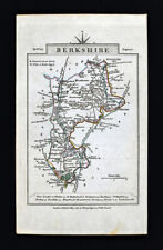
 1662 Joan Blaeu Antique Map of the English County of Berkshire
-
$38.26 CAD
 Vintage framed Hand Stitched Map Of England And Wales 20.5" x 16.5"
-
$30.09 CAD
 Somerset, Wiltshire, Berkshire & Hampshire - Original 1922 Ordnance Survey Map
-
$27.35 CAD
 1831 Lewis Map Bedfordshire Bedford Luton Shefford Ampthill Dunstable England UK
-
$43.76 CAD
 1814 John Cary Road Map Berkshire Windsor Park Reading Oxford Newbury England UK
-
$38.30 CAD
 1830 Nathan Hale Map England Wales London Liverpool Oxford Cornwall Bristol UK
-
$72.34 CAD
 1823 A. M. Perrot Antique Map, Oxfordshire, Berkshire, Buckinghamshire, Oxford,
-
$27.35 CAD
 1831 Lewis Map Berkshire Windsor Maidenhead Reading Oxford Newbury England UK
-
$27.35 CAD
 ANTIQUE 1775 BERKSHIRE ABINGTON MONMOUTH LONDON ENGLAND COPPERPLATE ROAD MAP NR
-
$13.68 CAD
 ELGAR'S BELOVED COUNTRY Booklet - By Michael Grundy - Elgar Route122523
-
$32.82 CAD
 1831 Lewis Map Berkshire Windsor Maidenhead Abingdon Oxford Newbury England UK
-
$21.89 CAD
 THAMES VALLEY Book - Colourmaster
-
$9.07 CAD
 Southern England: Hampshire, Berkshire, Surrey, Wiltshire, ... Sheet map, folded


