 Antiques (CA)
-
$130.23 CAD

 VERY NICE 1856 Colored Map - ST. LOUIS & CHICAGO - Colton's Atlas Of The World
-
$130.23 CAD
 VERY NICE 1856 Colored Map - PITTSBURGH & CINCINNATI - Colton's Atlas
-
$16.26 CAD
 1920 Color Maps by John Bartholomew of Physical Europe Map
-
$16.26 CAD
 1920 Color Maps Physical Indian Empire + Farther India and the East Indies Map
-
$13.71 CAD
 Sacramento Delta San Joaquin Atlas Map Spiralbound CA Water Resou 1995 Book Rare
-
$19.00 CAD
 1920 Color Maps Physical New Zealand & Tasmania, Old New Testament Palestine Map
-
$19.00 CAD
 1920 Color Maps Eastern Provinces of Canada and Physical North America Map
-
$24.35 CAD
 1912 Vintage Map India or Palestine Color Original From Hammond Atlas
-
$19.00 CAD
 1920 Color Maps Physical Features of Ireland and Scotland Map
-
$5.41 CAD
 Antique 1885 North America Map Canada, US from Cram’s Family Atlas World Indexed
-
$19.00 CAD
 1920 Color Maps Political United States and Physical South America Map
-
$19.00 CAD
 1920 Color Maps Physical Africa and British South Africa Map
-
$10.95 CAD
 National Geographic 1925 Map Of Washington DC. Approx 13 By 17 Inches. Frameable
-
$19.00 CAD
 1920 Color Maps Political England & Wales + Physical Scotland 2X pages Map
-
$16.26 CAD
 1920 Color Maps Physical Features of Switzerland and the Alps Map
-
$19.00 CAD
 1920 Color Maps Physical Australasia + Oceania Map
-
$24.35 CAD
 1912 Vintage Map Asia & Persia, Afghanistan Color Original From Hammond Atlas
-
$5.76 CAD
 Old atlas physical groups of the U.S., 8.5 x 11.
-
$24.35 CAD
 1912 Vintage Map Europe or Central Europe Color Original From Hammond Atlas
-
$19.00 CAD
 1920 Color Maps Physical Features Asia + North & South Polar Regions Map
-
$24.35 CAD
 1912 Vintage Map Italy or Spain& Portugal Color Original From Hammond Atlas
-
$24.35 CAD
 1912 Vintage Map Dominion of Canada Color Original From Hammond Atlas
-
$24.35 CAD
 1912 Vintage Map British Columbia Color Original From Hammond Atlas
-
$109.53 CAD
 Vintage Map Northern India Part Scale 1, 7, 500, 000 Political Coloring
-
$128.84 CAD
VERY NICE 1856 Colored Map - ST. LOUIS & CHICAGO - Colton's Atlas Of The World
-
$9.53 CAD
 1907 NEBRASKA or SOUTH DAKOTA Original Engraving, George Cram Atlas~ Towns Roads
-
$128.84 CAD
VERY NICE 1856 Colored Map - PITTSBURGH & CINCINNATI - Colton's Atlas
-
$9.53 CAD
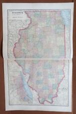 1907 ILLINOIS MAP in 2 Separate Sections, Original Engraving, George Cram Atlas
-
$27.40 CAD
 Sacramento Delta San Joaquin Atlas Map Spiralbound CA Water Resou 1995 Book Rare
-
$9.53 CAD
 1907 IOWA MAP, Original Engraving, George Cram Atlas~ Counties, Towns, Roads, RR
-
$114.81 CAD
 1933 MAP ATLANTIC OCEAN PHYSICAL COMMUNICATIONS BRITISH ISLES SOUTH AMERICA
-
$7.20 CAD
 Atlas Of North America - NATIONAL GEOGRAPHIC


