 Antiques (CA)
-
$130.01 CAD

 VERY NICE 1856 Colored Map - PITTSBURGH & CINCINNATI - Colton's Atlas
-
$41.06 CAD
 Antique colored map of Cincinnati, 1893 Columbian Atlas
-
$41.06 CAD
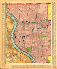
 Nice colored map of the Main Portion Cincinnati -Circa 1898 Atlas of the World
-
$44.46 CAD
 1867 Map Plan of Cincinnati, Ohio and Vicinity Mitchell Brothers Atlas Kentucky
-
$24.30 CAD
 1909 Vintage Map "Cincinnati" Color Map From Rand McNally Atlas
-
$34.14 CAD
 1898 Antique Map of Cincinnati Ohio OH Vintage Atlas Page
-
$17.72 CAD
 ORIGINL 1880 Mitchells New General Atlas COLORED MAP:ILLINOIS & CINCINNATI AREA
-
$34.05 CAD
 1857 J H COLTON , PITTSBURGH AND ALLEGHENY AND CINCINNATI OHO MAP , 13.8 X 17
-
$24.30 CAD
 1909 Vintage Map "Cincinnati Ohio" Color Original From Collier Atlas
-
$68.43 CAD
 1884 Gray's Atlas Map of Cincinnati, Kentucky, Tennessee, Louisville & Indy
-
$53.37 CAD
 Original 1879 Illinois Cincinnati Map Springfield,Mitchell IL Old Antique Ohio
-
$16.42 CAD
 19th Century Map Of Cincinnati Vintage Atlas United States
-
$24.30 CAD
 1919 Vintage Map Cincinnati Ohio B & W Original From Collier Atlas
-
$24.30 CAD
 1914 Vintage Map Cincinnati Ohio City B & W Original From Collier Atlas
-
$40.69 CAD
Nice colored map of the Main Portion Cincinnati -Circa 1898 Atlas World
-
$40.89 CAD
 1859 J H COLTON , PITTSBURGH AND ALLEGHENY AND CINCINNATI OHO MAP , 13.8 X 17
-
$40.69 CAD
Antique colored map of Cincinnati, 1893 Columbian Atlas
-
$128.84 CAD
VERY NICE 1856 Colored Map - PITTSBURGH & CINCINNATI - Colton's Atlas
-
$32.83 CAD
 Rand McNally Atlas of the World 1895 Cincinnati: 126 Year old Map
-
$65.67 CAD
 Plan of Cincinnati Ohio, Mitchell's General Atlas 1874 R9#60


