 Antiques (CA)
-
$85.99 CAD

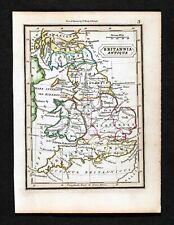
 1747 Roman Britain Original Antique Map by Richard Seale
-
$344.16 CAD
 1857 Huge 4-Panel Color Map . ENGLAND & WALES . Stanford - Original Antique Rare
-
$130.78 CAD
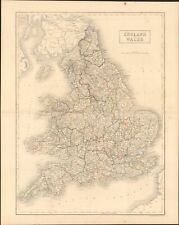
 Johnson's 1864 Large colored map of England and Wales
-
$38.60 CAD
 Vintage 1901 ENGLAND & WALES Map 14"x22" Old Antique Original CARDIFF LONDON
-
$137.67 CAD
 WALES CAERNARVONSHIRE 23.5” BLAEU 1640 ANTIQUE ORIGINAL COPPER ENGRAVED MAP.
-
$24.78 CAD
 England & Wales - Original 1905 Geological Map by Meyers Geologische Karte
-
$39.59 CAD
 Vintage 1901 ENGLAND & WALES UK Map 14"x22" Old Antique Original LONDON CARDIFF
-
$23.40 CAD
 England & Wales - Original 1903 Map by Dodd Mead & Company. Antique
-
$54.46 CAD
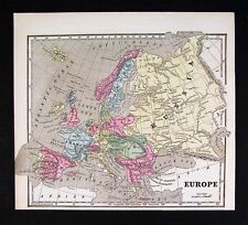
 Vintage 1900 EUROPE Map 11"x14" ~ Old Antique Original EU UK IRELAND SCOTLAND
-
$34.25 CAD
 OLD 1855 ENGLAND WALES SCOTLAND IRELAND Map Dublin London Aberdeen Orkney
-
$19.20 CAD
 Antique Map of ENGLAND WALES Map Wall Art Decor ca 1890 Vintage London
-
$28.91 CAD
 1898 British Isles Historical Map England Ireland Scotland Wales London
-
$69.33 CAD
 Vintage 1900 ENGLAND & WALES Map 14"x22" Old Antique Original BRITAIN UK LONDON
-
$550.66 CAD
 Antique Original 1645 Wales Irish Sea Map by Johannes (Joan) Blaeu Listed
-
$137.67 CAD
 Antique Johnson's Map Of England and Wales 1863 Civil War Era Old Map
-
$11.69 CAD
 GASKELL'S ATLAS MAP PAGES OF EUROPE - ENGLAND/WALES - ROMAN EMPIRE 1888
-
$24.78 CAD
 Western England & Wales - Original 1909 Map by John Bartholomew. Antique
-
$27.52 CAD
 1869 Antique Mitchell COLOR Map / GREAT BRITAIN AND IRELAND
-
$71.93 CAD
 1683 Manesson Mallet Antique Map Ilse D'Albion, Roman Britain, England, Scotland
-
$28.91 CAD
 1843 Europe Map Prussia Germany Iceland Ireland POLITICAL Russia Moscow Austria
-
$33.04 CAD
 1853 British Isles Map ORIGINAL England Wales Scotland Ireland London Dublin
-
$20.65 CAD
 Vintage Map of England & Wales on May 1, 1643 by Longmans Green 1905
-
$27.52 CAD
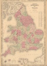
 1830 Original Sidney Hall Map - ENGLAND & WALES - Double-Sheet - Great Detail
-
$20.65 CAD
 Vintage Map of England & Wales 1660-1892 by Longmans Green 1914. Antique
-
$39.76 CAD
 1897 England and Wales Map Cornwall Dorsey Cardiff Portsmouth Hastings Bristol
-
$23.40 CAD
 England & Wales - Original 1891 Map by Hunt & Eaton. Antique
-
$68.80 CAD
 1683 Manesson Mallet Antique Map Royaume D'Angleterre, England, Wales, Scotland
-
$52.31 CAD
 ENGLAND WALES Map 1889 ORIGINAL London Dover Railways Counties Townships G. CRAM
-
$39.76 CAD
 OLD 1899 Southern England Wales Map London Cornwall STEAMSHIPS RAILWAYS PORTS
-
$64.37 CAD
 Vintage 1900 ENGLAND & WALES Map 14"x22" ~ Old Antique Original UNITED KINGDOM
-
$64.36 CAD
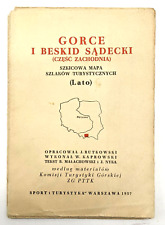 Vintage EUROPE Warsaw Map Mapa Sketch Map of Hiking Trails 1957
-
$34.64 CAD
 Vintage 1902 ENGLAND & WALES Map 11"x14" ~ Old Antique Original LEEDS LINCOLN
-
$30.29 CAD
 Merionethshire, Montgomery & Radnor, Wales. Original 1922 Ordnance Survey Map
-
$11.69 CAD
 CRAM'S ATLAS MAP PAGES OF EUROPE - ENGLAND & WALES 1890 VINTAGE
-
$22.03 CAD
 Southern England & Wales - Original 1902 Map by The Century Company. Antique
-
$34.40 CAD
 1832 Murphy Map Britannia Antiqua Britain England Wales Roman Londinum London UK
-
$23.40 CAD
 Northern England & Wales - Original 1902 Map by The Century Company. Antique
-
$41.29 CAD
 1831 Lewis Map Carnarvonshire Caernarfonshire Carnarvon Bangor Pwllheli Wales UK
-
$44.55 CAD
 Vintage 1900 ENGLAND WALES Map 11"x14" ~ Old Antique Original CAMBRIDGE LONDON
-
$137.67 CAD
 1873 Mitchell's Atlas County Map of England and Wales Authentic Hand-colored
-
$8.25 CAD
 Antique 1914 Old Atlas Map World War WWI Scotland + Edinburgh, England & Wales
-
$26.16 CAD
 Eastern England & Wales - Original 1909 Map by John Bartholomew. Antique
-
$30.29 CAD
 Pembrokeshire Carmarthenshire Cardigan - Large Original 1922 Ordnance Survey Map
-
$50.94 CAD
 1853 Europe Map ORIGINAL Turkey Russia Prussia Iceland Sardinia England Sweden
-
$137.67 CAD
 1767 Europe's Lakes, Rivers & Mountains antique map by Clouet ~ 22.7" x 16.6"
-
$75.06 CAD
 1683 Manesson Mallet Antique Map Heptarchie Des Saxons, Saxon Britain, England
-
$34.42 CAD
 1854 England & Wales by A.C. Black beautiful antique map 21.8" x 17.4
-
$28.91 CAD
 1899 Northern England Wales Map Liverpool Sheffield STEAMSHIPS RAILWAYS PORTS
-
$68.14 CAD
 1864 Map England and Wales County Map Antique Original Hand Colored Mitchell
-
$48.17 CAD
 1902 Johnston Oxford Map England Wales pre Norman Conquest Forts Battles London
-
$20.65 CAD
 Vintage Longmans Map of England in the Years 584 and 626 AD
-
$26.16 CAD
 Northern Part of England & Wales - Original 1896 Map by Velhagen & Klasing
-
$68.80 CAD
 1683 Manesson Mallet Antique Map Royaume D'Angleterre, England, Scotland, Wales
-
$48.17 CAD
 1814 John Cary Road Map Somerset Bristol Taunton Glastonbury Wells Bath England
-
$34.40 CAD
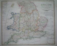
 Original 1834 Map ENGLAND & WALES Yorkshire Devon Oxford London Liverpool Exeter
-
$343.47 CAD
 Antique Map-South England and counties-London-Sussex-Kent-Wales-Sanson-ca. 1720
-
$48.17 CAD
 1838 Gilbert Antique Map England & Wales London Liverpool Oxford Great Britain
-
$49.50 CAD
 Vintage 1900 ENGLAND WALES Map 11"x14" ~ Old Antique Original UNITED KINGDOM
-
$20.64 CAD
 1942 Antique MAP of Hungary, foldrajzi zsebkonyv Magyar foldrajzi tarsasag, BP
-
$19.27 CAD
 Vintage Longmans Map of England & France in the Year 1259
-
$13.70 CAD
 1923 Orginial Antique Hammond Map of Netherlands & Belgium on rev. British Isles
-
$68.80 CAD
 1683 Manesson Mallet Antique Map Principaute de Galles, Wales
-
$17.70 CAD
 1903 Country Maps of Ireland and England & Wales Highly Detailed 10.5x13.5
-
$23.62 CAD
 Vintage 1902 ENGLAND & WALES Map 11"x14" ~ Old Antique Original CAMBRIDGE OXFORD
-
$23.47 CAD
 1942 Antique MAP of ENGLAND & WALES Map Vintage England Atlas Map 8955
-
$19.77 CAD
 Vintage 1900 SCOTLAND & ENGLAND Maps ~ Old Antique Original EDINBURGH LONDON UK
-
$27.53 CAD
 England & Wales - Original 1895 Map by W & A.K. Johnston. Antique
-
$17.19 CAD
 1853 Morse Map - Europe Austria France Germany Italy Spain Russia Great Britain
-
$41.29 CAD
 1831 Lewis Map Flintshire Flint Asaph Mold Caerwys Hawarden Salop County Wales
-
$23.40 CAD
 Great Britain - Original 1905 Map by Meyers. German Language Map. Antique
-
$27.53 CAD
 1864 England & Wales by Johnson Ward beautiful antique map 25.8" x 17.6"
-
$41.29 CAD
 1852 Antique Atlas Map / GREAT BRITAIN, IRELAND
-
$34.40 CAD
 1880 Antique Atlas Map / GREAT BRITAIN AND IRELAND
-
$22.03 CAD
 Southern England & Wales - Original 1897 Map by The Century Company. Antique
-
$23.40 CAD
 Northern England & Wales - Original 1897 Map by The Century Company, Antique
-
$34.40 CAD
 1831 Lewis Map Flintshire Flint St Asaph Mold Caerwys Holywell Hawarden Wales
-
$27.52 CAD
 1901 Antique Map / ENGLAND AND WALES
-
$34.40 CAD
 1831 Lewis Map Herefordshire Hereford Leominster Malvern Ledbury England UK
-
$23.40 CAD
 Southern England & Wales - Original 1902 Map by The Century Company. Antique
-
$27.53 CAD
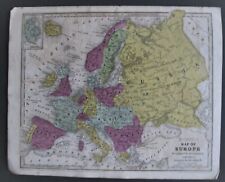
 1860 Europe antique map by Mitchell 15.3" x 12.3" - hand colored
-
$34.40 CAD
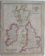 Original 1821 Map BRITISH ISLES England Scotland Ireland Wales Printed in Boston
-
$23.62 CAD
 Vintage 1900 BRITISH ISLES Map ~ Old Antique Original 11"x14" ENGLAND IRELAND
-
$34.40 CAD
 1921 Johnston Map Netherlands Belgium Luxemburg Holland Amsterdam Brussels Ghent
-
$23.73 CAD
 Vintage 1901 ENGLAND WALES Map 11"x14" ~ Old Antique Original CARDIFF OXFORD
-
$20.65 CAD
 Vintage Map of England & Wales on November 23, 1644 by Longmans Green 1905
-
$19.27 CAD
Vintage Map of England & Wales on May 1, 1643 by Longmans Green 1905
-
$123.83 CAD
 England and Wales old map by Rollos 1773
-
$20.65 CAD
 Vintage Map of England & Wales on December 9, 1643 by Longmans Green 1905
-
$34.40 CAD
 1880 Migeon Map - British Isles - England Wales Scotland London Great Britain UK
-
$34.40 CAD
 1921 Johnston Physical Map British Isles Great Britain England Ireland Scotland
-
$68.82 CAD
 1810 Delalain Map British Isles Great Britain England Wales Scotland Ireland
-
$34.40 CAD
 1921 Johnston Map South England Cornwall Lands End Devon Somerset Dorset Dexter
-
$55.05 CAD
 1844 Smith Map British Isles Great Britain England Scotland Ireland London Wales
-
$55.05 CAD
 1834 Carey Map British Isles England Wales Scotland Ireland London Britain UK
-
$72.26 CAD
 1823 ORIGINAL MAP UNITED KINGDOM ENGLAND WALES LONDON CAMBRIDGE LANCASTER YORK
-
$48.17 CAD
 1902 Johnston Oxford Map England Wales Anglia Sacra Church Divisions Edward I UK
-
$2064.98 CAD
 CARICATURE ANTIQUE MAPS 1868 by William Harvey aka ALEPH
-
$53.62 CAD
 Antique Original 1890 ENGLAND WALES Hunt & Eaton Colored Map 13x11 ~ Fisk & Co.
-
$344.16 CAD
 1798 Johann Probst Map Europe France England Germany Spain Holland Italy Sweden
-
$41.23 CAD
 1843 Smith Map Europe:Italian&German States,Prussia,Turkey&Russia +Folk Art Ship


