 Antiques (CA)
-
$39.76 CAD

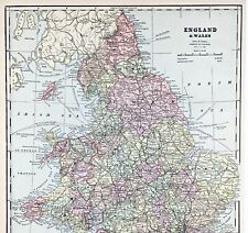
 1897 England and Wales Map Cornwall Dorsey Cardiff Portsmouth Hastings Bristol
-
$39.76 CAD
 OLD 1899 Southern England Wales Map London Cornwall STEAMSHIPS RAILWAYS PORTS
-
$33.67 CAD
 1835 J & C Walker Antique Map City Plan St Ives, Cornwall, England - Green Matt
-
$52.31 CAD
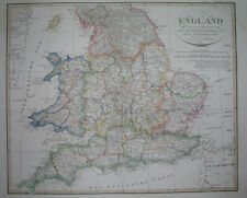
 ENGLAND WALES Map 1889 ORIGINAL London Dover Railways Counties Townships G. CRAM
-
$68.82 CAD
 1814 John Cary Road Map Cornwall Lands End Truro St. Ives Falmouth England UK
-
$52.15 CAD
 1889 Switzerland Map ORIGINAL Zurich Geneva Bern Cantons Townships Railroads
-
$103.25 CAD
 1876 British Isles antique map ~ 27.5" x 19.6" hand colored - Scotland & Ireland
-
$17.19 CAD
 1892 Crowell Kirkpatrick Map - England & Wales London Liverpool Bristol Cornwall
-
$34.64 CAD
 Vintage 1900 IRELAND Map 11"x14" ~ Old Antique Original DONEGAL DUBLIN GALWAY
-
$72.26 CAD
 1823 ORIGINAL MAP UNITED KINGDOM ENGLAND WALES LONDON CAMBRIDGE LANCASTER YORK
-
$52.99 CAD
 1838 nice ORIGINAL MAP UNITED KINGDOM ENGLAND WALES LONDON CARDIFF MANCHESTER
-
$48.18 CAD
 1830 Nathan Hale Map England Wales London Liverpool Oxford Cornwall Bristol UK
-
$71.48 CAD
 1823 A. M. Perrot Antique Map, Cornwall, England
-
$34.40 CAD
 1830 Nathan Hale Map - England & Wales - London Liverpool Cornwall Dover Bristol
-
$47.48 CAD
 1848 nice ORIGINAL MAP UNITED KINGDOM ENGLAND WALES LONDON LIVERPOOL CARDIFF
-
$79.14 CAD
 1823 ORIGINAL MAP IRELAND UNITED KINGDOM ENGLAND WALES SCOTLAND DUBLIN LONDON
-
$34.42 CAD
 1876 British Isles map antique ~ 17.3" x 13.8" hand color & US Census maps
-
$136.29 CAD
 1840 British Isles map by Greenleaf 14.2" x 11.9" scarce 1st edition antique
-
$103.25 CAD
 1876 Europe antique map ~ 27.5" x 19.5" hand colored - large - ships
-
$16.85 CAD
 Attractive 1920s atlas map of France and Belgium
-
$268.45 CAD
 1780 Kingdoms of England Scotland & Ireland antique map by Bonne/Lattre - framed


