 Antiques (CA)
Africa Maps
Asia Maps
Australia/Oceania Maps
Celestial Maps
Central America/Caribbean Maps
Curiosities Maps
Digital Maps
Europe Maps
Map & Globe Mixed Lots
Map & Globe Reproductions
North America Maps
South America Maps
World & Celestial Globes
World Maps

-
$526.66 CAD

 1744 Georg Mattaus Seutter Antique Map of Africa
-
$280.25 CAD
 1773 Bellin, map, Hudson Bay, Canada, James BAY, Labrador
-
$135.43 CAD
 1812 Lapie Map of Great Britian Scotland and Ireland
-
$129.96 CAD
 Cape of Good Hope South Africa Bellin Map 1773 Carte de la Baye de la Table
-
$341.99 CAD
 1767 Armillary Sphere poles tropics + more antique map by Clouet ~ 22.5" x 16.9"
-
$41.04 CAD
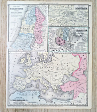 Mitchell 1875 Map Palestine Holy Land Jerusalem Barbarians Roman Empire
-
$121.75 CAD
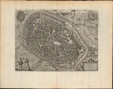 c 1613 Mons Belgium antique map ~ 17" x 13.2" by Guicciardini / Blaeu
-
$341.99 CAD
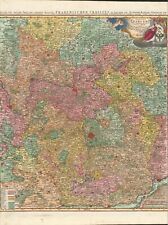 1735 Franconia Bavaria antique map by Homann ~ 24.7" x 21.2" beautiful color
-
$177.82 CAD
 Antique Map - Joseph Roux - Harbour Plan - Saint-Drely Bay in Turkey - F5
-
$341.99 CAD
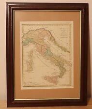 1815 Italy of antiquity by R. Wilkinson - beautiful antique framed map - London
-
$38.30 CAD
 1831 Spain / Catalonia antique map SDUK engraved by J C Walker
-
$47.88 CAD
 1795 Guthrie Hindostan or India - 9.9" x 8.3" Authentic & original antique map
-
$54.70 CAD
 1839 Stieler Physical Map Europe River Basins Mountain Ranges Rhine Danube Seine
-
$163.32 CAD
 1816 Map of Switzerland, copper engraving with hand colour, 30.5 x 42 cm
-
$227.18 CAD
 1780 Bonne - Spain & Portugal - hand coloured engraved map
-
$170.99 CAD
 Antique Map Switzerland According to the Best Authorities Carey 1795 Engraving
-
$95.76 CAD
 1820 Ancient Greece antique map by Lavoisne ~ 21.8" x 17.5" hand colored
-
$246.23 CAD
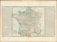
 FRANCE 1770 PHILIPPE BUACHE LARGE ANTIQUE PHYSICAL MAP 18TH CENTURY
-
$41.04 CAD
 1795 Guthrie Ireland - 9.2" x 8.2" Authentic & original antique map
-
$239.39 CAD
 1735 Austria & more antique map by Homann ~ 24.8" x 21.1" beautiful color
-
$136.78 CAD
 Antique Map - Joseph Roux - Harbour Plan - Port of Parenso-Croatia - Pula - F5
-
$41.04 CAD
 1795 Guthrie Germany - 10" x 8.5" Authentic & original antique map
-
$136.78 CAD
 Antique Map - Joseph Roux - Harbour Plan - Port of Saint Antoine - Lemnos - F5
-
$65.66 CAD
 1892 Stieler World Map - North Pole Arctic Ocean Greenland Canada Siberia Alaska
-
$95.69 CAD
 Spain Portugal Physical Geography Map by Mentelle 1767
-
$615.58 CAD
 1749 Formosa / Taiwan antique map by Bellin / Schley ~ 18.7" x 11.7" China rare
-
$170.99 CAD
 1830 Pacific Ocean - islands coasts & US antique map by Huntington ~ 11" x 8.25"
-
$88.92 CAD
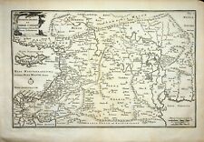
 1767 Lower Rhine Westphalia antique map by Clouet ~ 22.7" x 17.1" - hand color
-
$323.37 CAD
 1757 J. Bellin - Carte des Îles Malouines - Map of FALKLAND ISLANDS
-
$57.80 CAD
 1825 John Russell Antique Map of Scotland
-
$2667.50 CAD
 Map California, Territories of Oregon, Washington, Utah, New Mexico DeSilver1859
-
$190.10 CAD
 1773 Bellin Rare Krevelt issue DEMERARA & ESQUIBO RIVER GUYANA
-
$307.79 CAD
 1735 Duchy Luxembourg antique map by Homann ~ 25" x 20" beautiful full color
-
$102.60 CAD
 1767 Kingdom of Hungary antique map by Clouet ~ 22.8" x 17.1" - hand color
-
$102.60 CAD
 c1700 Paradise, Canaan, Babylon & Garden Eden by Halma ~ 14.7" x 10" Antique map
-
$88.92 CAD
 1767 British Isles / England antique map by Clouet ~ 22.7" x 16.7" - hand color
-
$177.82 CAD
 Antique Map - Joseph Roux - Harbour Plan - Port of Ancona in Italy - F5
-
$136.78 CAD
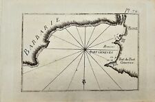 Antique Map - Joseph Roux - Harbour Plan - Boun Algiers and Port Geneva - F5
-
$232.54 CAD
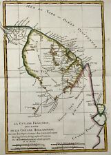 1780 Map of northeastern South America, depicting Guyana (Guyane), Bonne
-
$1316.65 CAD
 1755 (1768) De Vaugondy Large 2nd edition Antique Map of Colonial United States
-
$157.31 CAD
 1767 South America antique map by Clouet ~ 23.1" x 17.1" - Hand Colored
-
$205.18 CAD
 Antique Map - Joseph Roux - Strait of Bonifacio - Corsica & Sardinia - F5
-
$205.18 CAD
 Antique Map - Joseph Roux - Harbour Plan - Port of Syracuse / Saragosa - F5
-
$135.43 CAD
 1729 Canary Islands map by Robert Vaugondy - circa 1750 -
-
$164.15 CAD
 Artesia (Belgium/Northern France) Antique Engraved Map M. Seutter 18th Century
-
$177.82 CAD
 Antique Map - Joseph Roux - Harbour Plan - Constantinople Bosphorus Canal - F5
-
$88.92 CAD
 1820 Germany antique map by Lavoisne / Carey 21.8" x 17.5" hand color
-
$239.39 CAD
 1743 Konstanz Württemberg Swabia + antique map by Homann ~ 25" x 20" full color
-
$41.04 CAD
 c1720 Spain & Portugal 9" x 7.6" Authentic & original antique map
-
$61.56 CAD
 1795 Guthrie Poland Showing Claims 10.1" x 8.4" Authentic & original antique map
-
$123.12 CAD
 c1744 Belgium by M. Seutter - Germaniae Inferioris sive Belgii - antique map
-
$116.28 CAD
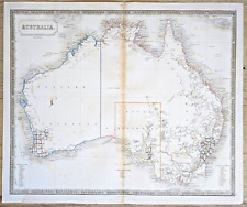 Australia Antique Map circa 1850 by Sidney Hall Engraved Outline Color
-
$27.35 CAD
 1873 Steinwehr Physical World Map Mountains Plateaus Plains America Europe Asia
-
$682.61 CAD
 Antique Original Blaeu Map of Africa. Regna Congo et Angola. Elephants & Rhinos
-
$225.71 CAD
 A Map of the Seat of War in France 1795 Mathew Carey Belgium Germany Engraving
-
$88.92 CAD
 1767 "Commercante" France antique map by Clouet ~ 22.7" x 17.1" - hand color
-
$136.79 CAD
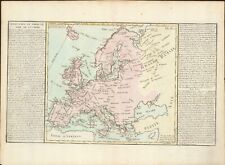
 1767 Europe's Lakes, Rivers & Mountains antique map by Clouet ~ 22.7" x 16.6"
-
$239.39 CAD
 1767 World Hemispheres latest observations antique map by Clouet ~ 22.7" x 16.3"
-
$157.31 CAD
 1767 Kingdom of Poland antique map by Clouet ~ 22.8" x 17.1" hand color
-
$88.92 CAD
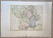
 1767 General France antique map by Clouet ~ 23" x 17.1" - hand color
-
$272.22 CAD
 1735 Saxony Germany antique map by Homann ~ 25" x 20" beautiful full color
-
$88.92 CAD
 1767 General Spain antique map by Clouet ~ 23" x 17.1" - hand color
-
$123.12 CAD
 1767 Asia - Arabia to China antique map by Clouet ~ 23.1" x 17.1" - hand color
-
$102.60 CAD
 1767 General map of France antique map by Clouet ~ 22.9" x 16.6" - hand color
-
$136.79 CAD
 1767 Europe's Islands Capes & Seaports antique map by Clouet ~ 23" x 16.8"
-
$157.31 CAD
 1767 Mongol Empire / India antique map by Clouet ~ 22.8" x 17.1" - hand color
-
$61.56 CAD
 1780 Europe by Raynal / Bonne 14.1" x 9.75" authentic antique map
-
$88.92 CAD
 1767 Switzerland antique map by Clouet ~ 23" x 16.6" - hand color
-
$108.34 CAD
 c 1650 MERIAN Antique Map Blavet River Port Louis Citadel Fort Brittany France
-
$102.60 CAD
 1767 Ecclesiastical France antique map by Clouet ~ 22.6" x 16.6" - hand color
-
$88.92 CAD
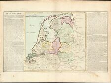 1767 Holland antique map by Clouet ~ 22.7" x 16.8" - hand color
-
$41.02 CAD
 1795 Guthrie Northern Russia - 9.5" x 8.1" Authentic & original map Muscovy
-
$88.92 CAD
 1767 Sweden Norway & Denmark antique map by Clouet ~ 22.8" x 16.8" hand color
-
$136.79 CAD
 1767 Swabia & Bavaria Germany antique map by Clouet ~ 23.1" x 17.1" - hand color
-
$21.89 CAD
 1860 Johnson Map - World Animal Kingdom Birds - Productive Industry Agriculture
-
$109.44 CAD
 1820 Asia China India Mongol + antique map by Lavoisne 21.8" x 17.6" hand color
-
$68.40 CAD
 1820 Hindostan / India by Warner & Cary - 8.8" x 8.2" Authentic & original map
-
$95.76 CAD
 1820 China & Korea antique map by Lavoisne 21.8" x 17.6" hand color
-
$47.88 CAD
 1820 South America - original engraved map by Blondeau, Amérique Méridionale
-
$32.82 CAD
 1892 Stieler Map North South Dakota Nebraska Minnesota Iowa United States Canada
-
$272.22 CAD
 1735 Mosellae Fluminis antique map by Homann ~ 25" x 20" beautiful full color
-
$123.12 CAD
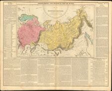 1820 Empire of Russia antique map by Lavoisne 21.8" x 17.6" hand color
-
$123.12 CAD
 1767 Barbary North Africa antique map by Clouet ~ 22.6" x 16.3" hand colored
-
$116.28 CAD
 1820 South America antique map by Lavoisne / Carey 21.6" x 17.3" hand color
-
$41.04 CAD
 1795 Guthrie Netherlands - 9.7" x 7.9" Authentic & original antique map
-
$88.92 CAD
 1767 Provinces of Spain antique map by Clouet ~ 22.6" x 17.1" - hand color
-
$307.79 CAD
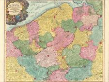 1735 Flanders Belgium antique map by Homann ~ 25" x 20" beautiful full color
-
$123.12 CAD
 1767 Egypt antique map by Clouet ~ 22.8" x 17.1" hand colored
-
$150.47 CAD
 1820 India Hindoostan antique map by Lavoisne / Carey 21.8" x 17.6" hand color
-
$47.88 CAD
 1795 Guthrie 7 United Provinces Netherlands 9.7" x 8.3" Authentic & original map
-
$88.92 CAD
 1767 Mineralogical France antique map by Clouet ~ 22.8" x 16.7" - hand color
-
$60.86 CAD
 1856 NICE ORIGINAL MAP World Eastern Hemisphere ASIA EUROPE AUSTRALIA AFRICA
-
$75.24 CAD
 1820 Canaan & Egypt antique map by Lavoisne ~ 21.8" x 17.5" hand colored
-
$341.99 CAD
 1735 Map of Postal Routes of Germany by Homann ~ 23.6" x 20"
-
$136.79 CAD
 1750 Plan of Cardona by Basire 20.7" x 15.5" - scarce antique map Catalan
-
$88.92 CAD
 1767 Turkey in Europe antique map by Clouet ~ 22.8" x 17.1" - hand color
-
$47.88 CAD
 1795 Guthrie Switzerland - 10.2" x 8.5" Authentic & original antique map
-
$123.12 CAD
 1820 Poland & Hungary antique map by Lavoisne 21.8" x 17.6" hand color
-
$33.46 CAD
 1825 Sydney Hall Antique Map of Africa
-
$83.66 CAD
 1817 Aaron Arrowsmith Antique Map of South America


