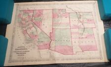
 Antiques (CA)
-
$68.24 CAD

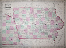
 Johnson's Iowa Nebraska Hand Colored Map 1864 B21
-
$54.60 CAD
 Johnson's Family Atlas Map Of Illinois 1867
-
$23.21 CAD
 Iowa - Original 1896 Copper-Plate Map by AJ Johnson. Antique
-
$24.57 CAD
 Original 1896 Copper-Plate Map of Minnesota by A. J. Johnson. Antique
-
$47.76 CAD
 Rare 1855 MARYLAND & DELAWARE Map w/ Colored Counties ~ 18" X 14", Johnson Map
-
$121.49 CAD
 1864 CALIFORNIA, AZ, NV, UT, CO, NM Map, Colored Historical Civil War Era 26x18"
-
$66.89 CAD
 1865 MINNESOTA Map w/ Colored Counties ~ Historical Civil War Era, 18"x13.5"
-
$92.82 CAD
 1865 Map LOUISANA, MISSISSIPPI, ARKANSAS, Historical Civil War Era 26x18"
-
$28.23 CAD
 Old 1880 Johnson's Atlas Map ~ GEORGIA - ALABAMA ~ Free S&H
-
$80.54 CAD
 1862 Johnson Minnesota & Dakota antique map 17.2" x 14" nice color
-
$21.83 CAD
 1896 Johnson Map Idaho Boise City McKenzie Challis Moscow Bitter Root Mountains
-
$511.89 CAD
 1862 Johnson California Southwest Territory antique map 26.1" x 18.7" nice color
-
$92.82 CAD
 1862 Vicinity of RICHMOND Map, Peninsula Campaign VIRGINIA, Historical 26" x 18"
-
$409.51 CAD
 1867 Johnson's California, with Utah, Nevada, Colorado, New Mexico and Arizona
-
$39.26 CAD
 Vintage 1896 QUEBEC & NEW BRUNSWICK CANADA Map 10"x7" ~ Old Antique Original
-
$23.21 CAD
 Missouri - Original 1896 Copper-Plate Map by AJ Johnson. Antique
-
$129.68 CAD
 1862 Johnson Dakota Nebraska Kansas Colorado antique map 17.4" x14.2" nice color
-
$92.82 CAD
 1863 GEORGIA & ALABAMA Map, Colored Counties RR Historical Civil War Era 26"x18"
-
$16.38 CAD
 1896 Johnson Map - Iowa - Des Moines City - Council Bluffs Keokuk Burlington IA
-
$62.72 CAD
 Old 1880 Johnson's Atlas Map ~ OHIO ~ Free S&H
-
$13.65 CAD
 1894 NEBRASKA MAP HAND COLORING JOHNSON
-
$102.38 CAD
 1862 Johnson Virginia PA DE MD antique map 26.6" x 18.1" nice color - Richmond
-
$28.23 CAD
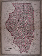 Old 1873 Johnson's Atlas Map ~ ILLINOIS ~ Free S&H
-
$45.73 CAD
 Original 1894 Antique Map ALABAMA Auburn Opelika Dothan Tuscaloosa Mobile Athens
-
$28.23 CAD
 Old 1880 Johnson's Atlas Map ~ ILLINOIS ~ Free S&H
-
$61.43 CAD
 1862 Johnson's Missouri and Kansas Map Johnson & Ward Antique
-
$75.08 CAD
 1862 Johnson Kentucky & Tennessee antique map 24.7" x 17.9" nice color
-
$61.43 CAD
 1862 Johnson's New York Map Johnson & Ward Illustrated Family Atlas Antique
-
$477.77 CAD
 1864 Johnson's California with territories of Utah, Nevada, Colorado, New Mexico
-
$24.57 CAD
 Kentucky - Original 1896 Copper-Plate Map by A. J. Johnson. Antique
-
$23.21 CAD
 Illinois - Original 1895 Copper-Plate Map by A. J. Johnson. Antique
-
$24.57 CAD
 Ohio - Original 1895 Copper-Plate Map by A. J. Johnson. Rare.. Antique
-
$62.72 CAD
 Old Antique 1868 Johnson Atlas Map ~ RICHMOND, VIRGINIA ~ Free S&H
-
$204.74 CAD
 1866 UNITED STATES CAPITOL VIEW, ANTIQUE ORIGINAL ENGRAVING PUBL BY AJ JOHNSON
-
$28.23 CAD
 Old 1873 Johnson's Atlas Map ~ OHIO ~ Free S&H
-
$62.72 CAD
 Old 1880 Johnson's Atlas Map ~ MINNESOTA ~ Free S&H
-
$45.03 CAD
 Rare 1867 NEW JERSEY Map w/ Colored Counties ~ 17 3/8" x 13 5/8", AJ Johnson Map
-
$62.72 CAD
 Old Antique 1868 Johnson Atlas Map ~ MARYLAND - DELAWARE ~ Free S&H
-
$21.83 CAD
 1896 Johnson Map - Georgia - Atlanta Savannah Athens Dalton Macon Columbus GA
-
$27.29 CAD
 1863 Johnson Map - New Hampshire & Vermont - Montpelier Concord Mt. Washington
-
$58.68 CAD
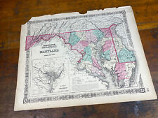 1865 MARYLAND & DELAWARE Map, Colored Counties Historical Civil War Era, 18"x14"
-
$54.60 CAD
 Johnsons Family Atlas Map Of Ohio 1867
-
$88.73 CAD
 1862 Johnson New York with many insets antique map 26.1" x 17.8" nice color
-
$68.24 CAD
 1865 WASHINGTON & OREGON Map, Colored Counties Historical Civil War Era 18"x13"
-
$375.39 CAD
 1862 Johnson Texas antique map 25.6" x 18.6" nice color - Galveston, Sabine Lake
-
$109.20 CAD
 Johnson's Family Atlas Map Of North America 1867
-
$45.03 CAD
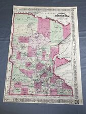 Rare 1865 MINNESOTA Map w/ Colored Counties ~ 17 3/4" x 12 1/4", A.J.Johnson Map
-
$129.68 CAD
 Johnson's Map of New York and the Adjacent Cities 1862
-
$37.06 CAD
 Old Antique 1868 Johnson Atlas Map ~ IOWA - NEBRASKA ~ Free S&H
-
$21.84 CAD
 1896 Johnson Map - Mississippi - Jackson Biloxi Natchez Vicksburg Oxford MS
-
$28.23 CAD
 Old 1873 Johnson's Atlas Map ~ LOUISIANA - MISSISSIPPI - ARKANSAS ~ Free S&H
-
$92.82 CAD
 1865 MICHIGAN & WISCONSIN Map, Colored Counties Historical Civil War Era 26"x18"
-
$28.23 CAD
 Old 1873 Johnson's Atlas Map ~ PENNSYLVANIA - NEW JERSEY ~ Free S&H
-
$88.73 CAD
 Johnson's North And South Carolina 1862 Map Johnson and Ward Illustrated Atlas
-
$66.89 CAD
 1862 Johnson state of New Jersey antique map 16.6" x 14" nice color
-
$61.43 CAD
 1862 Johnson Iowa & Nebraska antique map 17.6" x 14.2" nice color
-
$16.37 CAD
 1896 Johnson Map - New Hampshire - Concord Portsmouth Amherst Mount Washington
-
$62.72 CAD
 Old 1880 Johnson's Atlas Map ~ KENTUCKY - TENNESSEE ~ Free S&H
-
$62.72 CAD
 Old 1880 Johnson's Atlas Map ~ WASHINGTON - GEORGETOWN ~ Free S&H
-
$95.49 CAD
 Rare 1864 Map of Pennsylvania & New Jersey ~ Waterways, Railroads, Townships
-
$66.89 CAD
 1862 Johnson Maryland Delaware DC & insets antique map 17.5" x 14.1" nice color
-
$54.60 CAD
 Johnson's Family Atlas Map Of Pennsylvania & New Jersey 1867
-
$102.38 CAD
 1862 Johnson Alabama & Georgia antique map 26.1" x 18.1" nice color
-
$28.23 CAD
 Old 1873 Johnson's Atlas Map ~ NEW HAMPSHIRE - VERMONT ~ Free S&H
-
$62.72 CAD
 Old Antique 1868 Johnson Atlas Map ~ MISSOURI - KANSAS ~ Free S&H
-
$203.39 CAD
 1862 Johnson Washington & Oregon antique map 17.2" x 14" nice color
-
$54.60 CAD
 Johnson's Family Atlas Map Of North & South Carolina 1867
-
$95.49 CAD
 Rare 1864 Large Map of NEW YORK, Johnson & Ward, Waterways, Railroads, Townships
-
$45.03 CAD
 Rare 1867 ILLINOIS Map w/ Colored Counties ~ 24.25" x 17.75" ~ A.J. Johnson Map
-
$62.72 CAD
 Old 1880 Johnson's Atlas Map ~ VIRGINIA - WEST VIRGINIA ~ Free S&H
-
$62.72 CAD
 Old 1873 Johnson's Atlas Map ~ KENTUCKY - TENNESSEE ~ Free S&H
-
$50.51 CAD
 Rare 1867 PENNSYLVANIA & NEW JERSEY Colored County Map, A.J. Johnson, 25" x 18"
-
$68.24 CAD
 1864 IOWA & NEBRASKA MAP Colored Counties, RR, Historical Civil War Era 26x18"
-
$102.38 CAD
 1862 Johnson Massachusetts Rhode Island CT antique map 26" x 17.8" nice color
-
$62.72 CAD
 Old 1873 Johnson's Atlas Map ~ MINNESOTA ~ Free S&H
-
$102.38 CAD
 1862 Johnson New Hampshire & Vermont antique map 26.2" x 18" nice color
-
$62.72 CAD
 Old 1868 Johnson Atlas Map ~ GEORGIA - ALABAMA ~ Free S&H
-
$54.60 CAD
 Johnson's Family Atlas Missouri & Kansas
-
$54.60 CAD
 Johnson's Family Atlas Map Of Vermont, New Hampshire, Mass., RI, &...
-
$62.72 CAD
 Old 1873 Johnson's Atlas Map ~ WASHINGTON TERRITORY - OREGON ~ Free S&H
-
$54.60 CAD
 Johnson's Family Atlas Map Of Delaware & Maryland 1867
-
$54.60 CAD
 Johnson's Family Atlas Map Of Kentucky & Tennessee 1867
-
$47.76 CAD
 Rare 1867 IOWA & NEBRASKA Map w/ Colored Counties ~ 23 3/4" x 17 1/2"
-
$47.76 CAD
 1867 Map ~ MASSACHUSETTS, CONNECTICUT, RHODE ISLAND ~ A.J. Johnson, 24" x 17"
-
$54.60 CAD
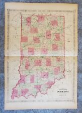 Johnson's Family Atlas Map Of Indiana 1867
-
$40.95 CAD
 Johnson's Family Atlas Map Of Switzerland 1867
-
$54.60 CAD
 Johnson's Family Atlas Map Of Georgia & Alabama 1867
-
$54.60 CAD
 Johnson's Family Atlas Map Of Maine 1867
-
$54.60 CAD
 Johnson's Family Atlas Map Of New Brunswick, Nova Scotia & Newfoundland 1867
-
$68.25 CAD
 Johnson's Family Atlas Map Of New York 1867
-
$54.60 CAD
 Johnson's Family Atlas Map Of New Jersey 1867
-
$68.25 CAD
 Johnsons Family Atlas Oregon, Washington, Minnesota 1867
-
$68.25 CAD
 Johnson's Family Atlas Wisconsin & Michigan
-
$68.25 CAD
 Johnson's Family Atlas Map Of Arkansas, Mississippi & Louisiana 1867
-
$136.44 CAD
 1929 DYKER BEACH BROOKLY NY BAY 8TH-SHORE PKWY & INDEPENDENCE-17TH AV ATLAS MAP
-
$54.60 CAD
 Johnsons Family Atlas Iowa & Nebraska
-
$204.76 CAD
 1864 Johnson’s Map Of Wisconsin & Michigan Alvin Johnson 17.5 x 24.75” Colored
-
$54.60 CAD
 Johnson's Family Atlas Map Of Massachusetts, Connecticut & Rhode Island 1867
-
$238.88 CAD
 1864 Johnson’s Map Of Oregon, Washington & Minnesota Alvin Johnson 17.5 x 24.75”
-
$102.38 CAD
 Rare 1864 Large Map of NEW YORK, Johnson & Ward, Waterways, Railroads, Townships


