 Antiques (CA)
-
$136.84 CAD

 Sheet Number 64 Map, Anglers-Orleans 28x46" WW2 Army Service Map 1942 France
-
$54.71 CAD
 1944 Nautical Chart Map #1247 Bethel Shoal to Jupiter Inlet Florida 34" x 47"
-
$171.06 CAD
 1941 Nautical Chart Hilo Bay Hawaii Restricted WWII 25" x 27" #4103
-
$20.53 CAD
 Vintage English Map of Motoring and Hiking Routes-1940's
-
$143.69 CAD
 1945 4th Armored Division (Name Enough), Route of the 4th Armored WWII Map
-
$102.61 CAD
 1945 Nautical Chart Map Northwest Pacific Ocean Japan Hawaii Russia Restricted
-
$129.95 CAD
 WWII 1941-1942 German Millitary Invasion Ukraine Map Europaisches Russland
-
$20.51 CAD
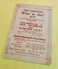 Vintage 1940's RIVER THAMES Westminster England FERRY SCHEDULE Map & Fares Slip
-
$61.58 CAD
 1943 US Navy Nautical Map England Southeast Coast Folkestone Harbour 4503 22x28"
-
$29.08 CAD
 Ordinance Survey 1/4 Inch Map of Great Britain 1946 England South-West Sheet 10
-
$123.10 CAD
 1934 Nautical Chart #3831 Bismark Archipelago New Guinea & New Britain 30" x 42"
-
$61.58 CAD
 1951 Hydrographic Nautical Chart Port Royal to Pedro Bluff Jamaica 30 x 50" 1683
-
$409.18 CAD
 First Post II World War map of Poland, April 1945


