 Antiques (CA)
-
$27.88 CAD

 c1930 Antique MANITOBA Canada Picture Map Vintage Animated Map of Manitoba 5861
-
$110.13 CAD
 Vintage 1937 Soundings in Fathoms Map Canada British Columbia Hecate Strait
-
$34.28 CAD
 1931 - British North America (Canada) - Vintage Map ORIGINAL 11.5 x 9.5"- C11-2
-
$16.86 CAD
 Map Saskatchewan And Manitoba Canada 1938 Print Antique Ephemera DWU8
-
$34.99 CAD
 Yukon Carmacks Area Geological Map-1936 Dept. Mines 24" X 23" Gold Prospecting
-
$34.99 CAD
 Pelly River Yukon Geological Map - 1936 Dept. Mines 29" X 17" Gold Prospecting
-
$8.25 CAD
 Great OLD Vintage 1936 OLD World Pre War WWII City Map Montreal, Quebec, Canada
-
$108.76 CAD
 1932 CITY QUEBEC CANADA Color Map HISTORICAL notes-S H Maw NOT A RECENT REPRINT
-
$20.64 CAD
 1937 Map Toronto Ontario Canada City Plan Riverside Queen's Park Yonge Street
-
$20.64 CAD
 Vintage 1934 Outdoor in New Brunswick Canada Government Book Photographs
-
$185.85 CAD
 1913 Edition Reprinted 1930 Niagara Gorge Color Map 22" x 48" U.S & Canada
-
$17.19 CAD
 1938 Atlas Map Montreal Plan Quebec Canada St. Lawrence River Downtown Parks
-
$13.70 CAD
 Vintage 1934 National Topographic Series Map of Shuswap British Columbia
-
$24.78 CAD
 1937 Antique Animated MANITOBA Picture Map Cartoon Map of Manitoba Canada 5519
-
$16.86 CAD
 Map Quebec Canada And Coastal Labrador 1938 Print Antique Ephemera DWU8
-
$24.09 CAD
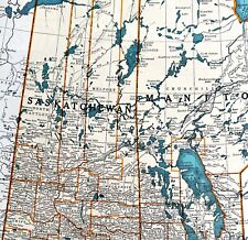 Saskatchewan Manitoba Canada Map 1935 Provinces Hudson Bay 14 x 11" LGAD99
-
$121.08 CAD
 1938 Navigational Notes Labrador Coast Forbes with 6 Maps
-
$20.64 CAD
 1937 McNally Map Canada British Columbia Alberta Vancouver Victoria Banff NP CA
-
$20.64 CAD
 Original 1937 Map YUKON TERRITORY Dawson Whitehorse Railroad Telegraph Canada
-
$20.64 CAD
 1937 McNally Map Canada Quebec City Montreal Ottawa Trois Rivieres St. Lawrence
-
$19.08 CAD
 1939 City Map of Central Section Of Montreal Canada Highly Detailed
-
$19.08 CAD
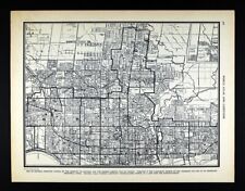
 1939 City Map of Central Toronto Canada Ontario Highly Detailed
-
$27.53 CAD
 1936. VINTAGE FOLDING MAP. NORTH AMERICA. CANADA.
-
$16.86 CAD
 Map Dominion Of Canada And Newfoundland 1938 Print Antique Ephemera DWU8
-
$13.75 CAD
 Large-Format 1936 Map CANADA Highways Railroads Steamship Routes Moose Factory
-
$17.88 CAD
 SOUTHEASTERN ONTARIO, CANADA - 1933 Color Map
-
$21.74 CAD
 1935 Antique Map J Thomas Co Quebec Manitoba Alberta Ontario
-
$19.27 CAD
 Porter District of Sudbury Ontario 1935 Map
-
$17.19 CAD
 1938 Collier Antique Map Toronto City Plan Ontario Canada Downtown Park Landmark
-
$20.64 CAD
 1937 McNally Map Canada Ontario Quebec Manitoba Alberta British Columbia Yukon
-
$16.51 CAD
 Dominion of CANADA & NEWFOUNDLAND Vintage COLOR MAP 1935
-
$41.30 CAD
 1930 Car Auto Roads Between Canada & USA Atlantic Sheet Map Large Color
-
$16.52 CAD
 vintage 1939 atlas map of Montreal 11x14 inches black and white ready to frame
-
$52.30 CAD
 Vintage 1934 Rand McNally Map of Canada and Newfoundland ~ Color
-
$16.52 CAD
 vintage 1939 atlas map of Toronto Canada 11 x 14 inches black & white
-
$34.40 CAD
 Antique Framed Yukon Canada 1937 Map 11 x 14 Rand McNally
-
$15.13 CAD
 MANITOBA, Canada - Vintage 1930 Color Map Print
-
$16.52 CAD
 vintage 1939 atlas map of Canada & Newfoundland 2 sided Nova Scotia New Brunswic
-
$11.01 CAD
 Vintage Source for Canadian Geological Maps by Province 1936!
-
$27.52 CAD
 Vtg 30s HUDSON MAP Co. Colored MAP of CANADA Mines Forests Survey Railways 36x25
-
$17.88 CAD
 NOVA SCOTIA, NEW BRUNSWICK & PRINCE EDWARD ISLAND - 1933 Color Map
-
$34.40 CAD
 Antique Framed Oregon 1937 Map 11 x 14 Rand McNally
-
$34.40 CAD
 Antique Framed Minnesota 1937 Map 11 x 14 Rand McNally
-
$41.29 CAD
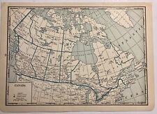
 Vintage~ 1936 Province Of Canada~ Wall Map


