 Antiques (CA)
-
$28.99 CAD

 Antique Minneapolis St Paul Street Map from Atlas 1920s 1921
-
$14.02 CAD
 Antique Colorful 1923 Map Of Minnesota 9x6 Inches
-
$38.29 CAD
 1926 Clason Auto Road Map Minnesota Minneapolis St. Paul Cloud Duluth Beaver Bay
-
$13.34 CAD
 Beautiful Antique 1923 Map Of Minnesota 9x6 Inches
-
$27.29 CAD
 MINNESOTA Map Red Lake Indian Reservation White Earth Vintage 1920s Antique
-
$177.82 CAD
 THE FARMER ATLAS AND FARMERS DIRECTORY LAC QUI PARLE COUNTY MINNESOTA 1929
-
$16.35 CAD
 Vintage MINNESOTA Topographic Map 1920s Antique Original Minneapolis Duluth
-
$38.23 CAD
 Vintage MINNESOTA Auto Trails Map Highway RARE 1920 LARGE Minneapolis St Paul
-
$32.78 CAD
 Minnesota, Cottonwood County Map, 1926 Township of Midway Y1#48
-
$13.67 CAD
 1927 Hammond Map - Minnesota - Minneapolis St. Paul Duluth Winona Little Falls
-
$21.83 CAD
 Minnesota Cottonwood County Map1926 Y7#62
-
$32.78 CAD
 Minnesota, Cottonwood County Map, 1926 Township of Amboy Y1#45
-
$32.78 CAD
 Minnesota Le Sueur County Map Derrynane Township 1928 Dbl Side L10#84
-
$39.51 CAD
 RARE / ANTIQUE COLORED MAP of DOMINION of CANADA & New Foundland. Dated 1921
-
$20.52 CAD
 1921 Poates Eng. Co. Minnesota Railway Map
-
$21.83 CAD
 Minnesota Murray County Map Bondin Township 1926 W5#89
-
$32.78 CAD
 Minnesota, Cottonwood County Map, 1926 Township of Ann Y1#42
-
$21.83 CAD
 Minnesota Cottonwood County Map Highwater Township 1926 Y7#79
-
$21.83 CAD
 Minnesota Cottonwood County Map Delton Township 1926 Y7#74
-
$21.83 CAD
 Minnesota Murray County Map Lime Lake Township 1926 W5#97
-
$32.78 CAD
 Minnesota, Cottonwood County Map, 1926 Township of Highwater Y1#41
-
$32.78 CAD
 Minnesota, Cottonwood County Map, 1926 Township of Delton Y1#46
-
$32.78 CAD
 Minnesota, Cottonwood County Map, 1926 Township of Storden Y1#44
-
$32.78 CAD
 Minnesota, Cottonwood County Map, 1926 Township of Amo Y1#51
-
$32.78 CAD
 Minnesota, Cottonwood County Map, 1926 Township of Southbrook Y1#49
-
$32.78 CAD
 Minnesota, Cottonwood County Map, 1926 Township of Germantown Y1#40
-
$32.78 CAD
 Minnesota, Cottonwood County Map, 1926 Township of Selma Y1#47
-
$21.83 CAD
 Minnesota Sibley County Map Henderson Township 1926 Y7#48
-
$32.78 CAD
 Minnesota, Cottonwood County Map, 1926 Township of Lakeside Y1#56
-
$32.78 CAD
 Minnesota, Cottonwood County Map, 1926 Township of Great Bend Y1#55
-
$32.78 CAD
 Minnesota, Cottonwood County Map, 1926 Township of Dale Y1#52
-
$32.78 CAD
 Minnesota, Cottonwood County Map, 1926 Township of Rose Hill Y1#50
-
$32.78 CAD
 Minnesota, Cottonwood County Map, 1926 Township of Westbrook Y1#43
-
$32.78 CAD
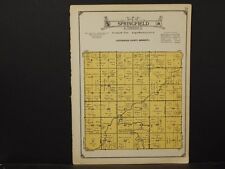 Minnesota, Cottonwood County Map, 1926 Township of Springfield Y1#54
-
$32.78 CAD
 Minnesota Morrison County Map Little Falls Township c.1920 U2#05
-
$21.83 CAD
 Minnesota Cottonwood County Map Selma Township 1926 Y7#72
-
$21.83 CAD
 Minnesota Blue Earth County Map Rapidan Township 1929 W7#52
-
$32.78 CAD
 Minnesota Morrison County Map Buckman Royalton Vawter Townships c.1920 U1#78
-
$32.78 CAD
 Minnesota Morrison County Map Leigh Townships c.1920 U1#98
-
$21.83 CAD
 Minnesota Morrison County Map Motley Upsala Townships c.1920 U1#79
-
$32.78 CAD
 Minnesota Morrison County Map Platte Townships c.1920 U1#95
-
$32.78 CAD
 Minnesota Morrison County Map Swanville Townships c.1920 U1#92
-
$21.83 CAD
 Minnesota Sibley County Map Grafton Township 1926 Y7#57
-
$21.83 CAD
 Minnesota Sibley County Map New Auburn Township 1926 Y7#58
-
$32.78 CAD
 Minnesota Le Sueur County Map Tyrone or Waterville Township 1928 Dbl Side L10#76
-
$32.78 CAD
 Minnesota Morrison County Map Culdrum Townships c.1920 U1#91
-
$32.78 CAD
 Minnesota Blue Earth County Map 1929 Double Page W7#63
-
$21.83 CAD
 Minnesota Murray County Map Des Moines River Township 1926 W5#96
-
$21.83 CAD
 Minnesota Murray County Map Dovray Township 1926 W5#98
-
$32.78 CAD
 Minnesota Morrison County Map Elmdale Townships c.1920 U1#94
-
$32.78 CAD
 Minnesota Morrison County Map Morrill Township c.1920 U2#11
-
$21.83 CAD
 Minnesota Murray County Map Murray Township 1926 W6#01
-
$32.78 CAD
 Minnesota Morrison County Map Mount Morris Township c.1920 U2#09
-
$32.78 CAD
 Minnesota Morrison County Map Richardson Township c.1920 U2#03
-
$32.78 CAD
 Minnesota Morrison County Map Hillman Township c.1920 U2#08
-
$43.72 CAD
 Minnesota Le Sueur County Map Waterville 1928 Dbl Side/Page L10#75
-
$32.78 CAD
 Minnesota Le Sueur County Map Elysian Township 1928 Dbl Side L10#83
-
$32.78 CAD
 Minnesota Morrison County Map Rosing Motley Townships c.1920 U1#82
-
$136.73 CAD
 1923 PITTSBURGH PA GREENFIELD CALVARY CEMETERY MINNESOTA ST-MURRAY ST ATLAS MAP
-
$32.78 CAD
 Minnesota, Cottonwood County Map, 1926 Y1#39
-
$32.78 CAD
 Minnesota Le Sueur County Map Elysian Township 1928 Dbl Side L10#83
-
$54.65 CAD
 1927 Minneapolis & St. Paul, MN Twin Cities Map, New World Atlas and Gazetteer
-
$21.83 CAD
 Minnesota Blue Earth County Map Mankato South Bend Township Dbl Pg 1929 W7#42
-
$21.83 CAD
 Minnesota Blue Earth County Map Butternut Valley Township 1929 W7#59
-
$21.83 CAD
 Minnesota Cottonwood County Map Rose Hill Township 1926 Y7#68
-
$21.83 CAD
 Minnesota Sibley County Map 1926 Y7#47
-
$21.83 CAD
 Minnesota Sibley County Map Kelso Township 1926 Y7#50
-
$21.83 CAD
 Minnesota Murray County Map Fenton Township 1926 W5#90
-
$32.78 CAD
 Minnesota Murray County Map 1926 W5#86
-
$21.83 CAD
 Minnesota Sibley County Map Washington Township 1926 Y7#59
-
$21.83 CAD
 Minnesota Murray County Map Belfast Township 1926 W5#87
-
$21.83 CAD
 Minnesota Cottonwood County Map Great Bend Township 1926 Y7#64
-
$21.83 CAD
 Minnesota Sibley County Map Moltke Township 1926 Y7#56
-
$21.83 CAD
 Minnesota Murray County Map Cameron Township 1926 W6#02
-
$21.83 CAD
 Minnesota Murray County Map Lowville Township 1926 W6#03
-
$21.83 CAD
 Minnesota Sibley County Map Arlington Township 1926 Y7#52
-
$21.83 CAD
 Minnesota Sibley County Map Transit Township 1926 Y7#54
-
$32.78 CAD
 Minnesota Morrison County Map Two Rivers North Prairie Townships c.1920 U1#97
-
$136.73 CAD
 1923 PITTSBURGH PA GREENFIELD BIGELOW ST TO MINNESOTA ST LOGAN SCHOOL ATLAS MAP
-
$21.83 CAD
 Minnesota Blue Earth County Map McPherson Township 1929 W7#57
-
$21.83 CAD
 Minnesota Cottonwood County Map Southbrook Township 1926 Y7#67
-
$32.78 CAD
 Minnesota Morrison County Map Darling & Randall Townships c.1920 U1#83
-
$32.78 CAD
 Minnesota Morrison County Map Pike Creek Townships c.1920 U1#90
-
$32.78 CAD
 Minnesota Morrison County Map Bellevue Township c.1920 U2#13
-
$21.83 CAD
 Minnesota Murray County Map Lake Holly Township 1926 W6#07
-
$32.78 CAD
 Minnesota Morrison County Map Pulaski Township c.1920 U2#04
-
$32.78 CAD
 Minnesota Morrison County Map Agram Township c.1920 U2#06
-
$21.83 CAD
 Minnesota Murray County Map Lake Sarah Township 1926 W6#05
-
$21.83 CAD
 Minnesota Cottonwood County Map Lakeside Township 1926 Y7#65
-
$32.78 CAD
 Minnesota Morrison County Map Green Prairie Townships c.1920 U1#89
-
$32.78 CAD
 Minnesota Morrison County Map Swanriver Townships c.1920 U1#93
-
$32.78 CAD
 Minnesota Morrison County Map Clough Townships c.1920 U1#85
-
$32.78 CAD
 Minnesota Morrison County Map Parker Townships c.1920 U1#84
-
$21.83 CAD
 Minnesota Murray County Map Iona Township 1926 W5#91
-
$21.83 CAD
 Minnesota Blue Earth County Map Beauford Township 1929 W7#49
-
$21.83 CAD
 Minnesota Blue Earth County Map Danville Township 1929 W7#47
-
$21.83 CAD
 Minnesota Blue Earth County Map Medo Township 1929 W7#48
-
$21.83 CAD
 Minnesota Blue Earth County Map Lincoln Township 1929 W7#54
-
$36.87 CAD
 1927 Minnesota Map, New World Atlas and Gazetteer
-
$21.83 CAD
 Minnesota Blue Earth County Map Lyra Township 1929 W7#50


