 Antiques (CA)
-
$44.46 CAD

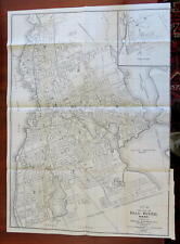 Fall River Massachusetts 1923 Sampson & Murdock detailed large folding city plan
-
$136.79 CAD
 Road Map of the North Shore &part of MiddlesexCo Mass c1920s Walker Lith & PubCo
-
$38.30 CAD
 Map South End Boston Fort Hill 1925 Historical Massachusetts DWX3A
-
$38.30 CAD
 Map Shawmut Trimountain c1630 Boston 1925 Historical Massachusetts DWX3A
-
$68.40 CAD
 North Meadows Cemetery detailed Map ca 1922 Greenfield MA
-
$19.08 CAD
 1926 Boston Massachusetts Historic Vintage Style Illustrated Wall Map - 18x24
-
$9.58 CAD
 Map Massachusetts Small 7" X 5" 1928
-
$61.56 CAD
 Ashfield Colonial Lotting Plan Map Massachusetts ca 1920 tracing eb-251
-
$38.30 CAD
 Map The Neck Boston Charles River 1925 Historical Massachusetts DWX3A
-
$6.84 CAD
 antique folding map 1920s Rand McNally Massachusetts Connecticut Rhode Island
-
$35.57 CAD
 1921 Folding Map BOSTON Sampson & Murdock Publishers 36" x 32"
-
$54.72 CAD
 Millers Falls 1923 Linen Map - eb 253
-
$21.89 CAD
 1920 Railroad Map - Canada New England New York Boston Toronto Quebec RR Freight
-
$38.30 CAD
 Map West End Boston Copper Works 1925 Historical Massachusetts DWX3A
-
$136.79 CAD
 Road Map of the South Shore & part of Norfolk Co Massachusetts c1920s
-
$135.43 CAD
 3' x 4' 1924 Soil Survey Map Middlesex County MA Boston Gorgeous Color Very Rare
-
$37.14 CAD
 **1921 - 20" x 14" Map ~ BOSTON - CHARLESTON - CAMBRIDGE ~ Free S&H
-
$108.34 CAD
 1926 Clason Auto Road Map & Distance Chart United States Transcontinental Trails
-
$27.35 CAD
 1843 USGS Map of Groton Mass Reprinted in 1923
-
$23.19 CAD
 1920s “Cape Ann and the North Shore” Vintage Style Massachusetts Map - 20x24
-
$19.08 CAD
Cape Ann Massachusetts 1927 Vintage Style Illustrated Map - 16x20
-
$27.99 CAD
 Vintage NEW ENGLAND Auto Trails Map Highway Massachusetts Rhode Island Road
-
$38.30 CAD
 Map North End Boston 1925 Mill Pond Wharf Historical Massachusetts DWX3A
-
$34.20 CAD
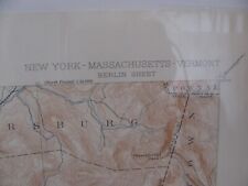 Original Geological Survey Map, NY / MASS / VERMONT/ Berlin Sheet, 1927
-
$31.35 CAD
 Southern NEW ENGLAND Highway Map Road Vintage Original Antique Massachusetts
-
$38.30 CAD
 Map Town Of Boston c1645 Book Possessions 1925 Historical Massachusetts DWX3A
-
$752.37 CAD
 Carolyn H. Galbraith HAND DRAWN MAP SMITH COLLEGE, NORTHAMPTON MASS 1928 18x18
-
$752.36 CAD
 1926 Cape Cod Pictorial Map Elisabeth Leonard Fecit Original Framed VERY RARE!
-
$61.56 CAD
 1923 Map GREENFIELD QUAD MA Geological Survey 16x20" (folded) Bald Mountain etc
-
$32.76 CAD
 1926 Nantucket Island Massachusetts Historic Vintage Style Wall Map - 24x30
-
$49.25 CAD
 1927 Map FITCHBURG QUAD MA Geological Survey 16x20" (folded) HAND MARKED
-
$38.30 CAD
 Map Boston Government Business Center 1925 Historical Massachusetts DWX3A
-
$30.23 CAD
 Antique 1921 Boston Massachusetts City Street Map from Atlas Business Inset
-
$540.34 CAD
 Vintage 1927 FRANKLIN MASSACHUSETTS Sanborn Insurance MAPS Atlas - DEAN College
-
$41.04 CAD
 1930 Car Auto Roads Between Canada & USA Atlantic Sheet Map Large Color
-
$9.56 CAD
 Antique 1923 Post World War I Atlas City Map Boston Cambridge MA, Massachusetts
-
$38.29 CAD
 1921 Johnston Map United States Massachusetts Vermont Maine New York Jersey USA
-
$17.51 CAD
 MA RI 1920 MASSACHUSETTS Map BOSTON HARBOR or RHODE ISLAND Map PROVIDENCE
-
$13.67 CAD
 c 1925 Hammond County Map - Massachusetts & Rhode Island - Boston Providence
-
$12.31 CAD
 1924 City Map of Boston Mass. 101/4 by 141/2 inches. Great condition
-
$478.78 CAD
 Shawmut: Boston / 1928 Illustrated Pictorial Map of Boston Massachusetts 1st ed
-
$103.79 CAD
 1925 Nirenstein Map Lowell Massachusetts 100% Business Old City Street Locations
-
$136.79 CAD
 u.s. Geological Survey map Gloucester Massachusetts 1926, 20x16.5
-
$68.33 CAD
 1921 EVERETT MASSACHUSETTS MIDDLESEX COUNTY, INDEX PAGE COPY PLAT ATLAS MAP
-
$306.42 CAD
 Sanborn Fire Insurance Map Holyoke, Massachusetts 1915
-
$43.71 CAD
 1921 Massachusetts Map with Highways, Boston Inset, Cram's Good Roads Atlas
-
$102.53 CAD
 ORIGINAL 1924 LYNN MASSACHUSETTS LYNN WOOD SLUICE & WALDEN POND ATLAS MAP
-
$102.53 CAD
 George Walker Colored Pocket Map Massachusetts 1893
-
$109.37 CAD
 ORIGINAL 1924 WEST ROXBURY BOSTON MASSACHUSETTS INDEX PAGE GW BROMLEY ATLAS MAP
-
$103.79 CAD
 1925 Nirenstein Map Lawrence Massachusetts 100% Business City Street Locations
-
$68.33 CAD
1924 WEST ROXBURY BOSTON, MASSACHUSETTS INDEX PAGE G.W. BROMLEY PLAT ATLAS MAP
-
$103.79 CAD
 1925 Nirenstein Map Fall River Massachusetts 100% Business City Street Locations
-
$103.79 CAD
 Nirenstein 1925 Worcester, Massachusetts Old City Street Map 100% Business
-
$102.53 CAD
 ORIGINAL 1924 CITY OF LYNN MASSACHUSETTS RICHARDS MAP CO TITLE PAGE ATLAS MAP
-
$205.12 CAD
 ORIGINAL 1924 LYNN MASSACHUSETTS CITY HALL HIGH ROCK PARK ENGLISH H.S. ATLAS MAP
-
$102.53 CAD
 ORIGINAL 1924 LYNN MASSACHUSETTS GENERAL ELECTRIC RIVERWORKS ATLAS MAP
-
$109.37 CAD
 ORIGINAL 1924 CITY OF LYNN, MASSACHUSETTS RICHARDS MAP CO INDEX PAGE ATLAS MAP
-
$205.12 CAD
 ORIGINAL 1924 LYNN MASSACHUSETTS MEADOW-KEARNEY PARK BAYVIEW-EUTAW AVE ATLAS MAP
-
$395.34 CAD
 Shawmut: Boston / 1928 Illustrated Pictorial Map of Boston Massachusetts 1st ed
-
$205.12 CAD
 1924 EAST LYNN MASSACHUSETTS GREEN ST-EASTERN AVE & NAHANT BAY-HOWARD ATLAS MAP
-
$54.65 CAD
 1927 Boston, MA Map, New World Atlas and Gazetteer
-
$109.37 CAD
 1924 LYNN MASSACHUSETTS BIRCH POND-HAYES ST & FAIRMONT AV-MYRTLE ST ATLAS MAP
-
$109.37 CAD
 1924 LYNN MASSACHUSETTS MYRTLE ST-HOLDER'S POND & ONTARIO ST-MASON ST ATLAS MAP
-
$82.01 CAD
ORIGINAL 1921 EVERETT MASSACHUSETTS MIDDLESEX COUNTY, INDEX PAGE, PLAT ATLAS MAP
-
$410.37 CAD
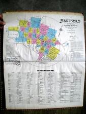 Original 1929 SANBORN Fire Insurance Plat Maps Atlas of MARLBORO MA Frye Boots
-
$205.12 CAD
 1924 LYNN MASSACHUSETTS ELVIR ST-COLUMBIA AV & CHATHAM ST-HILLSIDE AV ATLAS MAP
-
$205.12 CAD
 1924 LYNN MASSACHUSETTS FLEX POND TO GLEN ROCK AV & CHESTNUT-GLENMERE ATLAS MAP


