 Antiques (CA)
Africa Maps
Asia Maps
Australia/Oceania Maps
Celestial Maps
Central America/Caribbean Maps
Curiosities Maps
Digital Maps
Europe Maps
Map & Globe Mixed Lots
Map & Globe Reproductions
North America Maps
South America Maps
World & Celestial Globes
World Maps

-
$349.52 CAD

 A Concise Gazetteer of the World for the Use of Schools by Earnshaw, 1824 7 Maps
-
$188.46 CAD
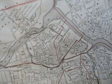
 New York City 1869 detailed plan map Wards Districts Political Legal Schools
-
$102.80 CAD
 Antique Hand Colored MAP - UNITED STATES / Common School Geography 1873
-
$61.68 CAD
 Antique Hand Colored MAP TEXAS, CALIFORNIA & OREGON Common School Geography 1873
-
$13.69 CAD
 1885 Cortambert Map - France Meteorology Climate Geology Minerals Ores - Paris
-
$41.05 CAD
 1879 Original Engraved color MAP OF WESTERN STATES AND TERRITORIES new 11x14 mat
-
$53.11 CAD
 WORLD MAP 1844 (1849) Robinson, Olney School Geography WORLD MAP 11x18" G-VG
-
$34.25 CAD
 USSR WALL MAP /Political WORLD Division 1876/ Old POSTER Vintage Soviet 1.7m=69"
-
$198.74 CAD
 1890s Political Map of Africa Colonial Era Caxton School Pull Down Wall Large
-
$34.20 CAD
 1877 Kingman Bros Miami Co Indiana Map Page Denver College/Normal School portIN5
-
$37.69 CAD
 Lynn Massachusetts Railroad Parks Schools 1870's detailed city plan map
-
$47.90 CAD
 Antique Map of Australia, Oceanica Mitchell's School Atlas Print 1846 9x11.5"
-
$3358.09 CAD
 Antique School Girl Map On Silk Of United States Mary Russell 1808
-
$51.40 CAD
 Lowell Massachusetts City Plan Gasworks Fairground Farm Schools 1891 Walker map
-
$61.68 CAD
 Antique Hand Colored MAP/BRITISH PROV. NORTH AMER. Common School Geography 1873
-
$798.40 CAD
 1865 J.H. Colton's American School Quarto Geography W/ 100+ STEEL PLATE MAPS
-
$53.46 CAD
 Burgess & Cain 1853 Map #9 Wisconsin and Michigan
-
$100.04 CAD
 Rare original 1869 Map of the City Of New York-politics, school districts& wards
-
$45.16 CAD
 Antique Map of Europe, Mitchell's School Atlas Hand Colored Print 1846 9x11.5"
-
$821.02 CAD
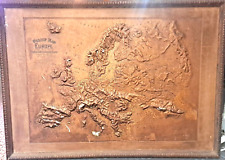 Large United States Relief Map of Europe Central School Supply House 1892
-
$21.92 CAD
 1852 Eduard Beer Miniature Map Bohemia Czechia Prague Slovakia Poland Germany EU
-
$34.48 CAD
USSR WALL MAP /Political WORLD Division 1876/ Old POSTER Vintage Soviet 1.7m=69"
-
$21.92 CAD
 1852 Eduard Beer Miniature Map Netherlands Holland Belgium Amsterdam Brussels EU
-
$13.69 CAD
 1852 Eduard Beer Miniature Map NW Germany Hanover Westphalia Oldenburg Bremen
-
$16.43 CAD
 1852 Eduard Beer Miniature Map Greece Turkey Albania Macedonia Crete Athens EU
-
$21.92 CAD
 1852 Eduard Beer Miniature Map Germany Prussia Poland Krakow Warsaw Danzig EU
-
$16.43 CAD
 1852 Eduard Beer Miniature Map Germany Bavaria Baden Wurtemburg Munich Frankfurt
-
$21.92 CAD
 1852 Eduard Beer Miniature Map Austria Vienna Italy Tyrol Illyieren Germany Alps
-
$61.68 CAD
 Antique Hand Colored MAP OF NORTH AMERICA Common School Geography 1873
-
$61.68 CAD
 Antique Hand Colored MAP OF US RAILROAD LINES Common School Geography 1873
-
$41.12 CAD
 Antique Hand Colored MAP - MEXICO & CENTRAL AMER / Common School Geography 1873
-
$61.68 CAD
 Antique Hand Colored MAP - MASS. RHODE ISL & CONN / Common School Geography 1873
-
$21.92 CAD
 1852 Eduard Beer Miniature Map France Paris Marseille Lyon Tours Amiens Rouen FR
-
$16.43 CAD
 1852 Eduard Beer Miniature Map NE Germany Brandenburg Berlin Mecklenburg Dresden
-
$21.92 CAD
 1852 Eduard Beer Miniature Map Russia Ukraine Belarus Latvia Estonia Finland EU
-
$21.92 CAD
 1852 Eduard Beer Miniature Map Hungary Budapest Croatia Dalmatia Slavonia Balkan
-
$13.69 CAD
 1885 Cortambert Map - France Universities Church Judicial Military Corps - Paris
-
$21.92 CAD
 1852 Eduard Beer Miniature Map Switzerland Zurich Geneva Lucerne Berne Swiss Alp
-
$61.68 CAD
 Antique Hand Colored MAP OF 9 THE WESTERN STATES/US Common School Geography 1873
-
$61.68 CAD
 Antique Hand Colored MAP - SOUTHERN STATES OF US / Common School Geography 1873
-
$21.92 CAD
 1852 Eduard Beer Miniature Map Greece Turkey Europe Crete Athens Constantinople
-
$21.92 CAD
 1852 Eduard Beer Miniature Map Sweden Norway Finland Stockholm Christiania EU
-
$26.04 CAD
 ANTI1QUE 1863 ORIG MAP # 4 NORTH AMERICA & EAST & WEST HEMISPHERES N & S-
-
$61.03 CAD
Antique Hand Colored MAP/BRITISH PROV. NORTH AMER. Common School Geography 1873
-
$342.66 CAD
 Antique 1847 Lot of 3 British Student Drawn School Maps-England West Indies
-
$109.65 CAD
 c 1821 Morse Map World in Hemispheres North America Europe Asia Australia Africa
-
$37.28 CAD
 1852 Map Southern Western United States Florida South Carolina Louisiana Alabama
-
$47.90 CAD
 Antique Map of Asia Hand Colored Mitchell's School Atlas Map 1846 9x11.5"
-
$11.65 CAD
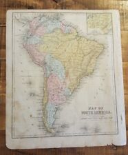
 1896 Harper’s School Geography Political Map of SOUTH AMERICA Color 9x12” FL1
-
$108.21 CAD
 Antique 1870 BRITISH AMERICA Map Paper on Linen National School Map Canada
-
$13.69 CAD
 1885 Cortambert Map - France in Departments - Paris Lille Lyon Marseilles Seine
-
$68.53 CAD
 1863 ME-NH-VT ORIG PRE-CIVIL WAR MAP PAGE FROM MITCHELL'S SCHOOL GEOGRAPHY
-
$61.03 CAD
Antique Hand Colored MAP OF NORTH AMERICA Common School Geography 1873
-
$40.69 CAD
Antique Hand Colored MAP - MEXICO & CENTRAL AMER / Common School Geography 1873
-
$40.69 CAD
 Antique Hand Colored MAP - GREAT BRITAIN & IRELAND/Common School Geography 1873
-
$61.68 CAD
 1858 TINTED MAP SOUTHERN STATES w BATTLE FLAGS, MITCHELL SCHOOL FAMILY GEOGRAPHY
-
$38.36 CAD
 c 1820 Morse Map Europe Spain France Austria Germany Italy Britain Sweden Russia
-
$10.91 CAD
 Ohio Hancock County Map 1875 Church Jail Court House School House Findlay J2#77
-
$61.03 CAD
Antique Hand Colored MAP OF 9 THE WESTERN STATES/US Common School Geography 1873
-
$68.52 CAD
 Original 1872 Map LYMAN York County Maine Shakers Schools Railroad Mills History
-
$40.69 CAD
 Antique Hand Colored MAP - SOUTH AMERICA - Common School Geography 1873
-
$89.09 CAD
 MISC. LOT 6 ORIGINAL ANTIQUE MAPS OF EUROPE, ASIA & EGYPT
-
$68.53 CAD
 1863 MAP MEXICO, CENTRAL AMERICA & WEST INDIES FROM MITCHELL'S SCHOOL GEOGRAPHY-
-
$61.03 CAD
Antique Hand Colored MAP - MASS. RHODE ISL & CONN / Common School Geography 1873
-
$68.46 CAD
 1884, A.H. MUELLER READING BERKS COUNTY, PA, ELM ST. N.8TH TO N11 ST SCHOOL MAP
-
$61.03 CAD
 Antique Hand Colored MAP OF MAINE, N.H. & VERMONT Common School Geography 1873
-
$15419.81 CAD
 RARE NYC SCHOOL HANGING MAP 1860 New York And Its Environs SD Tilnden
-
$54.81 CAD
 ANTIQUE 1874 DURHAM CLINTON MORGAN SCHOOL MIDDLESEX COUNTY CONNECTICUT MAP RARE
-
$479.84 CAD
 School Wall Map Austria 1815-1923 History 78 11/16x64 3/16in Vintage~1960
-
$27.41 CAD
 Antique Map of Africa, Liberia, Egypt Sahara Ethiopia 1844 Olneys Geography
-
$68.46 CAD
 1891 BUFFALO RIVER TO HAMBURG CANAL NEW YORK P.S. 4 & 34 ST BRIDGET'S SCHOOL MAP
-
$130.21 CAD
 NJ50 Original 1878 Antique Map Long Branch Graded School, Long Branch NJ
-
$61.68 CAD
Antique Hand Colored MAP OF MAINE, N.H. & VERMONT Common School Geography 1873
-
$102.79 CAD
 Antique Map US 1855 Geography School Western States Pennsylvania, NY, NJ, Delawa
-
$41.12 CAD
Antique Hand Colored MAP - SOUTH AMERICA - Common School Geography 1873
-
$10.91 CAD
 Illinois Adams County Map Public School Building William Barclay 1872 K18#36
-
$214.00 CAD
 1865 VICTORIAN MAP THE LANDMARKS OF LONDON railway stations museums schools etc
-
$342.66 CAD
 Orig. 1866 Colton & Fitch School Geography Engravings & 40 Hand Colored Maps
-
$13.71 CAD
 1868 National Geographical Series No 2 James Monteith ACE
-
$21.88 CAD
 Pennsylvania Beaver County Map Soldier's Orphan School Engravings 1876 Q4#77
-
$34.27 CAD
 1887 HARPER'S SCHOOL GEOGRAPHY - Good Copy - 130+ pages - MANY MAPS + MORE
-
$678.47 CAD
 1876 Disturnell City Map or Plan of New York City Illustrating School Districts
-
$34.27 CAD
 1856 Map: Oceania Designed to Accompany Cornell's High School Geography Appleton
-
$10.91 CAD
 Illinois Adams County Map Public School Engravings 1872 K18#90
-
$10.91 CAD
 Illinois Adams County Map Maplewood School Casco Mills Engravings 1872 K18#82
-
$10.91 CAD
 Indiana Howard County Map Russiaville Public School Engravings 1877 Y13#19
-
$10.91 CAD
 Vermont Rutland County Map Rutland High School Engravings 1869 W7#77
-
$21.88 CAD
 Vermont, Windsor Co Map, Union School Building Engravings, 1869 Y3#03
-
$10.91 CAD
 Ohio Portage County Map Union Schools Bank Block Engravings 1874 J17#43
-
$213.80 CAD
 Antique Map 14-336 Victoria - showing State Schools c.1886
-
$129.17 CAD
 Antique Map 14-335 Victoria showing State Schools c.1893
-
$274.12 CAD
 RARE BIG SCHOOL POSTER USSR 1984 MAP PATRIOTIC WAR 1812 NAPOLEON AGAINST RUSSIA
-
$21.88 CAD
 Connecticut Map 1893 Meriden St Roses Church Parochial Res Covent & School L5#75
-
$176.81 CAD
 1872 GEOGRAPHY ATLAS,D.M.WARREN SCHOOL,33 COLOR MAPS,65 ILLUSTRATIONS
-
$11.65 CAD
 1896 Harper’s School Geography Physical Map of SOUTH AMERICA Color 9x12” FL1
-
$61.03 CAD
Antique Hand Colored MAP OF US RAILROAD LINES Common School Geography 1873
-
$61.03 CAD
Antique Hand Colored MAP TEXAS, CALIFORNIA & OREGON Common School Geography 1873
-
$61.03 CAD
Antique Hand Colored MAP - SOUTHERN STATES OF US / Common School Geography 1873
-
$101.72 CAD
Antique Hand Colored MAP - UNITED STATES / Common School Geography 1873


