 Antiques (CA)
Africa Maps
Asia Maps
Australia/Oceania Maps
Celestial Maps
Central America/Caribbean Maps
Curiosities Maps
Digital Maps
Europe Maps
Map & Globe Mixed Lots
Map & Globe Reproductions
North America Maps
South America Maps
World & Celestial Globes
World Maps

-
$273.59 CAD

 1867 Kansas Colorado Montana & Dacota Hand Colored Map 13 x 15 Mitchell Antique
-
$109.42 CAD
 1879 Map Maine United States New England Victorian Geography 1st Edition DWAA9
-
$54.70 CAD
 Map Of Original 13 Colonies 1871 Victorian Lithograph History Swinton DWAA12
-
$205.19 CAD
 Original Circa 1850 Map Of Oregon Boundary Lithograph By A. Hoen & Co.
-
$38.30 CAD
 1899 Map Balkan Peninsula ORIGINAL Constantinople Bulgaria Serbia Montenegro
-
$46.51 CAD
 1897 Map ITALY ORIGINAL Rome Venice Sicily STEAMSHIPS RAILWAYS Sardinia Naples
-
$94.39 CAD
 1878 California Mitchell antique map 22.9" x 15.1" - San Francisco inset
-
$61.56 CAD
 1862 Johnson's Missouri and Kansas Map Johnson & Ward Antique
-
$53.35 CAD
 1878 Maine Mitchell antique map 15.1" x 12.1" - nice color
-
$80.71 CAD
 1862 Johnson Minnesota & Dakota antique map 17.2" x 14" nice color
-
$102.60 CAD
 1849 Lithograph of 1st Printed Chart of Coast of New England & New Netherlands
-
$239.39 CAD
 1845 antique map of Africa by A.K. Johnston ~ 25.8" x 21.2" Huge Pastel color
-
$170.99 CAD
 1883 General Sherman Route Map Fort Ellis Montana to Fort Hope British Columbia
-
$129.96 CAD
 1886 Malte-Brun Ancient Asia Map
-
$109.42 CAD
 1879 Map Asia Desert Arctic Peninsula Belt Victorian Geography 1st Edition DWAA9
-
$109.42 CAD
 1879 North Central States Group US Victorian Atlas Geography 1st Edition DWAA9
-
$20.52 CAD
 Australia & New Zealand - Original 1874 Hydro-Orographic Map by Meyers.
-
$135.43 CAD
 1878 Colorado Montana Dakota & Wyoming Mitchell antique map 22.9" x 15.1"
-
$102.58 CAD
 1885 ANTIQUE MAP 21.75" Eskimo Tribes NORTH EAST AMERICA CANADA Nunavut Dr. Boas
-
$143.63 CAD
 1860 Wisconsin & Michigan Mitchell antique map 15.3" x 12.7" rare 1st edition
-
$27.36 CAD
 Original 1884 Physical & Economic Map of The British Isles by Drioux & Leroy
-
$512.98 CAD
 1862 Johnson California Southwest Territory antique map 26.1" x 18.7" nice color
-
$649.78 CAD
 1845 World Hemispheres map by A.K. Johnston ~ 25.8" x 21.2" Antique Pastel Color
-
$31.45 CAD
 1898 ORIGINAL MAP WORLD AMERICA ASIA AUSTRALIA EUROPE AFRICA sea currents OCEANS
-
$239.39 CAD
 1875 Map Yellowstone Montana Captain William Ludlow US Army Corps Engineers
-
$4.10 CAD
 1894 Map of SIBERIA & AMUR TERRITORY. Original antique print China Russia
-
$20.52 CAD
 1897 BAEDEKER MAP - Germany HAMBURG City Plan + Railroads
-
$61.56 CAD
 1878 United States map 22.8" x 15.1" nice color - Island of New Foundland inset
-
$109.42 CAD
 1879 Map West Central States Group Victorian Atlas Geography 1st Edition DWAA9
-
$109.42 CAD
 1879 Map Australia Colonies And Oceania Victorian Geography 1st Edition DWAA9
-
$109.42 CAD
 1879 Map New England USA Victorian Atlas Harpers Geography 1st Edition DWAA9
-
$109.42 CAD
 1879 Map Europe Spain France Italy England Victorian Geography 1st Edition DWAA9
-
$13.67 CAD
 1898 Century Map Switzerland Geneva Zurich Lucerne Bern Basel Lake of Constance
-
$28.77 CAD
 1897 BAEDEKER MAP - WALES between Bangor & Tremadog
-
$273.59 CAD
 1845 Palestine map by A.K. Johnston ~ 25.8" x 21.2" Antique Pastel Color Huge
-
$4.10 CAD
 1894 Map of Siberia Altai & Baikal See Original antique print China Russia
-
$16.42 CAD
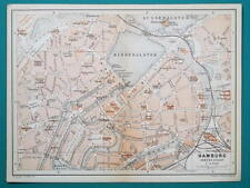
 1897 BAEDEKER MAP - Germany Hamburg & Environs
-
$203.82 CAD
 1878 Texas antique map 22.8" x 15.1" nice color - Galveston Indian Territory NM
-
$82.06 CAD
 Map Territorial Growth Of United States 1871 Victorian Lithograph History DWAA12
-
$109.42 CAD
 1879 Map West Pacific NW & Southwest Group Victorian Geography 1st Edition DWAA9
-
$61.56 CAD
 1878 Georgia Alabama Mitchell antique map 22.7" x 15.1" Atlanta Savannah insets
-
$53.35 CAD
 1878 Western Hemisphere Mitchell antique map 15.1" x 12.1" - nice color
-
$19.84 CAD
 Antique Map: Geneva, Lausanne, Switzerland, Lac Leman - 1898
-
$25.98 CAD
 Original 1899 Map NORTH POLE Arctic Explorers Nansen Johansen Franklin McClure
-
$683.97 CAD
 1845 North America map by A.K. Johnston 25.8" x 21.2" Antique Republic of Texas
-
$47.88 CAD
 1862 Johnson Iowa & Nebraska antique map 17.6" x 14.2" nice color
-
$177.82 CAD
 1884 ANTIQUE MAP Indian Removal CHEROKEE NATION 32" Arkansas Kansas Missouri
-
$53.35 CAD
 1878 Oregon Washington MT ID Mitchell antique map 15.1" x 12.3" - nice color
-
$341.99 CAD
 1849 Traveler's Map of West Prussia on Cloth, Handtke, Druck & Verlag, Flemming
-
$102.60 CAD
 1856 Wisconsin & MN Survey Antique Map Lithograph - Ackerman NY ~ 21.5" x 18.7"
-
$61.56 CAD
 1862 Johnson Iowa & Nebraska antique map 17.6" x 14.2" nice color
-
$35.18 CAD
 1897 BAEDEKER MAP - Germany HAMBURG & ALTONA Good for Genealogy
-
$129.96 CAD
 1862 Johnson Dakota Nebraska Kansas Colorado antique map 17.4" x14.2" nice color
-
$10.00 CAD
 Antique map. EUROPE. PHYSICAL MAP OF EUROPE. Circa 1885
-
$47.88 CAD
 1863 China by Johnson Ward antique map 17.4" x 13.8" Amoy & Canton insets
-
$102.60 CAD
 1862 Johnson Virginia PA DE MD antique map 26.6" x 18.1" nice color - Richmond
-
$239.39 CAD
 1845 Ireland map by A.K. Johnston ~ 25.8" x 21.2" Antique Pastel Color Huge
-
$121.75 CAD
 1878 Boston Mitchell antique map / plan 23" x 15.1" - nice color - harbor inset
-
$170.99 CAD
 1877 F. V. Hayden Parts of Western Wyoming and Southeastern Idaho Map
-
$376.19 CAD
 1862 Johnson Texas antique map 25.6" x 18.6" nice color - Galveston, Sabine Lake
-
$15.00 CAD
 Antique map. THE WORLD PHYSICAL MAP. Circa 1885
-
$27.36 CAD
 1899 Antique FOLDING MAP: CONTINENT OF AFRICA ~ J. MARTIN MILLER 22 X 17 ~ CLEAN
-
$451.29 CAD
 ANTIQUE 1857 J&F TALLIS MAP OF CANADA MOST DECORATED PRE-CONFEDERATION EXAMPLE
-
$61.56 CAD
 1878 Kentucky & Tennessee Mitchell antique map 15.1" x 12" - nice color
-
$20.52 CAD
 1887 MAP BAEDEKER - Germany Ulm Town Plan 4 x 6" (10 x 15,5 cm)
-
$17.10 CAD
 1887 MAP PLAN BAEDEKER - Germany Bamberg & Kissingen 4 x 6" (10 x 15,5 cm)
-
$27.35 CAD
 1873 Guyot Physical Map Nature Animals Trees Latitudes Jungle to Arctic Antique
-
$41.04 CAD
 1864 Australia by Johnson Ward antique map 18.1" x 14.25" - nice color
-
$348.83 CAD
 1860 Washington & Oregon Mitchell antique map 15.4" x 12.6" rare 1st edition
-
$51.91 CAD
 Antique 1864 Map ASIA China Persia Russia Turkey Tibet~Handcolor~Johnson's Atlas
-
$16.42 CAD
 1887 MAP BAEDEKER - AUSTRIA Vienna & Environs + Plan of Laxenburg Castle & Park
-
$75.24 CAD
 1878 North & South Carolina Mitchell antique map 15.1" x 12.3" - nice color
-
$20.52 CAD
 1897 BAEDEKER MAP - Germany CHEMNITZ Zwickau Jachymov & Environs + Railroads
-
$258.54 CAD
 1860 Minnesota & Dacotah Mitchell antique map 15.5" x 12.7" rare 1st edition
-
$75.24 CAD
 1862 Johnson Kentucky & Tennessee antique map 24.7" x 17.9" nice color
-
$16.42 CAD
 1897 BAEDEKER MAP - Germany Dresden Tharandt & Environs
-
$61.56 CAD
 1862 Johnson's New York Map Johnson & Ward Illustrated Family Atlas Antique
-
$239.39 CAD
 1845 Greece map by A.K. Johnston ~ 25.8" x 21.2" Antique Pastel Color Huge
-
$80.71 CAD
 1878 New York Mitchell antique map 23" x 15.1" nice color & city insets
-
$67.03 CAD
 1862 Johnson state of New Jersey antique map 16.6" x 14" nice color
-
$203.82 CAD
 Antique Print Solar System Theory of the Seasons Rand McNally illustration 1890s
-
$19.15 CAD
 1887 MAP BAEDEKER - GERMANY Regensburg & Augsburg 4 x 6" (10 x 15,5 cm)
-
$88.92 CAD
 1856 Louisiana Antique Survey Map - Lithograph - Duval - 18.3" x 17" - Congress
-
$88.92 CAD
 1862 Johnson New York with many insets antique map 26.1" x 17.8" nice color
-
$19.84 CAD
 1887 MAP BAEDEKER - GERMANY Plan of Stuttgart City & Environs Umgebung
-
$53.35 CAD
 1878 Virginia & West, MD DE & NJ Mitchell antique map 15.1" x 12" - nice color
-
$273.59 CAD
 1845 Europe map by A.K. Johnston ~ 25.8" x 21.2" Antique Pastel Color Huge
-
$239.39 CAD
 1845 North Italy map by A.K. Johnston ~ 25.8" x 21.2" Antique Pastel Color Huge
-
$16.42 CAD
 1897 BAEDEKER MAP - Germany Kiel Denmark Sondenburg & Environs
-
$30.09 CAD
 1897 BAEDEKER MAP - Germany Thuringen Forest Erfurt Weimar Gotha Zella Suhl
-
$239.39 CAD
 1845 Austria map by A.K. Johnston ~ 25.8" x 21.2" Antique Pastel Color Huge
-
$203.82 CAD
 Antique Print National Debts Foreign Countries United States 1890 Illustration
-
$17.71 CAD
 1897 Islands of the Pacific with New Zealand, from Century Atlas, original.
-
$75.24 CAD
 1878 Washington DC & Baltimore Mitchell antique map 15.1" x 12.3" - nice color
-
$16.42 CAD
 1897 BAEDEKER MAP - Germany Jena & Environs Saaletal
-
$203.82 CAD
 Antique Illustration North Polar Regions Map Asia Russia Arctic Pacific Ocean
-
$177.83 CAD
 1855 Map of Canada, Promotion, Emigration, Railways & Canals, Paris Expo.
-
$54.72 CAD
 1856 Arkansas Survey Antique Map - Lithograph - Ackerman Broadway NY 18" x 17.3"
-
$328.31 CAD
 CIVIL WAR 1862-63 "Map of the Battle-Grounds in the Vicinity of Richmond, VA."
-
$109.42 CAD
 1879 Map British Isles England Scotland Victorian Geography 1st Edition DWAA9


