 Antiques (CA)
Africa Maps
Asia Maps
Australia/Oceania Maps
Celestial Maps
Central America/Caribbean Maps
Curiosities Maps
Digital Maps
Europe Maps
Map & Globe Mixed Lots
Map & Globe Reproductions
North America Maps
South America Maps
World & Celestial Globes
World Maps

-
$343.46 CAD

 1833 Rare Original U.S. and Mexico Map
-
$185.47 CAD
 Original 1830 North America, United States Territorial Map
-
$281.46 CAD
 1773 Bellin, map, Hudson Bay, Canada, James BAY, Labrador
-
$164.02 CAD
 1816 Map of Switzerland, copper engraving with hand colour, 30.5 x 42 cm
-
$136.01 CAD
 1834 Map Of The TOWNSHIPS In The Province of UPPER CANADA
-
$240.42 CAD
 1832 Hand-Colored Map of Mississippi, Louisiana and the Arkansas Territory, NOLA
-
$563.21 CAD
 1826 MAP of the UNITED STATES Oregon Territory Mexico Texas no Canada America
-
$53.42 CAD
 1843 Asia Map Physical ORIGINAL China Mongolia India Persia Iran Arabia Siberia
-
$41.22 CAD
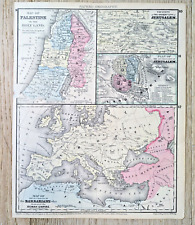 Mitchell 1875 Map Palestine Holy Land Jerusalem Barbarians Roman Empire
-
$309.12 CAD
 1843 Rare Original Map of United States, Mexico and Cuba
-
$38.47 CAD
 1831 Spain / Catalonia antique map SDUK engraved by J C Walker
-
$343.46 CAD
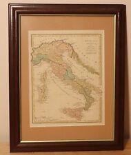 1815 Italy of antiquity by R. Wilkinson - beautiful antique framed map - London
-
$54.94 CAD
 1839 Stieler Physical Map Europe River Basins Mountain Ranges Rhine Danube Seine
-
$103.04 CAD
 1840 Antique South America Map Amazon Peru Bolivia Brazil Andes SDUK London
-
$136.01 CAD
 1812 Lapie Map of Great Britian Scotland and Ireland
-
$2679.01 CAD
 Map California, Territories of Oregon, Washington, Utah, New Mexico DeSilver1859
-
$96.17 CAD
 1820 Ancient Greece antique map by Lavoisne ~ 21.8" x 17.5" hand colored
-
$43.74 CAD
 1838 MAP - ITALY Piedmont France Savoy Land of Neff 13.5 x 16.6" 34 x 42 cm
-
$171.73 CAD
 1830 Pacific Ocean - islands coasts & US antique map by Huntington ~ 11" x 8.25"
-
$109.91 CAD
 1820 Asia China India Mongol + antique map by Lavoisne 21.8" x 17.6" hand color
-
$116.78 CAD
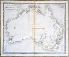 Australia Antique Map circa 1850 by Sidney Hall Engraved Outline Color
-
$27.46 CAD
 1873 Steinwehr Physical World Map Mountains Plateaus Plains America Europe Asia
-
$89.30 CAD
 1820 Germany antique map by Lavoisne / Carey 21.8" x 17.5" hand color
-
$96.17 CAD
 1820 China & Korea antique map by Lavoisne 21.8" x 17.6" hand color
-
$67.32 CAD
 1863 Johnson's PALESTINE Antique Map Hand Colored 14 x 18"
-
$98.92 CAD
 Der Hauptpass durch den Balkan Antique Map Engraving Mountain Massif Veduta 1840
-
$57.41 CAD
 1825 John Russell Antique Map of Scotland
-
$67.32 CAD
 1863 Johnson's Map of Maryland and Delaware District of Columbia 14 x 18"
-
$94.80 CAD
 1863 Johnson's PRUSSIA NORWAY SWEDEN and DENMARK Hand Colored 18" x 26"
-
$57.41 CAD
 1845 Louis Dussieux Large Antique Physical Map of Europe UK to Russia & Italy
-
$136.01 CAD
 1863 JOHNSON'S ROMAN EMPIRE,IMPERIUM ROMANORUM LATISSIME PATENS 18 x 26"
-
$42.30 CAD
 1847 Vuillemin Antique Map The Turkish Empire in Europe from Greece to Austria
-
$68.69 CAD
 1820 Hindostan / India by Warner & Cary - 8.8" x 8.2" Authentic & original map
-
$343.46 CAD
 1828 Asia Full Color Brue Map 26.5" x 20.8" - Rare Antique Original - China
-
$39.73 CAD
 FRANCE In The Year 1570 To Illustrate St. Bartholomew Eve MAP Normandy Champagne
-
$151.12 CAD
 1820 India Hindoostan antique map by Lavoisne / Carey 21.8" x 17.6" hand color
-
$75.56 CAD
 1820 Canaan & Egypt antique map by Lavoisne ~ 21.8" x 17.5" hand colored
-
$61.82 CAD
 1780 Europe by Raynal / Bonne 14.1" x 9.75" authentic antique map
-
$57.41 CAD
 1816 Aaron Arrowsmith Antique Map of South America
-
$24.72 CAD
 1804 Copper Engraving Hand Colored Map Netherlands France Darton & Harvey
-
$68.69 CAD
 1820 Denmark Sweden Iceland + antique map by Lavoisne 21.8" x 17.6" hand color
-
$61.12 CAD
 1856 NICE ORIGINAL MAP World Eastern Hemisphere ASIA EUROPE AUSTRALIA AFRICA
-
$21.98 CAD
 1860 Johnson Map - World Animal Kingdom Birds - Productive Industry Agriculture
-
$48.08 CAD
 1820 South America - original engraved map by Blondeau, Amérique Méridionale
-
$123.65 CAD
 1820 Empire of Russia antique map by Lavoisne 21.8" x 17.6" hand color
-
$89.30 CAD
 1820 Netherlands antique map by Lavoisne / Carey 21.8" x 17.3" hand color
-
$27.46 CAD
 1849 Bilder Atlas Physical Map Africa Ocean Wind Currents Kong Mountains Sahara
-
$123.65 CAD
 1820 Poland & Hungary antique map by Lavoisne 21.8" x 17.6" hand color
-
$27.46 CAD
 1873 Steinwehr World Map Animal Regions Biomes Zones Rain Forest Arctic America
-
$21.97 CAD
 1863 Warren Physical World Map Distribution of Rain Snow Chamouni Glacier India
-
$54.95 CAD
 c 1800 Barbary coast "Cotes De Barbarie" Delamarche antique map
-
$43.95 CAD
 1846 Stieler Map Germany Switzerland Austria Italy France Alps Mountain Summits
-
$21.98 CAD
 1849 Bilder Atlas Physical Map - Central Europe Rivers & Mountains Alps Rhein
-
$116.78 CAD
 1820 Ireland antique map by Lavoisne 21.8" x 17.3" hand color
-
$32.96 CAD
 1892 Stieler Map North South Dakota Nebraska Minnesota Iowa United States Canada
-
$27.46 CAD
 1843 Woodbridge Map Germany Austria Bohemia Prussia Berlin Hamburg Switzerland
-
$54.89 CAD
 Asian Physics Old Map Himalayas, Asie Physique 1887
-
$428.21 CAD
 "CARTE DES ILES SALOMON", VINCENDON DUMOULIN, from Dumont d'Urville Voyage, 1842
-
$377.81 CAD
 1828 China & Japan empires full color Brue map 26.5" x 20.8" Rare Antique
-
$61.82 CAD
 1820 Roman Empire antique map by Lavoisne ~ 21.7" x 17.5" hand colored
-
$151.12 CAD
 1820 North & South America antique map by Lavoisne ~ 21.8" x 17.6" hand colored
-
$32.96 CAD
 1873 Steinwehr Physical World Map Rivers Lakes Oceans Water Hydrography Earth
-
$27.46 CAD
 1843 Woodbridge Map Europe France Spain Germany Italy Sweden Norway Austria UK
-
$27.46 CAD
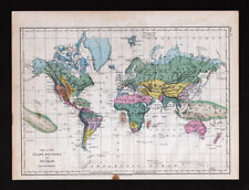 1873 Steinwehr World Map Plant Regions Floral Biomes Zones Rain Forest Deserts
-
$24.72 CAD
 1803 Copper Engraving Hand Colored Map Southern Russia Europe Turkey Asia
-
$27.46 CAD
 1843 Woodbridge Physical Map Europe France Spain Germany Italy Sweden Austria UK
-
$94.80 CAD
 1862 Johnson Map of Austria, Turkey in Europe and Greece Hand Colored 18" x 26"
-
$103.04 CAD
 1820 Europe Iberia to Russia antique map by Lavoisne ~ 21.8" x 17.4" hand color
-
$171.73 CAD
 1844 D.F. Robinson Antique Map Olney School Atlas WORLD MAP Continents Countries
-
$54.95 CAD
 c 1800 Hungary "Royaume du Hongri" Delamarche antique map
-
$33.23 CAD
 1825 Sydney Hall Antique Map of Africa
-
$517.42 CAD
 "CARTE DE LA CÔTE SUD-OUEST DE LA NOUVELLE GUINÉE", VINCENDON DUMOULIN, 1842.
-
$41.20 CAD
 c 1836 Russia in Europe by J. Dower / Orr - 11.2" x 9.1" authentic antique map
-
$61.82 CAD
 1827 Europe in 12 Sheets # 6 Russia by J. Mawman - 16.8" x 10.6" authentic map
-
$27.46 CAD
 1873 Steinwehr Physical World Map Volcanoes Volcanic Activity Regions Ring Fire
-
$99.99 CAD
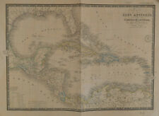 BRUÉ Map of Caribbean Carte des Isles Antilles des Etats Unis de L'Amérique 1860
-
$874.27 CAD
 "CARTE DE LA ROUTE...À TRAVERS LE DÉTROIT DE TORRES" VINCENDON DUMOULIN, 1842.
-
$61.82 CAD
 Original 1832 Switzerland - Brue Atlas 26" x 21" huge map - Antique
-
$343.46 CAD
 1812 South America by Omadilla / Kneafs - 10.9" x 8.4" original antique map rare
-
$54.89 CAD
 1856 Boynton Map Distribution of Global Vegitation for Cartee's Physical Geograp
-
$53.58 CAD
 1862 Johnson Map of the World Ocean Currents Tidal Lines - Hand Colored 14 x 18"
-
$103.04 CAD
 1820 Europe Barbarian Incursion antique map by Lavoisne 21.8" x 17.6" hand color
-
$116.78 CAD
 1820 South America antique map by Lavoisne / Carey 21.6" x 17.3" hand color
-
$1115.14 CAD
 CARTE DES EXPLORATIONS DANS LES REGIONS CIRCUM-POLAIRE, VINCENDON DUMOULIN, 1842
-
$981.32 CAD
 "CARTE DE L'ILE DE BORNEO", VINCENDON DUMOULIN, Dumont d'Urville Voyage, 1842.
-
$65.94 CAD
 1892 Stieler World Map - North Pole Arctic Ocean Greenland Canada Siberia Alaska
-
$13.67 CAD
 Newsweek Map of the Month August 1966 "The Legacy of Crisis" 35" x 44"
-
$17.20 CAD
 1838 FRENCH MAP of GERMANY- L'ALLEMAGNE- AUSTRIA GOOD CONDITION FOR AGE
-
$83.10 CAD
 1817 Aaron Arrowsmith Antique Map of South America
-
$27.48 CAD
 1872 S.A. Mitchell map "IOWA and MISSOURI"
-
$27.48 CAD
 1861 Colton's "Argentine Republic, Chili, Uruguay & Paraguay"-original,
-
$34.35 CAD
 1861 Colton's "Peru & Bolivia"-original, ex-atlas
-
$96.16 CAD
 Newsweek Map of the Month August 1967 43x34
-
$27.48 CAD
 1872 S.A. Mitchell map "OHIO & INDIANA"
-
$12.36 CAD
 1897 (98) Nevada and Utah by The Century Co,
-
$122.27 CAD
 1863 Johnson's EUROPE by Johnson and Ward hand colored 18" x 26"
-
$27.48 CAD
 1884 Steiler Map: South East Australia: New S. Wales, Queensland & S Australia
-
$27.13 CAD
 1864 S.A. Mitchell "New Hampshire & Vermont"
-
$52.21 CAD
 1863 JOHNSON'S BRAZIL ARGENTINE REPUBLIC,PARAGUAY AND URUGUAY hand col 14" x 18"
-
$75.56 CAD
 Map of The Country Northwest of Boston 1896 ORIGINAL by The Appalachian Club


