 Antiques (CA)
-
$340.58 CAD

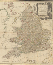
 Antique Map-South England and counties-London-Sussex-Kent-Wales-Sanson-ca. 1720
-
$225.23 CAD
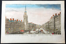 1760 Vue D Optic Large Antique Print View of Cheapside, London St Mary le Bow
-
$135.14 CAD
 1812 Lapie Map of Great Britian Scotland and Ireland
-
$94.19 CAD
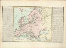
 Original Antique 1780 Map of Europe by Bonne
-
$95.55 CAD
 Eighteenth Century Hand-Col. Map of London & Environs, 1787 - PRICE REDUCED
-
$54.60 CAD
 1756 "The London Magazine" - Kitchin Map of Anglesey - Christopher Wren -Minorca
-
$150.16 CAD
 LONDON VAUXHALL GARDEN c. 1760 LARGE ANTIQUE OPTICAL VIEW 18TH CENTURY
-
$129.68 CAD
 Antique Map The Road from London to New Haven in Sussex England Hand Colored Map
-
$375.39 CAD
 A New Map of the Kingdoms of Spain and Portugal with Their Principal Divisons…
-
$399.00 CAD
 Bellin 1759 Map of the Entrance to the River Thames UK
-
$109.20 CAD
 LONDON ST JAMES PARK c. 1750 LARGE ANTIQUE OPTICAL VIEW IN COLORS 18TH CENTURY
-
$136.50 CAD
 1767 Europe's Lakes, Rivers & Mountains antique map by Clouet ~ 22.7" x 16.6"
-
$111.91 CAD
 1790 Cary Road Map 3/4 Brentford Hounslow Belfont Staines Egham Virginia Water
-
$87.02 CAD
 London to St. David's Pembrokeshire Wales 1775 Bowen engraved road map travel
-
$87.02 CAD
 London to Barnstable to Truro Cornwall 1775 Bowen engraved road map travel
-
$300.31 CAD
 1722 Robert Morden Antique Map of The English County of Middlesex, London
-
$61.43 CAD
 18th century Surrey England Antique Map by Thomas Kitchin
-
$109.19 CAD
 1755 CITY OF LONDON MAP BY BENJAMIN COLE- CORDWAINER & BREAD STREET WARDS
-
$204.76 CAD
 LONDON CITY HALL c. 1760 LARGE ANTIQUE OPTICAL VIEW 18TH CENTURY
-
$44.98 CAD
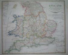
 1794 ENGLAND & WALES ROBERT WILKINSON ORIGINAL HAND COLORED MAP EX. COND.
-
$65.51 CAD
 1796 Blondeau Map England Wales London Bristol Oxford Salisbury Manchester
-
$37.34 CAD
 Somerset House London View Engraving Copperplate Van Der Aa 1707
-
$111.91 CAD
 1790 John Cary Antique London Road Map - General Map showing Roads from London
-
$61.43 CAD
 18th century Westmoreland England Antique Map by Thomas Kitchin
-
$94.19 CAD
 1764 MAP OF COUNTRIES THIRTY MILES ROUND LONDON antique 12.5 by 15"
-
$136.50 CAD
 1767 Europe's Islands Capes & Seaports antique map by Clouet ~ 23" x 16.8"
-
$61.43 CAD
 1780 Europe by Raynal / Bonne 14.1" x 9.75" authentic antique map
-
$150.16 CAD
 LONDON WESTMINSTER BRIDGE c. 1750 LARGE ANTIQUE OPTICAL VIEW 18TH CENTURY
-
$120.11 CAD
 1756 Maitland Antique Print of Bridewell Palace, London, England Henry VIII
-
$409.50 CAD
 AUTHENTIC LARGE COLOR MAP FROM 18TH CENTURY - Museum Grade Quality
-
$163.66 CAD
 1793 Cary Antique Map of The English County of Middlesex - London & River Thames
-
$42.03 CAD
 1720 Emmanuel Bowen Antique British Road Map - London, Cobham, Guildford Surrey
-
$1911.07 CAD
![Battle of the Nile, at 10 O’clock at Night [...]](https://i.ebayimg.com/thumbs/images/g/zGUAAOSwKKtlw3qA/s-l225.jpg) Battle of the Nile, at 10 O’clock at Night [...]
Battle of the Nile, at 10 O’clock at Night [...]
-
$61.43 CAD
 18th century Stirling and Clackamannan Counties in Scotland Antique Map
-
$27.29 CAD
 ANTIQUE 1775 BERKSHIRE ABINGTON MONMOUTH LONDON ENGLAND COPPERPLATE ROAD MAP NR
-
$71.65 CAD
 1823 ORIGINAL MAP UNITED KINGDOM ENGLAND WALES LONDON CAMBRIDGE LANCASTER YORK
-
$47.78 CAD
 1856 ORIGINAL MAP UNITED KINGDOM GREAT BRITAIN IRELAND ENGLAND SCOTLAND WALES
-
$78.48 CAD
 1823 ORIGINAL MAP IRELAND UNITED KINGDOM ENGLAND WALES SCOTLAND DUBLIN LONDON
-
$120.11 CAD
 1773 Francis Grose Large Antique Print of The London Charterhouse, Farringdon
-
$42.03 CAD
 1753 Gentlemans Magazine Antique Print View of London Lord Mayor Residence
-
$122.85 CAD
 ABBAYE OF WESTMINSTER LONDON DATED 1753 LARGE ANTIQUE OPTICAL VIEW 18TH CENTURY
-
$88.73 CAD
 1767 British Isles / England antique map by Clouet ~ 22.7" x 16.7" - hand color
-
$136.50 CAD
 LONDON ST PAUL'S CATHEDRAL 1750 POILLY LARGE ANTIQUE OPTICAL VIEW 18TH CENTURY
-
$57.05 CAD
 1780 History of England Original Antique Frontispiece, Title Page - Britannia
-
$819.03 CAD
 1743 MAP OF EUROPA CONTINENT HOMANN HEIRS ORIGINAL COLORED COPPERPLATE
-
$204.76 CAD
 ST MARTINS-IN-THE-FIELDS LONDON c. 1760 LARGE ANTIQUE OPTICAL VIEW 18TH CENTURY
-
$271.64 CAD
 England & Wales 1780s antique map by Carington Bowles - Correct Guide
-
$107.41 CAD
 Middlesex County England London Zatta Map Card Copperplate Engraving 1779
-
$682.52 CAD
 Greece Archipelago and part of Anadoli. By L.S. de la Rochette. MDCCXC. London
-
$204.76 CAD
 LONDON THAMES c. 1760 LARGE ANTIQUE OPTICAL VIEW 18TH CENTURY
-
$57.05 CAD
 1755 Maitland Antique Print Ironmongers Hall & South Sea House, London, England
-
$204.76 CAD
 LONDON 1750 LARGE ANTIQUE OPTICAL VIEW IN COLORS 18TH CENTURY
-
$204.76 CAD
 ST JAMES'S PARK LONDON c. 1760 LARGE ANTIQUE OPTICAL VIEW 18TH CENTURY
-
$204.74 CAD
 1754 Copper Engraving of Tower Liberty Tower of London
-
$170.63 CAD
 Original 1785 Map of Coleman St, Bassishaw Wards, Portsoken Ward, Cripplegate
-
$204.76 CAD
 ROYAL PROCESSION LONDON c. 1760 LARGE ANTIQUE OPTICAL VIEW 18TH CENTURY
-
$170.63 CAD
 Original 1785 Map of Cheap Ward and Tower Street Ward, Thornton's Survey London
-
$68.25 CAD
 1736 Ogilby /Bowen The Road from London to Weymouth come Dorset
-
$42.03 CAD
 1753 Gents Mag Antique Print Bridges x 2 at Hampton Court & Huntington, England
-
$245.71 CAD
 1785 Johann Probst Map Great Britain England Scotland Wales Ireland London UK
-
$38.18 CAD
 Dec. 1751 Antique Map//COUNTY DURHAM, ENGLAND//London Magazine
-
$204.76 CAD
 CUSTOM HOUSE LONDON DATED 1753 LARGE ANTIQUE OPTICAL VIEW 18TH CENTURY
-
$57.05 CAD
 1720 Emmanuel Bowen Antique British Road Map - London to Bagshot in Surrey
-
$750.78 CAD
 LONDON ENGLAND 1700 NICOLAS DE FER NICE ANTIQUE ENGRAVED CITY MAP 17TH CENTURY
-
$38.18 CAD
 July 1754 Antique Map//COUNTY CARDIGANSHIRE, WALES//London Magazine
-
$49.54 CAD
 1755 Maitland Antique Print Fishmongers & Bancroft Alms Houses Surrey, London
-
$163.81 CAD
 Antique Map Middlesex England Circa 1701 by John Seller Hand Tinted Engraving
-
$81.90 CAD
 Antique Map of Nomandie France, Southern England, English Channel 1797 Italian
-
$27.29 CAD
 1707 Pieter Van Der Aa Limited Edition Map England River Thames London 292/400
-
$53.37 CAD
 1790 Norfolk Suffolk Essex Kent London Surrey England Map Card Reilly
-
$1201.24 CAD
 An Accurate Map of Great Britain, France & Ireland LONDON Laurie & Whittle 1794
-
$266.18 CAD
 Vintage c.1773 MAP OF SCOTLAND & HEBRIDES Old Antique Original PUBLISHED c.1830
-
$129.68 CAD
 Antique 1776 London England Rare Road Map
-
$95.49 CAD
 Framed Middlesex London BY JOHN CARY GENUINE ANTIQUE ENGRAVED MAP c1787
-
$266.18 CAD
 1780 Kingdoms of England Scotland & Ireland antique map by Bonne/Lattre - framed


