 Antiques (CA)
-
$79.78 CAD

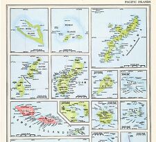 1956 Pacific Islands Map Fiji Guam Samoa Okinawa Iwo Bikini Palau Tinian
-
$16.16 CAD
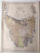
 1966 AUSTRALIA Atlas Map, vintage World Book Atlas, color, physical, Tasmania
-
$79.78 CAD
 1956 Australia Map Melbourne Sydney Adelaide Brisbane Rockhampton Newcastle
-
$16.16 CAD
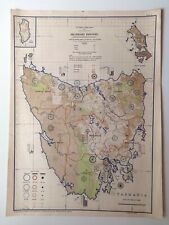
 1966 AUSTRALIA Atlas Map, vintage World Book Atlas, color, political, Tasmania
-
$8.24 CAD
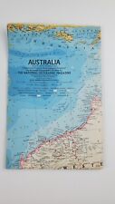
 Vintage Lithography Map of Antarctica - National Geographic 1957 - South Pole
-
$34.32 CAD
 ITMB International Travel Maps AUSTRALIA - 2002 Third Edition -
-
$75.66 CAD
 1834 Dumont d'Urville Engraved Map ~ Carte des Iles TAHITI ~ Society Islands
-
$343.89 CAD
 1934 Vintage Pictorial Map - SECOND BYRD ANTARCTIC EXPEDITION - George Annand
-
$67.24 CAD
 1945 Vernon Quinn Pictorial Map ~ POLYNESIA - TAHITI ~ Maps by Frank Beaudouin
-
$39.89 CAD
 c.1930s Val Morgan & Sons Official Map Melbourne and Suburbs Australia Vintage
-
$30.26 CAD
 Tasmania, New Guinea Fiji, Samoa & NZ - Large Original 1926 Map by George Philip
-
$30.97 CAD
 Broadbent's 1956 Victoria & Riverina Vintage Large Scale Folding Map No 320
-
$33.01 CAD
 Australia - Original 1937 German Language Map by Velhagen & Klasing. Vintage
-
$16.16 CAD
 1966 PACIFIC ISLANDS Atlas Map, vintage World Book Atlas, full color
-
$22.23 CAD
 1937 Vintage Australia Map Atlas Map of Australia Gallery Wall Decor 1063
-
$92.93 CAD
 1945 Tasmania, Australia, Distribution of Soil Types, Map No 4
-
$39.73 CAD
 1962 Pictorial Maps of CHINA, TIBET, MONGOLIA, MANCHURIA F. BEAUDOUIN & V. QUINN
-
$23.38 CAD
 Australia - Original 1931 German Language Map by Meyers. Vintage
-
$7.96 CAD
 VINTAGE LIGHTNING RIDGE MAP AND GUIDE NSW AUSTRALIA BLACK OPALS EPHEMERA
-
$30.12 CAD
 1897 ORIGINAL VINTAGE MAP Samoa Islands Meyers Konversations-Lexikon C10-5
-
$27.51 CAD
 1942. VINTAGE FOLDING MAP. AUSTRALIA. WESTERN AUSTRALIA
-
$20.63 CAD
 Vintage Australia 1965 US Army Topographic Map 1:5,000,000
-
$20.56 CAD
 Hawaii Map 1899 Honolulu and Vicinity
-
$26.14 CAD
 Pacific Islands - Original 1928 German Language Map by Meyers. Oceania Vintage
-
$20.50 CAD
 Antique 1899 Color Map Pacific Ocean and Oceania 11" X 16" #4155
-
$20.50 CAD
 Antique 1899 Color Map Luzon Philippine Islands 11" X 16" #4156
-
$92.93 CAD
 1945 Tasmania, Australia Secondary Industry Crown Lands State Forests, Map No 18
-
$92.93 CAD
 1945 Tasmania Australia Livestock Distribution Horse Cattle Pigs Sheep Map No 11
-
$337.01 CAD
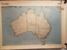
 1991 Large Vintage School Map - Australia,New Zealand Physical and Economic Map
-
$92.93 CAD
 1945 Tasmania, Australia, Cattle Distribution other than Dairy Cows, Map No 10
-
$92.93 CAD
 1945 Tasmania Australia, Dairying Industry, Dairy Cows, Cheese, Butter, Map No 9
-
$13.73 CAD
 1950's Cram's Modern Series Pocket Fold-out Map Italy and San Marino 359 Vintage
-
$21.53 CAD
 1921 OCEANIA Map. HAWAII, AUSTRALIA, NEW ZEALAND. Neutral Colors Tan, Turquoise.
-
$27.44 CAD
 Vintage 1895 Oceanica Map Original 14.5 inch By 11 inch Pacific
-
$110.04 CAD
 1940s Australian Pictorial Map, Queensland, Expected Growth etc.
-
$41.20 CAD
 Robinson's Queensland Road Map (5th Edition) - 40 x 30 In. - Very Good Condition
-
$34.37 CAD
 vintage NEW ZEALAND SOUTH ISLAND MOTOR TOURING MAP 1959
-
$137.55 CAD
 SOUTHEAST ASIA OCEANIA PACIFIC SETTLEMENTS & DENSITY c. 1950 LARGE WALL MAP
-
$67.24 CAD
 1945 Vernon Quinn Pictorial Map POLYNESIA - MICRONESIA ~ Maps by Frank Beaudouin
-
$67.24 CAD
 1945 Vernon Quinn Pictorial Map POLYNESIA - MELANESIA ~ Maps by Frank Beaudouin
-
$67.24 CAD
 1943 Vernon Quinn Pictorial Map THE PHILIPPINE ISLANDS ~ Maps by Frank Beaudouin
-
$67.24 CAD
 1945 Vernon Quinn Pictorial Map ~ INDONESIA ~ Maps by Frank Beaudouin
-
$17.18 CAD
 1963 VINTAGE MAP OF AUSTRALIA NATIONAL GEOGRAPHIC
-
$34.39 CAD
 Large Vintage Map Of Australia Rand Mcnally 44"×31"
-
$67.24 CAD
 1945 Vernon Quinn Pictorial Map ~ MICRONESIA ~ Maps by Frank Beaudouin
-
$137.55 CAD
 INDONESIA OCEANIA AUSTRALIA PACIFIC 1950 COMMERCIAL LARGE WALL MAP
-
$67.24 CAD
 1945 Vernon Quinn Pictorial Map THE HAWAIIAN ISLANDS ~ Maps by Frank Beaudouin
-
$137.55 CAD
 SOUTHEAST ASIA INDONESIA OCEANIA PACIFIC SETTLEMENTS-DENSITY 1950 LARGE WALL MAP
-
$55.02 CAD
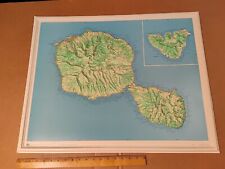 Vintage 1974 IGN France Molded Plastic Tahiti Papeete Moorea School Map
-
$61.90 CAD
 1899 Pacific Ocean & Oceania Map - J Martin Miller Chicago, Illinois Print
-
$63.84 CAD
 Route map Travl Guide Papua & New Guinea with Trans Australia Airlanes
-
$151.31 CAD
 1951 U.S. Air Force Aeronautical Map of Maug Islands, Mariana Islands, Pacific


