 Antiques (CA)
Africa Maps
Asia Maps
Australia/Oceania Maps
Celestial Maps
Central America/Caribbean Maps
Curiosities Maps
Digital Maps
Europe Maps
Map & Globe Mixed Lots
Map & Globe Reproductions
North America Maps
South America Maps
World & Celestial Globes
World Maps

-
$103.88 CAD

 Sable Island Canada Navigation 1816 Blunt nice HC coastal nautical map
-
$136.69 CAD
 Little Egg Harbor New Jersey Tucker's Beach 1837 Blunt Hooker nautical map
-
$78.05 CAD
 Classy Desk Decor Vintage Collectable Brass Antique Style World Map Globe Office
-
$65.61 CAD
 Mosquito Inlet Florida Massacre Bluff 1851 U.S. Coast Survey nautical map
-
$676.59 CAD
 1916 antique ELDRIDGE MAP linen backed GLOUCESTER to KENNEBEC RIVER 24.5"x67"
-
$341.71 CAD
 Original 1851 Coast Survey Chart North Carolina Outer Banks
-
$546.74 CAD
 Original 1855 Coast Survey Chart North Carolina Albemarle Sound Hand Colored
-
$47.84 CAD
 Vintage 1970 Map Of Marine Disasters Buzzards Bay Massachusetts Closson 20x27
-
$136.67 CAD
 1853 Falmouth Harbour Antique Sea Chart Coastal Map England South UK (1856)
-
$39.64 CAD
 Vintage Nautical Map LONG ISLAND SOUND Eastern Part, Milford to New London, CT
-
$24.30 CAD
 Vintage 1929 Coast Guard Nautical Map Galveston to Mississippi River 36 x 44"
-
$403.22 CAD
 = Heinrich Scherer (1628-1704) Atlas Novus, Map of South America
-
$54.67 CAD
 Oyster and Huntington Bays 1778 Published by an Act of Parliament Repro.
-
$92.95 CAD
 Savannah River Georgia Pennyworth's Island 1851 U.S. Coast Survey nautical map
-
$447.64 CAD
 Antique Print-SEA CHART-GREECE-ATHENS-METHANA-SPETSES-Depot de la Marine-1850
-
$47.84 CAD
 Vintage Rare Map Nautical Caribbean West Indies Tourist Promo Vibrant 11x17
-
$109.33 CAD
 Original 1780 Map Pacific Voyages of James Cook Philip Carteret William Dampier
-
$676.59 CAD
 Original 1799 Map French Ship Position war At Toulon Battle 12/18/1793 Napoleon
-
$34.16 CAD
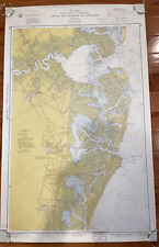
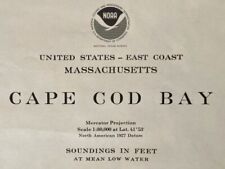 1977 Sea Chart Cape Cod Massachusetts USA Vintage Original Map Coastal Sailing
-
$88.85 CAD
 Large Watercolor Virgin Islands 1990 by J Longacre. Prof Framed And Matted 36x28
-
$7.18 CAD
 West Indies Caribbean Sea Map - Replica- Full Color - 22"x17"
-
$403.22 CAD
 = JAN JANSSON (1588-1664) - c. 1640 Tinted Map of WEST AFRICA GUINEA
-
$54.66 CAD
 1853 Gunnison Survey Map FOR NEW CHANNEL FROM MILWAUKEE RIVER TO LAKE MICHIGAN
-
$32.79 CAD
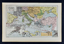 c 1885 Hartleben Map Mediteranean Sea Steamer Routes Marseille Europe Africa
-
$164.02 CAD
 Gloucester Harbor coastal Massachusetts c. 1910-15 nautical navigation hc map
-
$80.64 CAD
 Original 1950s Nautical Chart Map,Lake Borgne,Mississippi,Louisiana,Cat Island
-
$102.51 CAD
 1960 Vintage Nautical Map Atlantic City to Cape May NJ Shore C.&G.S. 38”x24
-
$49.89 CAD
 1967 FLORIDA AND BAHAMAS Operational Nav Chart HUGE Map ONC H-25 - 41"x57"
-
$80.33 CAD
 Antique Nautical Brass Armillary Sphere Arrow Globe Brown Metal Base Office Deco
-
$191.36 CAD
 Savannah River Georgia Tybee Island 1816 Blunt hand color nautical map
-
$80.53 CAD
 11" Nautical Brass Armillary Sphere World Globe Rosewood Base Home Decorative
-
$450.38 CAD
 Antique Print-SEA CHART-AFRICA-CALABAR-NIGERIA-CAMEROON-GABON-Thronton-Lamb-1707
-
$43.74 CAD
 1962 Department of the NAVY H.O. 1400 PILOT CHART OF THE NORTH ATLANTIC OCEAN
-
$41.01 CAD
 Vintage - NOAA 1993 35th Ed Nautical Map - Approaches to New York 12300 Unfolded
-
$20.49 CAD
 Nautical Map of West End of Lake Erie for traning purpose only
-
$27.27 CAD
 1851 US Coast Survey Map,Point Pinos,Monterey Bay,Califirnia,proposed Lighthouse
-
$136.67 CAD
 1860 Scilly Isles Antique Sea Chart Coastal Map England West UK (1866)
-
$82.01 CAD
 Original 1950s Nautical Chart Map,Bermuda Approaches, Seas,Old,Naval Exercises
-
$80.51 CAD
 6" Antique Replica Brass World Map Globe with Arrow on Wooden Base/Home & Office
-
$273.36 CAD
 American Revolution 1775-1783 Atlas 18th Century Maps Charts Set of 20
-
$8.20 CAD
 Vintage Chesapeake Bay 1977 Cedar Point Cove Hydrographic Map 39” x 24” Folded
-
$20.43 CAD
 1851 U S Coast Survey Map,Sandy Hook,NJ,1779-1851,Coves,Lighthouse,changes,Head
-
$68.33 CAD
 1764 nice ORIGINAL NAUTICAL MAP CROATIA ISTRIA ISTRA CRES Rijeka Fiume ITALY
-
$30.97 CAD
 world map atlas globe earth compass art print photo rustic painting vintage
-
$54.66 CAD
 Vintage Africae nova descriptio 1672 By WILLEM JANSZOON BLAEU (Print Poster)
-
$34.16 CAD
 Original 1902 WORLD MAP Colonial Possessions Steamship Routes Submarine Cables
-
$103.88 CAD
 Western Florida Tampa Bay Florida Keys 1851 U.S. Coast Survey nautical map
-
$54.65 CAD
 1944 Nautical Chart Map #1247 Bethel Shoal to Jupiter Inlet Florida 34" x 47"
-
$68.33 CAD
 Original 1853 Coast Survey Soundings Map HORN ISLAND PASS Pascagoula Mississippi
-
$198.19 CAD
 Cayenne Island French Guiana, Antique Cartography, Bellin 1764
-
$225.53 CAD
 1801 Gustaf Klint Large Map Sea Chart Celtic Sea Ireland to Bristol, Cornwall et
-
$27.34 CAD
 Lot Of 3 Lake Michigan Maps NOAA Charts
-
$102.49 CAD
 1945 Nautical Chart Map Northwest Pacific Ocean Japan Hawaii Russia Restricted
-
$68.33 CAD
 Original 1861 Coast Survey Shipwreck Map COOS BAY Oregon Soundings Tide Table
-
$75.16 CAD
 1764 rare nice ORIGINAL NAUTICAL MAP GREECE HARBOR ATHENS
-
$34.16 CAD
 Original 1881 Survey Map MOUTH OF THE COLUMBIA RIVER Oregon Soundings Breakers
-
$170.84 CAD
 1850 Guysborough Harbour Nova Scotia Antique Sea Coastal Map NS Canada (1859)
-
$20.43 CAD
 71 Historic Nautical Atlases 1500's to 1800's North America Indies Cuba CD - B93
-
$103.88 CAD
 Tampa Bay Florida Keys Western Florida Coast 1851 U.S. Coast Survey nautical map
-
$32.80 CAD
 Antique Map "Plan du Port de NAUSSA" 1776 ORIGINAL OLD
-
$136.67 CAD
 1856 Fowey Harbour Antique Sea Chart Coastal Map England South UK (1875)
-
$170.17 CAD
 Britain Map Coppercraft Copper Etchings Pleasure Reproductions BB205
-
$1705.15 CAD
 Rare Antique Map-PERSIA-CASPIAN SEA-AZERBAIJAN-RUSSIA-Pieter van der Aa-1725
-
$1144.74 CAD
 Rare Antique Print-CANADA-GULF OF ST LAURENCE-BELLE ISLE-Bellin-1753
-
$38.27 CAD
 Vintage Nautical Marine Map New York Harbor 1970s. Sam Epstein original owner
-
$170.86 CAD
 1941 Nautical Chart Hilo Bay Hawaii Restricted WWII 25" x 27" #4103
-
$40.99 CAD
 1913 Map CENTRAL AMERICA CARIBBEAN Panama Canal Steamship Route Coaling Stations
-
$47.84 CAD
 Vintage Sportsman Fishing Map of Leesville and Grands Isle LA
-
$437.39 CAD
 CAPE HORN TIERRA DEL FUEGO 1885 (1891) VERY LARGE ANTIQUE SEA CHART 19TH CENTURY
-
$136.67 CAD
 1898 Isle of Wight Antique Sea Chart Blue Back Coastal Map UK Norie & Wilson
-
$123.02 CAD
 ALICANTE SPAIN 1764 JOSEPH ROUX ANTIQUE ENGRAVED SEA CHART 18TH CENTURY
-
$95.68 CAD
 PAPUA NEW GUINEA 1774 TRAVEL OF COOK LARGE ANTIQUE ENGRAVED MAP XVIIIe CENTURY
-
$136.67 CAD
 1890 Bigbury Bay Exmouth Antique Sea Chart Coastal Map England South UK (1891)
-
$40.94 CAD
 1851 US Coast Survey Map of Mouth of Columbia,California,soundings,other rivers
-
$1031.29 CAD
 3 Antique Prints-SEA CHART-ENGLAND-THAMES-SCOTLAND-SET-EAST COAST-Imray-1879
-
$19.99 CAD
 Dial-A-Course Lake Ontario Nautical Maritime Map Boating Toronto Kingston Guide
-
$74.36 CAD
 Guilford Connecticut Mulberry Pt. c.1900-10 Eldridge nautical chart antique map
-
$82.01 CAD
 Philippine Islands Sarangani islands Mindanao 1902 small nautical chart map
-
$177.69 CAD
 VENDEE SABLES D'OLONNE 1828 VERY LARGE ANTIQUE SEA CHART 19TH CENTURY
-
$123.02 CAD
 Vintage Mid-Century Laurie Whittle Repro. Nautical Captain Map of Virgin Islands
-
$410.06 CAD
 INDIAN OCEAN 1889 (1895) VERY LARGE ANTIQUE SEA CHART 19TH CENTURY
-
$60.14 CAD
 Hatteras Inlet North Carolina 1851 U.S. Coastal Survey nautical map
-
$25.20 CAD
 Map Of The World 1884 Thermal Tidal Chart Victorian Lithograph Antique DWP3D
-
$102.51 CAD
 Vintage SEACRAFT MAP Framed Glass Tray San Juan Islands Brass Cleat Handles
-
$164.02 CAD
 MAHON MINORCA 1764 JOSEPH ROUX ANTIQUE ENGRAVED SEA CHART 18TH CENTURY
-
$12.30 CAD
 1921 Cape Porpoise Maine Harbor Chart Bickfords Island Map Goat Island Folly Isl
-
$80.64 CAD
 Circa 1970s Portsmouth Harbor,Cape Neddick,Isle Of Shoals Nautical Chart Map,NH
-
$68.33 CAD
 1903 Isle of Wight Antique Sea Chart Blue Back Map UK Imray Norie & Wilson
-
$13.65 CAD
 Route Chart Illustrating Routes Described In Hydrographic Office US Navy Map 129
-
$170.84 CAD
 1857 Beaver Harbour Nova Scotia Antique Sea Coastal Map Atlantic Canada (1859)
-
$95.67 CAD
 Original 1863 Coast Survey Chart Map ROCKLAND HARBOR & VICINITY Maine Lighthouse
-
$41.01 CAD
 Waukegan to South Haven 2016 Lake Michigan Harbor Chart
-
$20.49 CAD
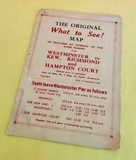 Vintage 1940's RIVER THAMES Westminster England FERRY SCHEDULE Map & Fares Slip
-
$88.85 CAD
 Original 1950s Nautical Chart Map,Grassy Bay & Ireland Islands,Bermuda,Old,Sea
-
$153.72 CAD
 Map of Romantic Boston Bay Edward Rowe Snow Salem Harbor Scituate Harbor Signed
-
$27.34 CAD
 CAPTAIN HALL'S JOURNEY King William Island Arctic Map 1879 Nunavut Canada
-
$408.69 CAD
 Antique French Navigational Sextant Hand Painted Nautical Lithograph Metal Heavy
-
$105.92 CAD
 1808 RARE ORIGINAL MAP EAST INDIES INDONESIA THAILAND MALAYSIA SIAM PHILIPPINES
-
$375.20 CAD
 Antique Print-SEA CHART-EGYPT-AFRICA-DAMIETTA-EL ARISH-Office Admirality-1857
-
$211.86 CAD
 Vintage mercantile marine atlas 14th Edition 1952


