 Antiques (CA)
Africa Maps
Asia Maps
Australia/Oceania Maps
Celestial Maps
Central America/Caribbean Maps
Curiosities Maps
Digital Maps
Europe Maps
Map & Globe Mixed Lots
Map & Globe Reproductions
North America Maps
South America Maps
World & Celestial Globes
World Maps

-
$170.75 CAD

 Britain Map Coppercraft Copper Etchings Pleasure Reproductions BB205
-
$115.89 CAD
 Oxfordshire Map Sapere Aude Copperplate Framed 1985 Janet Westman BB204
-
$102.86 CAD
 1960 Vintage Nautical Map Atlantic City to Cape May NJ Shore C.&G.S. 38”x24
-
$102.17 CAD
 Cornwall Atlantic Ocean English Channel Brass Map Framed Coppercraft BB203
-
$39.77 CAD
 Vintage Nautical Map LONG ISLAND SOUND Eastern Part, Milford to New London, CT
-
$34.27 CAD
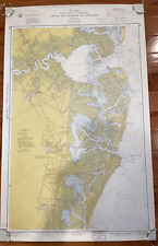
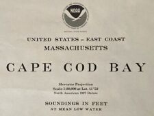 1977 Sea Chart Cape Cod Massachusetts USA Vintage Original Map Coastal Sailing
-
$27.43 CAD
 Indian Ocean Communication - Original 1926 Map by George Philip. Vintage
-
$41.14 CAD
 Vintage - NOAA 1993 35th Ed Nautical Map - Approaches to New York 12300 Unfolded
-
$20.56 CAD
 Nautical Map of West End of Lake Erie for traning purpose only
-
$43.89 CAD
 1962 Department of the NAVY H.O. 1400 PILOT CHART OF THE NORTH ATLANTIC OCEAN
-
$54.83 CAD
 1944 Nautical Chart Map #1247 Bethel Shoal to Jupiter Inlet Florida 34" x 47"
-
$102.83 CAD
 1945 Nautical Chart Map Northwest Pacific Ocean Japan Hawaii Russia Restricted
-
$171.43 CAD
 1941 Nautical Chart Hilo Bay Hawaii Restricted WWII 25" x 27" #4103
-
$68.02 CAD
 Vintage USSR Naval Military Map - Gulf of Finland & Baltic Sea - 1980s
-
$68.02 CAD
 Vintage USSR Naval Military Map No - Gulf of Finland & Baltic Sea - 1980s
-
$68.02 CAD
 Authentic Vintage USSR Naval Military Map - Baltic Sea & Gulf of Finland - 1980s
-
$48.00 CAD
 Vintage Rare Map Nautical Caribbean West Indies Tourist Promo Vibrant 11x17
-
$38.40 CAD
 Vintage Nautical Marine Map New York Harbor 1970s. Sam Epstein original owner
-
$48.00 CAD
 Vintage Sportsman Fishing Map of Leesville and Grands Isle LA
-
$102.86 CAD
 Vintage SEACRAFT MAP Framed Glass Tray San Juan Islands Brass Cleat Handles
-
$20.56 CAD
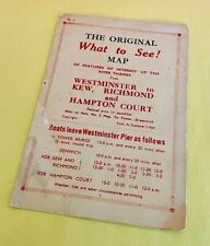 Vintage 1940's RIVER THAMES Westminster England FERRY SCHEDULE Map & Fares Slip
-
$61.72 CAD
 Original NOAA 1975 14th Ed Nautical Map GULF OF MAINE & GEORGES BANK Cape Cod
-
$61.72 CAD
 1943 US Navy Nautical Map England Southeast Coast Folkestone Harbour 4503 22x28"
-
$34.29 CAD
 C&GS Coastal Map #557 Potomac River Chesapeake Bay To Piney Point 1973 18th Ed.
-
$28.80 CAD
 Vintage 1992 Natical Chart Map Of New York, Lake Ontario, Mexico Bay, North Pond
-
$137.13 CAD
 Vintage weber costello School pull down map of the world magna-graphic steamship
-
$51.14 CAD
 Vintage Admiralty Chart ~ Cowes Harbour & River Madina Cowes To Folly Pt No.2793
-
$27.36 CAD
 1954 Japanese Hydrographic Chart Ponape & Jokaj Island Sea Chart Army Engineers
-
$68.02 CAD
 Vintage USSR Naval Military Map - Baltic Sea & Gulf of Finland - 1980s
-
$315.43 CAD
 Vintage ORIGINAL Map, Europe circa 1940 from the USA - A. Flanagan, Co-Chicago
-
$68.02 CAD
 Vintage USSR Naval Military Map - Gulf of Finland & Baltic Sea - 1980s
-
$68.02 CAD
 Vintage USSR Naval Military Map - Baltic Sea & Gulf of Finland - 1980s
-
$41.14 CAD
 1929 UNITED STATES COAST GUARD WEST INDIES AND SOUTH PUERTO RICO MAP 44X36 EX
-
$11.59 CAD
 Original 1939 Panama Canal Map by US Coast and Geodetic Survey
-
$27.43 CAD
 Newport California Chart #5108 1967 10th Ed
-
$56.23 CAD
 McCLUER GULF TANDJOENG SIBABOE SEMAI 1944 PAPAU NEW GUINEA U.S. NAVY MAP WWII
-
$34.29 CAD
 1959 US INTERCOASTAL WATERWAY ELLIOT KEY TARPON BASIN FLORIDA MAP 39X24 EX COND
-
$205.72 CAD
 1956 West Indies South Coast of Cuba Gulf of Batabano Map
-
$68.02 CAD
 Vintage Soviet Naval Map - Baltic Sea & Gulf of Finland - 1980s
-
$68.02 CAD
 Vintage USSR Naval Military Map - Gulf of Finland & Baltic Sea - 1980s
-
$33.52 CAD
 Large Map AFRICA E. Coast Kilwa Point & North Mafia Vintage Nautical Chart 1948
-
$41.13 CAD
 Vintage ORIGINAL nautical Chart, Rare, Antilles
-
$54.84 CAD
 1932 California Nautical Map West Coast Point Fermin To Point Conception 33"X46"
-
$131.66 CAD
 Nautical Chart Australia Southern Portion Tasmania Pacific Admiralty 1972
-
$123.36 CAD
 1934 Nautical Chart #3831 Bismark Archipelago New Guinea & New Britain 30" x 42"
-
$54.69 CAD
 San Francisco Bay Waterproof Chart, 3rd Edition
-
$130.29 CAD
 Danish and Swedish Coast Nautical Map 1944 Der Sund Southern Part 36x48 #478
-
$82.22 CAD
 1938 Nautical Chart #0826 South Pacific Sheet IV Australia New Guinea 34" x 49"
-
$34.27 CAD
 1976 Nautical Chart East River New York USA Vintage Map Sailing Coastal Sea
-
$54.84 CAD
 OPC Vintage The Standard Management Course Map Ports & Steamship Lines of the Wo
-
$61.72 CAD
 1951 Hydrographic Nautical Chart Port Royal to Pedro Bluff Jamaica 30 x 50" 1683
-
$12.33 CAD
 Vintage ANDERSON ISLAND WA Coastal Zone Atlas of Washington Subtidal Clam Map
-
$68.02 CAD
 Vintage Soviet Naval Map - Baltic Sea & Gulf of Finland - 1980s
-
$12.29 CAD
 Vintage USVI Maps Maritime Waterproof Nautical 35"x25" Virgin Islands 2 Large
-
$14.40 CAD
 Waterproof Chart Barrier Islands Boca Grande to Estero Bay Chart #25E SEALED NEW
-
$34.29 CAD
 Track Chart of the World Showing distances in Nautical Miles US Navy 1914
-
$34.29 CAD
 GREAT CIRCLE SAILING CHART of North Atlantic #1280 US Navy 1942 free US shipping
-
$137.15 CAD
 Vintage 1967 Map NEW YORK CITY EAST RIVER, Tallman Island to Queensboro Bridge
-
$200.22 CAD
 40x40 Vintage Nautical Map By Alexander In Beautiful Frame.
-
$68.02 CAD
 Vintage Soviet Naval Map - Baltic Sea & Gulf of Finland - 1980s
-
$68.02 CAD
 Vintage USSR Naval Military Map - Gulf of Finland & Baltic Sea - 1980s
-
$68.02 CAD
 Vintage Soviet Naval Map - Baltic Sea & Gulf of Finland - 1980s
-
$34.29 CAD
 GREAT CIRCLE SAILING CHART of the Indian Ocean #1284 free ship in US
-
$80.92 CAD
 Vintage Naval Map of Western Approaches to Orkney and Shetland Islands, UK
-
$34.29 CAD
 US Navy Hydrographic Map of North Atlantic publ. 1924 rolled
-
$27.42 CAD
 1962 Matha's Vineyard to Block Island Nautical Map #1210 Anchorage Areas 49"
-
$68.02 CAD
 Vintage USSR Naval Military Map - Gulf of Finland, Baltic Sea - 1:12,500
-
$12.33 CAD
 Vintage ISLAND COUNTY WA Coastal Zone Atlas of Washington Subtidal Clam Map
-
$8.23 CAD
 Vintage QUIMPER PENINSULA WA Coastal Zone Atlas of Washington Subtidal Clam Map
-
$8.23 CAD
 Vintage PORT DISCOVERY WA Coastal Zone Atlas of Washington Subtidal Clam Map
-
$34.29 CAD
 GREAT CIRCLE SAILING CHART of South Atlantic #1281 US Navy 1942 free US shipping
-
$8.23 CAD
 Vintage MAURY ISLAND WA Coastal Zone Atlas of Washington Subtidal Clam Map
-
$8.23 CAD
 Vintage KITSAP COUNTY WA Coastal Zone Atlas of Washington Subtidal Clam Map
-
$12.33 CAD
 Vintage KITSAP COUNTY WA Coastal Zone Atlas of Washington Subtidal Clam Map
-
$12.33 CAD
 Vintage BUDD INLET OLYMPIA WA Coastal Zone Atlas of Washington Subtidal Clam Map
-
$8.23 CAD
 Vintage PORT LUDLOW WA Coastal Zone Atlas of Washington Subtidal Clam Map
-
$116.57 CAD
 Vintage ORIGINAL nautical Chart, rare,portugal 1970's
-
$8.23 CAD
 Vintage SEABECK KINGSTON WA Coastal Zone Atlas of Washington Subtidal Clam Map
-
$8.23 CAD
 Vintage NORMANDY PARK WA Coastal Zone Atlas of Washington Subtidal Clam Map
-
$12.33 CAD
 Vintage CLALLAM COUNTY WA Coastal Zone Atlas of Washington Subtidal Clam Map
-
$116.57 CAD
 Vintage ORIGINAL nautical Chart, rare,san diego 1970's


