 Antiques (CA)
-
$82.22 CAD

 1916 UNITED STATES Map ORIGINAL LARGE Wisconsin Indiana Pennsylvania Delaware
-
$24.03 CAD
 Antique 1914 Map Of Chicago Illinois 11x15 Inches
-
$24.72 CAD
 1950 ORIGINAL VINTAGE MAP OF IDAHO / VERSO ILLINOIS CHICAGO
-
$54.76 CAD
 1916 UNITED STATES Map ORIGINAL Rainfall Colorado Montana Michigan Wisconsin
-
$63.09 CAD
 1894 Plat Map ~ WAYNESVILLE Twp., HALLSVILLE, DeWitt Co., ILLINOIS (15x17)-#015
-
$29.54 CAD
 1889 Map ~ CHICAGO, IL ~ (12x17) ~ Good Condition ~ Free S&H-#044
-
$24.72 CAD
 Illinois - Original 1882 Map by Phillips & Hunt. Antique
-
$63.09 CAD
 1894 Plat Map ~ BARNETT Twp., HALLSVILLE, DeWitt Co., ILLINOIS (15x17)-#014
-
$63.09 CAD
 1894 Plat Map ~ KENNEY Twp., DeWitt Co., ILLINOIS (15x17)-#002
-
$63.09 CAD
 1894 Plat Map ~ The CITY of CLINTON, DeWitt Co., ILLINOIS (XL17x29)-#016
-
$13.66 CAD
 1920s AURORA ILLINOIS DAILY NEWS FARM ATLAS MAP-ST. CHARLES TOWNSHIP-KANE COUNTY
-
$39.13 CAD
 1910 Plat Map New Lenox Township Will County Illinois Marley Spencer Original
-
$45.02 CAD
 1874 Map, FULTON, McDONOUGH, SCHUYLER, MASON, CASS & MENARD Co., ILLINOIS #062
-
$27.45 CAD
 USGS Topographic Map Genesco Illinois Antique Original Printed 1934 16x20 Art
-
$24.72 CAD
 1906 ANTIQUE MAP WESTERN USA CALIFORNIA IDAHO WYOMING MONTANA MICHIGAN ILLINOIS
-
$171.64 CAD
 Antique Map -ROCKFORD Illinois - Warner & Beers/Union Atlas Co. 1876
-
$68.64 CAD
 Atlas of Peoria County, Illinois 1873 By A. T. Andreas
-
$24.65 CAD
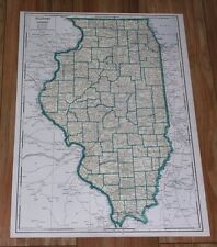
 1941 Vintage ILLINOIS Map Antique State Map of Illinois Atlas Map Decor 1583
-
$8.24 CAD
 1897 Map East part of United States Original antique print
-
$44.43 CAD
 Vintage 1902 ILLINOIS Map 14"x22" ~ Old Antique Original DIXON MOLINE GENESEO IL
-
$24.10 CAD
 1937 Vintage Chicago Illinois Street Map Wall Decor City Map of Chicago 1311
-
$39.13 CAD
 1910 Plat Map Frankfort Township Will County Illinois Mokena Original
-
$12.07 CAD
 c1870s Hand Colored Whiteside County IL Atlas Page ~ Hume Township & Como Maps
-
$240.22 CAD
 Original 1920 Schuyler County Illinois IL Atlas by Kenyon Co Plat Book
-
$24.72 CAD
 1934 Wall Map Greater Peoria Illinois and Environs Drawn byE O Pearson 22 x 17”
-
$63.09 CAD
 1910 Plat Map MINER, CIRCLEVILLE, WINKEL, LILLY, TAZEWELL Co., IL (XL17x29)-#020
-
$63.09 CAD
 1894 Plat Map ~ WAYNESVILLE Twp., DeWitt Co., ILLINOIS (15x17)-#001
-
$39.13 CAD
 1910 Plat Map Town of Frankfort Will County Illinois Stillwagon Bowen Otter
-
$54.76 CAD
 1897 Southern Illinois Map ORIGINAL Chicago Springfield Belleville Mattoon
-
$42.63 CAD
 1898 Antique CHICAGO Illinois Street Map George Cram City Map of Chicago 1531
-
$40.41 CAD
 1927 MAP OF CENTRAL USA MICHIGAN ILLINOIS INDIANA GREAT LAKES CHICAGO INSET MAP
-
$27.72 CAD
 1895 ANTIQUE MAP OF ILLINOIS CHICAGO / VERSO IOWA
-
$38.50 CAD
 Antique 1895 CHICAGO ILLINOIS Map 11"x14" Old Antique Original WASHINGTON PARK
-
$37.28 CAD
 1875 Railroad & County Map ~ ROCK ISLAND, JO DAVIESS, CARROLL COUNTIES, IL
-
$33.64 CAD
 1910 Plat Map Town of Crete Will County Illinois Wood's Sub C. Tatge Schrage
-
$39.13 CAD
 1914 Antique Color Map of Sangamon County Illinois
-
$63.09 CAD
 1894 Plat Map ~ WELDON, WAPELLA, DEWITT & MARION, DeWitt Co., IL (XL17x29)-#018
-
$67.97 CAD
 1864 Map State of Illinois County Map Antique Original Hand Colored Mitchell
-
$27.72 CAD
 1943 VINTAGE WWII MAP OF IDAHO / ILLINOIS
-
$27.45 CAD
 Antique Original USGS Topographic Map Champaign Urbana Illinois 1918 16x20
-
$26.78 CAD
 1914 Plat Map Village of Loami Sangamon County Illinois
-
$63.09 CAD
 1912 Plat Map ~ BARRY, NEW CANTON, EL DARA, PIKE Co., IL (17x29)-#029
-
$116.64 CAD
 Combined Atlas 1872 1894 Morgan County Illinois IL Plat Book
-
$13.72 CAD
 1875 Illinois View Sigourney Keokuk County Hogin Selby Woodin Donnell Residences
-
$60.42 CAD
 Iowa Illinois Missouri Chicago St. Louis American Midwest 1853 map
-
$22.19 CAD
 1940s Vintage Illinois Picture Map Animated Map of Illinois Wall Art Decor 1076
-
$42.44 CAD
 1910 Plat Map ~ ARMINGTON, TAZEWELL Co., ILLINOIS (9.5x17)-#029
-
$63.09 CAD
 1894 Plat Map ~ HARP Twp., DeWitt Co., ILLINOIS (15x17)-#008
-
$8.24 CAD
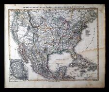
 1897 Map of United States & Mexico Original antique print
-
$67.21 CAD
 1919 antique GEOLOGIC ATLAS folio COLCHESTER MACOMB illinois PLAT BOOK
-
$21.96 CAD
 ANTIQUE 1874 ST CLAIR MONROE RANDOLPH PERRY WASHINGTON COUNTY ILLINOIS HDCLR MAP
-
$17.85 CAD
 1943 Vintage Map - The United States on March 4, 1861 - The Civil War
-
$329.54 CAD
 1848 Stieler Stulpnagel Map United States Mexico Texas Missouri Oregon Territory
-
$30.89 CAD
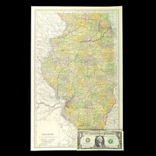
 1910 State of Illinois Antique Color Map 17" x 27"
-
$40.41 CAD
 1939 ORIGINAL VINTAGE LARGE 21 X 15 MAP OF ILLINOIS CHICAGO SPRINGFIELD
-
$30.99 CAD
 1943 ORIGINAL VINTAGE WWII MAP OF ILLINOIS / VERSO IDAHO
-
$63.09 CAD
 1873 Plat Map ~ GROVE LAND Twp., TAZEWELL Co., IL (14x17) Free S&H-#020
-
$63.09 CAD
 1901 Plat Map LA PRAIRIE, NEW LIBERTY, PALOMA, , ADAMS Co., IL (17x29)-#025
-
$37.28 CAD
 1875 Railroad & County Map ~ WAYNE - JEFFERSON - FRANKLYN - WHITE Co., ILLINOIS
-
$41.19 CAD
 1876 Lake Zurich & J. Roberston Residence, Illinois antique map ~ 17.6" x 14.3"
-
$34.33 CAD
 1876 Fulton & McDonough Illinois county map antique ~17.3" x 13.8" hand color
-
$39.13 CAD
 1910 Plat Map Du Page Township Will County Illinois DuPage River Goose Lake
-
$24.03 CAD
 1910 Plat Map City of Joliet Illinois Des Plaines River Railroad & McDonough #16
-
$11.67 CAD
 Rand, McNally & Co Antique 1899 Map Of Illinois 7x6
-
$24.03 CAD
 1910 Plat Map City of Joliet Illinois Will County Broadway Washington Heights #4
-
$88.91 CAD
 1892 Plat Map City of ROCKFORD, IL. ~ RAILROAD YARDS - WATER & POWER (20x30)#08
-
$19.15 CAD
 1874 Chicago Illinois Vintage Old Panoramic City Map - 18x24
-
$32.13 CAD
 Antique 1899 CHICAGO ILLINOIS Map 11"x14" ~ Old Antique Original UNION PARK
-
$274.55 CAD
 Original 1923 Boone County Illinois IL Atlas by Ogle & Co Plat Book
-
$63.09 CAD
 1929 Plat Map ~ SENECA, LA SALLE, Co., ILLINOIS / EAGLE, BRUCE on Reverse
-
$88.91 CAD
 1892 Plat Map City of ROCKFORD, IL, PUBLIC SQUARE - PRAIRIE & EAST STATE St. #18
-
$17.16 CAD
 1914 Plat Map City of Springfield & Environs Illinois Sangamon Coal Co. Casey
-
$43.93 CAD
 1876 Illinois Map McDonough County Macomb Bushnell Colchester Bladinsville Adair
-
$34.55 CAD
 Antique 1899 CHICAGO ILLINOIS Map 11"x14" Old Antique Original HYDE PARK KENWOOD
-
$63.09 CAD
 1874 Plat Map ~ CHESTNUT Twp., KNOX County, ILLINOIS ~ Free S&H
-
$63.09 CAD
 1910 Plat Map ~ EAST PART of EAST PEORIA, TAZEWELL Co., IL (XL17x29)-#022
-
$88.91 CAD
 1892 Plat Map City of ROCKFORD, IL, S WATER - KISHWAUKEE St / E STATE - GROVE St
-
$63.09 CAD
 1874 Plat Map ~ MASCOUTAH, St. CLAIR Co., ILLINOIS (14x17)-#002
-
$23.29 CAD
 Vintage ILLINOIS Map Railroad Wall Art Old Original Electric Rail Lines
-
$20.58 CAD
 General Highway Map, Rock Island County Illinois, Vintage 1955, Rev 1984, Color
-
$54.92 CAD
 1876 Kendall Grundy Cook Illinois county map antique ~ 28.2" x 17.6" hand color
-
$24.03 CAD
 1910 Plat Map City of Joliet Illinois Will County Alder Fuller Haldemann #23
-
$63.09 CAD
 1910 Plat Map ~ SOUTH PART of PEKIN, TAZEWELL Co., Illinois (XL17x29)-#019
-
$26.78 CAD
 1913 Plat Map City of Macomb South Part Mc Donough County Illinois
-
$63.09 CAD
 1894 Plat Map CLINTONIA Twp., CITY of CLINTON, DeWitt Co., ILLINOIS (15x17)-#011
-
$24.03 CAD
 1910 Plat Map City of Joliet Illinois Des Plaines River Patterson's Island #20
-
$43.93 CAD
 1876 Illinois Map Kankakee County Bourbonnais Momence Manteno St. Anne Grant IL
-
$68.59 CAD
 Delinquent List Taxes of Nokomis 1912 Hillsboro Illinois Plat Map Montgomery Cty
-
$17.16 CAD
 1914 Plat Map City of Springfield & Environs Illinois Watch Co. Lincoln Park
-
$260.82 CAD
 Original 1908 SALINE County Illinois IL Atlas by Geo. A. Ogle & Co Plat Book
-
$16.28 CAD
 Vintage ILLINOIS Map Railroad Wall Art Decor Old Original Antique DATED 1914
-
$63.09 CAD
 Old 1876 ILLINOIS City & County Map ~ QUINCY w/ PIKE - PITTSFIELD on Reverse
-
$24.10 CAD
 1927 Antique CHICAGO Illinois Street Map City Map of Chicago Wall Art 1222
-
$33.64 CAD
 1914 Plat Map Curran Township Sangamon County Illinois USGS Soil Map Rare
-
$45.02 CAD
 1875 Railroad & County Map ~ St CLAIR - MONROE - RANDOLF - PERRY Co., ILLINOIS
-
$24.03 CAD
 1910 Plat Map City of Joliet Illinois Riverview Fairmont Stirling Park Lake View
-
$24.03 CAD
 1910 Plat Map City of Joliet Illinois Michigan Central R/R Yard Cassedy's Ad #10
-
$63.09 CAD
 1910 Plat Map ~ MACKINAW Twp., TAZEWELL Co., ILLINOIS (18x17)-#037
-
$67.28 CAD
 1899 Southern Illinois Map ORIGINAL Chicago Springfield Belleville Mattoon
-
$308.88 CAD
 Original 1908 Williamson County Illinois IL Atlas by Ogle & Co Plat Book


