 Antiques (CA)
-
$229.28 CAD

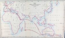 .RARE c1859 ROUTES to AUSTRALIA & NEW ZEALAND ex “RAMBLES in the ANTIPODES”
-
$13.67 CAD
 NZTopo50-AV29 Russell Map, topographic, New Zealand, Bay of Islands, 2009
-
$13.67 CAD
 NZTopo50-BP25 Motueka Map, topographic, New Zealand, Abel Tasman Nat Park, 2009
-
$13.67 CAD
 NZTopo50-CB12 Cardrona Map, topographic, New Zealand, 2009, Wanaka
-
$13.67 CAD
 NZTopo50-CB09 Hollyford Map, topographic, New Zealand, 2009, Routeburn Track
-
$13.67 CAD
 NZTopo50-BJ34 Mount Ruapehu Map, topographic, New Zealand, 2009, Volcano
-
$13.67 CAD
 NZTopo50-BV20 Otira Map, topographic, New Zealand, 2009, Arthur’s Pass
-
$34.16 CAD
 vintage NEW ZEALAND SOUTH ISLAND MOTOR TOURING MAP 1959
-
$13.67 CAD
 NZTopo50-BX15 Fox Glacier Map, topographic, New Zealand, 2009
-
$13.67 CAD
 NZTopo50-BY14 Mount Ward Map, topographic, New Zealand, 2009, Landsborough River
-
$10.93 CAD
 Waitakere Ranges Regional Park Map, topo, New Zealand Aukland Regional Council
-
$164.02 CAD
 1829 Map of Pacific, George Pollard, Whaleship "Essex", Nantucket "Two Brothers"


