
-
$129.89 CAD

 Antique 1771 Map, Derby Shire, England, Plan of Grand Canal Trent to Hersey
-
$116.28 CAD
 Vintage framed Map and illustrations of Derbyshire England colored
-
$68.40 CAD
 1800s Derbyshire England 1895 Antique County Map 10x12.5"
-
$38.29 CAD
 1814 John Cary Road Map Derbyshire Derby Winster Bakewell Ashborn England UK
-
$34.05 CAD
 1898 ANTIQUE MAP OF THE COUNTY OF DERBY DERBYSHIRE CHESTERFIELD / ENGLAND
-
$273.59 CAD
 1845 Europe map by A.K. Johnston ~ 25.8" x 21.2" Antique Pastel Color Huge
-
$27.35 CAD
 c 1850 Thomas Moule Map Derbyshire Derby Winster Bakewell Ashborn England UK
-
$13.67 CAD
 Original 1890 Shire Map DERBY England Chatsworth Sheffield Midland Railway Eyam
-
$170.99 CAD
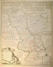
 Derby Shire map, 1725
-
$581.38 CAD
 c1758 COUNTY MAP OF DERBY * E. BOWEN * ORIGINAL*


