
-
$141.65 CAD

 RARE 1894 Colonial British New Guinea Map of Tauwara or Milne Bay
-
$195.10 CAD
 RARE 1892 Colonial British New Guinea Large Map of The Gulf of Papua. #2
-
$195.10 CAD
 RARE 1883 Colonial British New Guinea Map. Areas East of Port Moresby
-
$195.10 CAD
 RARE 1894 Colonial British New Guinea Large Map of Collingwood Bay & Cape Nelson
-
$889.96 CAD
 RARE c1886 11 x Very Large “County” Maps of Victoria Districts by John Sands.
-
$13.51 CAD
 1905 Color Country Maps of New South Wales, Victoria & Tasmania and Australia
-
$534.51 CAD
 RARE c1886 6 x Very Large “County” Maps of QLD Districts by John Sands.
-
$17.12 CAD
 QUEENSLAND 1892 Antique Color Map-Bartholomew-Chambers
-
$135.69 CAD
 Antique Peterman Large Map of Australia Sea Original 1884 Ilyin St. Petersburg
-
$177.28 CAD
 RARE 1899 Colonial Western Part British New Guinea Huge Folding Map.
-
$28.15 CAD
 Antique Map / Print NEW SOUTH WALES / AUSTRALIA / SIDNEY/ 1886
-
$41.11 CAD
 1855 AUSTRALIA COLTON MAP H.C. COUNTIES WEST AUSTRLAIA VICTORIA NEW SOUTH WALES
-
$88.19 CAD
 c1870s Detailed Coloured Map of Victoria County Boundaries + Melbourne Layout.
-
$141.65 CAD
 RARE 1901 Colonial British New Guinea Large Map. Sketch of the Kumusi River.
-
$195.10 CAD
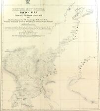 RARE 1896 Colonial British New Guinea Large Map. Mambare River to Gosisi Village
-
$106.90 CAD
 .RARE 1888 VERY LARGE MAP OF NEW GUINEA.
-
$32.90 CAD
 Chef De Tahiti Antique Print Voyages Captain Cook 1780
-
$32.90 CAD
 1898. AUSTRALIA. SOUTHERN PART. NEW SOUTH WALES. VICTORIA. Antique BIG SIZE map
-
$17.80 CAD
 1907 New Guinea & New Caledonia - Antique MAP
-
$13.51 CAD
 1905 Color Country Maps of Queensland Australia and North & South Poles
-
$249.34 CAD
 Double Canoes Pirogues Des Isles Des Amis Cook 1778
-
$17.82 CAD
 1886 Map- Queensland, Australia-Divided Into Districts And Counties
-
$800.88 CAD
 RARE c1886 10 x Very Large “County” Maps of NSW Districts by John Sands.
-
$310.91 CAD
 RARE 1906 Colonial British New Guinea Large Map. The Summit of Mt Albert Edward.
-
$132.74 CAD
 RARE 1899 Colonial Western Part British New Guinea Huge Folding Map. #2
-
$266.37 CAD
 RARE 1906 Colonial British New Guinea Large Map. Tamata to Mt Albert Edward.
-
$150.55 CAD
 RARE c1900 Colonial British New Guinea Large Map of The Morehead River
-
$195.10 CAD
 RARE 1896 Colonial British New Guinea Map. Mambare River & Kumusi Valley
-
$177.28 CAD
 RARE 1914 British New Guinea Large Sketch Map of Fly & Alice Rivers
-
$27.34 CAD
 1903 Color Map of NEW SOUTH WALES, Each then existing county shown
-
$41.05 CAD
 1903 Color County Map of QUEENSLAND AUSTRALIA


