 Antiques (CA)
Africa Maps
Asia Maps
Australia/Oceania Maps
Celestial Maps
Central America/Caribbean Maps
Curiosities Maps
Digital Maps
Europe Maps
Map & Globe Mixed Lots
Map & Globe Reproductions
North America Maps
South America Maps
World & Celestial Globes
World Maps

-
$76.49 CAD

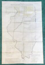 Antique 1837 Historical ILLINOIS Map, Detailed, Shows Very Early Chicago, VG+++
-
$61.51 CAD
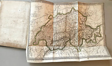
 1750 Hand-Colored Map of Europe by Robert De Vaugondy
-
$293.87 CAD
 Antique Map - 1770 Original Map of North America by Thomas Bowen
-
$341.71 CAD
 Antique 1874 Map of Market Street Lynn Massachusetts as it Appeared in 1820
-
$39.47 CAD
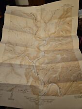
 1873 MIDDLE PARK COLORADO Map Profile Geological ORIGINAL Mt Bross Hot Springs
-
$13.67 CAD
 1866 ANTIQUE CIVIL WAR MAP OF TEXAS AT THE DATE OF ANNEXATION-EXCELLENT DETAIL
-
$39.47 CAD
 1812 Battle Monument Baltimore Engraving 1831 ORIGINAL ENGRAVING Fenner and Sear
-
$560.34 CAD
 1826 MAP of the UNITED STATES Oregon Territory Mexico Texas no Canada America
-
$92.95 CAD
 RARE EARLY 1840 GREEN BAY Wisconsin Map ORIGINAL Lake Michigan HOUGHTON
-
$77.91 CAD
 1831 YALE UNIVERSITY New Haven Connecticut Engraving ORIGINAL Print RARE
-
$27.27 CAD
 1947 Cameron County PA PENNSYLVANIA USGS Topographic Map Vintage Lumber Gibson
-
$66.81 CAD
 1861 FORT SUMTER SOUTH CAROLINA Civil War ORIGINAL ENGRAVED PRINT Fort Moultrie
-
$307.54 CAD
 Rare 1819 BARBIE DU BOCAGE Antique Book w/ 32 Copper Engraved Maps Plans Plates
-
$82.68 CAD
 1852 Antique Military Map British Forts & Positions, 8th Xhosa War South Africa
-
$177.69 CAD
 Original 1898 USGS map Harper's Ferry Martinsburg Charlestown Evitt WV Leesburg
-
$94.31 CAD
 Original Antique 1780 Map of Europe by Bonne
-
$121.70 CAD
 1756 d’ Anville map of the coast of Peru by Bellin, including Lima
-
$27.27 CAD
 1950 Emporium Quadrangle PA Cameron Potter CO. USGS Topographic Map Vintage Rare
-
$403.22 CAD
 = JAN JANSSON (1588-1664) - c. 1640 Tinted Map of WEST AFRICA GUINEA
-
$1076.39 CAD
 Antique "Map of the British and French Settlements in North America" 1755
-
$155.67 CAD
 1758 Map, “Rade et Ville de la Vera-Cruz, vera Cruz, Mexico, by Schley
-
$35.47 CAD
 1935 Vintage Antique MT. WASHINGTON NH New Hampshire USGS Topographic Map
-
$34.16 CAD
 1937 Hartwick Laurens Edmeston New York Antique USGS Topographic Map Vintage
-
$273.37 CAD
 2 America Island Maps by Jean Baptist Anville Circa 1730 Hispaniola Mexican Gulf
-
$24.60 CAD
 Vintage Millsboro, Del., US Army Corps of Engineers, Tactical Map, 1/62500, 1917
-
$205.03 CAD
 1787 Rigobert Bonne Mappemonde Occidental Western Hemisphere Antique Map
-
$40.94 CAD
 1953 Vintage Wayne NY Waneta & Lamoka Lake USGS Topographic Map Lakehouse Decor
-
$40.99 CAD
 1919 USGS Topographic Map MONTPELIER VERMONT ~15 Minute Quadrangle Topo green
-
$263.12 CAD
 1719 H. Chatelain Large Antique Print City Views Algiers, Jijel, Tripoli & Tunis
-
$635.65 CAD
 Antique Map Of The Malabar Coast By Baldaeus (1744) Canara Decan Old Collectible
-
$61.26 CAD
 1913 Antique TOPOGRAPHY map of San Francisco & Surrounding Area Original Maps
-
$34.16 CAD
 1944 St Lawrence County Brier Hill New York Antique USGS Topographic Map Vintage
-
$12.30 CAD
 Newsweek Map of the Month August 1966 "The Legacy of Crisis" 35" x 44"
-
$88.85 CAD
 Map of Hindoostan (India) by Aaron Arrowsmith Sidney Hall 1817 Handcolored
-
$34.16 CAD
 1928 Hobart NY New York Schoharie/Delaware County USGS Topographic Map Vintage
-
$66.81 CAD
 1831 Ruins of Fort Ticonderoga New York Engraving ORIGINAL Fenner and Sears
-
$20.49 CAD
 Antique 19th Century French Swiss Map France Switzerland Prussia Europe 7" x 5¼"
-
$170.84 CAD
 1850 Guysborough Harbour Nova Scotia Antique Sea Coastal Map NS Canada (1859)
-
$21.81 CAD
 Antique 1837 SOUTH WESTERN DISTRICT LOUISIANA MAP, Sabine & Red Rivers, Color
-
$47.84 CAD
 Paris Als Waffenplatz 1851 Antique Map of Environs of Paris by G. Heck
-
$24.60 CAD
 Vintage Boston, Mass., USGS Topographic Map, 1/62,500, 1903
-
$129.85 CAD
 AMERIQUE SEPTENTRIONALE, MAP, Printed By Migeon, (1874) 14 3/4 x 11"
-
$34.10 CAD
 1898 Watkins Glen NY Seneca Lake New York USGS Topographic Map Vintage Schuyler
-
$34.16 CAD
 1939 Tully Onondaga County New York Antique USGS Topographic Map Vintage
-
$68.34 CAD
 1824 Antique Map; Scotland by Anthony Finley
-
$129.85 CAD
 Map "Cartes Particulieres des Isles de France, de Bourbon et de Rodrigue" 1780
-
$34.16 CAD
 1943 DANNEMORA PERU NY New York Clinton County USGS Topographic Map Vintage
-
$98.41 CAD
 RUSSIAN AMERICA ALASKA UNITED STATES CANADA 1846 MALTE-BRUN UNUSUAL ANTIQUE MAP
-
$34.16 CAD
 Vintage 1925 Walton NY Delaware County New York Antique USGS Topographic Map
-
$170.84 CAD
 1857 Beaver Harbour Nova Scotia Antique Sea Coastal Map Atlantic Canada (1859)
-
$34.16 CAD
 1942 Moravia NY Cayuga & Tompkins County New York USGS Topographic Map Vintage
-
$213.68 CAD
 1763 Map of Indonesia, Semarang, Kartasoera, Soerabaya by Schley
-
$40.99 CAD
 1957 USGS Topographic Map LONDONDERRY VT ~15 Minute Quadrangle Topo green
-
$539.91 CAD
 1706 Original Daniel de la Feuille map of Italy and Cities Very Scarce Map
-
$27.34 CAD
 1833 Map of JUDEA in the Time of Christ
-
$27.27 CAD
 1966 Vintage Oswegatchie NY St. Lawrence County USGS Topographic Map Adirondacks
-
$21.93 CAD
 Ballinasloe Roscommon antique road map Ireland c1782 Taylor & Skinner 235/236
-
$191.36 CAD
 USGS TOPOGRAPHIC MAP - GRANVILLE, MASSACHUSETTS / CONNECTICUT
-
$20.49 CAD
 Antique 19th Century Hand Colored African Bookplate Print Map of Africa 1857
-
$54.67 CAD
 OCEANSIDE, CARLSBAD to ENCINITAS, Calif. 1901 Edition reprint 1925 USGS Topo Map
-
$205.03 CAD
 Generalis Lotharingae Ducatus Tabula By Nicolaum Visscher Amst
-
$1366.85 CAD
 Engraving RHEINFELDEN, 1737. , Andreas and Joseph Schmuzer , Austria , Habsburg
-
$27.32 CAD
 DUTCHMAN BUTTE OREGON ORIGINAL 1950 USGS MAP 17X21 EXCELLENT CONDITION
-
$40.99 CAD
 Original 1841 FOX HUNTING Map "Meets of the Petchley Hounds" Northampton England
-
$47.84 CAD
 Chesapeake Bay 1904 Edition, (Reprinted 1913) Original Vintage USGS Topo Map
-
$66.98 CAD
 1863 Johnson's Map of Maryland and Delaware District of Columbia 14 x 18"
-
$375.88 CAD
 ORIG. NAUTICAL CHART - COASTS OF ENGLAND, FLANDERS & HOLLAND -MOUNT & PAGE -1750
-
$102.51 CAD
 Map of Orkney Shetland Scilly Channel Islands Arrowsmith Hall 1817 Handcolored
-
$99.99 CAD
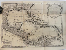
 BRUÉ Map of Caribbean Carte des Isles Antilles des Etats Unis de L'Amérique 1860
-
$2732.33 CAD
 Antique Andreas Cellarius Celestial Ptolemaic World Map Zodiac 18th Century
-
$47.83 CAD
 1954 USGS Topographic Map BRATTLEBORO VERMONT ~15 Minute Quadrangle Topo Green
-
$40.94 CAD
 1953 Vintage Campbell Savona NY Steuben County USGS Topographic Map Antique
-
$34.16 CAD
 1932 Unadilla Sidney Norwich New York Antique USGS Topographic Map Vintage
-
$205.03 CAD
 USGS TOPOGRAPHIC MAP - OYSTER BAY, NEW YORK/CONNECTICUT
-
$21.93 CAD
 Antrim Down antique road map C1782 Northern Ireland Taylor & Skinner map 281/282
-
$259.69 CAD
 Original 1855 Colton's Map of Alabama Taken from Atlas
-
$66.98 CAD
 1863 Johnson's PALESTINE Antique Map Hand Colored 14 x 18"
-
$61.04 CAD
 1872 Map of KENTUCKY & TENNESSEE, Hand Colored
-
$123.02 CAD
 USGS TOPOGRAPHIC MAP - CANAJOHARIE, NEW YORK
-
$42.09 CAD
 1835 Walker Antique Map Scarborough Whitby New Malton North Allerton, Yorkshire
-
$54.67 CAD
 Malibu, Pt. Dume 1921 Edition Original reprinted 1942, Vintage USGS Topo Map
-
$358.29 CAD
 1780 Basel, Bale, Basel, Switzerland, Large copper engraving of the City
-
$40.94 CAD
 1950 Mountour Falls New York Schuyler CO USGS Topographic Map Vintage Antique
-
$27.27 CAD
 1953 Beaver Dams NY Schuyler Steuben County USGS Topographic Map Antique Vintage
-
$33.49 CAD
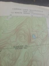 1970 Caroga Lake NY Fulton County New York USGS Topographic Map Antique Vintage
-
$34.16 CAD
 1939 Lake Pleasant Hamilton County NY New York USGS Topographic Map Vintage
-
$191.36 CAD
 original 1906 USGS map Norwalk, Noroton, Darien, NY, Sangatuck, Southport, CT
-
$32.80 CAD
 Northern Egypt Russian Map 1844
-
$27.34 CAD
 Map of Nancy, France circa 1634 FREEPOST
-
$191.36 CAD
 USGS TOPOGRAPHIC MAP - BELCHERTOWN, MASSACHUSETTS
-
$40.99 CAD
 1957 USGS Topographic Map BARRE VT ~15 Minute Quadrangle Topo green
-
$20.72 CAD
 Original Antique 1837 ST. HELENA, LOUISIANA DISTRICT MAP, Very Scarce
-
$40.94 CAD
 1945 Sratford NY Fulton County New York USGS Topographic Map Vintage Antique
-
$1216.50 CAD
 GAIHOZU Org.ACTUAL MAP Confiscated By US From Jap. imp. Army. Pre WWII RARE!!!!
-
$43.52 CAD
 1838 MAP - ITALY Piedmont France Savoy Land of Neff 13.5 x 16.6" 34 x 42 cm
-
$43.58 CAD
 IRELAND Southern Part - c. 1835 Original Map 11 x 16"
-
$205.03 CAD
 USGS TOPOGRAPHIC MAP - WORCESTER, MASSACHUSETTS
-
$40.94 CAD
 1953 Vintage Paradox Lake Schroon NY Essex County USGS Topographic Map Antique
-
$21.81 CAD
 Original Antique 1837 DISTRICT NORTH OF THE RED RIVER LOUISIANA Map, Very Scarce
-
$21.81 CAD
 Antique 1837 SOUTH EASTERN DISTRICT LOUISIANA MAP, Mississippi River, Bayou’s


