 Antiques (CA)
-
$40.77 CAD

 1898 Map of the State of CONNECTICUT Hand Colored Lithograph 10.75 x 7.25
-
$93.26 CAD
 Wallingford Connecticut Yalesville Pond Hill 1868 F.W. Beers detailed town plan
-
$93.26 CAD
 Guilford Connecticut Mulberry Pt. c.1900-10 Eldridge nautical chart antique map
-
$89.14 CAD
 Connecticut Hartford County Map Bristol Township 1869
-
$92.56 CAD
 1846 RARE ORIGINAL MAP TEXAS REPUBLIC UNITED STATES NEW YORK FLORIDA MICHIGAN
-
$115.89 CAD
 1890's Groton Connecticut Groton Long Point Land Company Lot Development Map
-
$18.51 CAD
 Antique Colorful 1885 Map Of Connecticut & Rhode Island 10x7 Inches
-
$38.39 CAD
 1881 Rand McNally Railroad Map Connecticut Hartford New Haven London Mystic CT
-
$19.13 CAD
 1770s Early Map of Connecticut, New Jersey, New York & Long Island - 16x20
-
$33.52 CAD
 Vintage 1901 CONNECTICUT Map 14"x11" Old Antique Original HARTFORD NEW HAVEN CT
-
$143.99 CAD
 Antique Colonial NY Map New York Province North America Land Grants Pease 1849
-
$377.15 CAD
 1867 Town of Darien Connecticut antique map ~ rare ~ 17" x 13.7" hand color
-
$20.97 CAD
 Appalachian Trail: New Jersey, New York, Connecticut, Massachusetts
-
$102.86 CAD
 Hamden Mount Carmel Centreville Connecticut 1868 F.W. Beers town & city plan
-
$116.57 CAD
 New England Maine New Hampshire Vermont Mass. Connecticut 1873 William map
-
$185.15 CAD
 Bridgeport Connecticut 1901 Eldridge detailed coastal nautical survey
-
$44.38 CAD
 Vintage 1900 CONNECTICUT Map 14"x11" Old Antique Original HARTFORD NEW HAVEN CT
-
$23.26 CAD
 1920s Vintage CONNECTICUT Railroad Map Antique Map of Connecticut Wall Art Decor
-
$26.91 CAD
 1897 ANTIQUE DATED MAP OF CONNECTICUT / RHODE ISLAND
-
$29.21 CAD
 1891 CONNECTICUT MAP ANTIQUE FULL COLOR RAILROADS MOUNTAINS LONG ISLAND SOUND
-
$80.92 CAD
 Historic Map Groton Conn 1655-1799 Town Owner Names Genealogy Date Unknown
-
$71.32 CAD
 1830 Nathan Hale Map Connecticut Hartford New Haven London Norwalk Greenwich CT
-
$122.05 CAD
 Antique New England Map New Belgium Original 1849 Pease Litho of Lucini 1634 Map
-
$13.65 CAD
 Antique Map 1890 Massachusetts Rhode Island Connecticut or Vermont New Hampshire
-
$24.62 CAD
 Kent Conn. 1955 Original Vintage USGS Topo Map 27x22 inches
-
$12.69 CAD
 Rand, McNally & Co Antique 1904 Map Of Connecticut & Rhode Island 7x6
-
$27.42 CAD
 ANTIQUE 1893 BRIDGEPORT STRATFORD CONNECTICUT HANDCOLORED MAP RAILROAD DETAILED
-
$48.33 CAD
 Vintage 1900 CONNECTICUT Map 14"x11" ~ Old Antique Original BRIDGEPORT NEW HAVEN
-
$171.43 CAD
 Original Antique 1869 Map of the of Mystic CT Historical Maritime town Wall Map
-
$102.86 CAD
 Connecticut Hartford County Map Burlington Township 1869 J8#22
-
$308.58 CAD
 Rhode Island & Connecticut states 1802 scarce Harris hand colored map
-
$68.50 CAD
 1860 Civil War Era Mitchell Map:NY,CT,MA,RI,NH,VT-New York City & Boston Harbors
-
$24.69 CAD
 Massachusetts, Connecticut & Rhode Island - Original 1882 Map by Phillips & Hunt
-
$34.27 CAD
 1880 Antique Atlas Map / NEW ENGLAND
-
$34.29 CAD
 1869 Baker & Tilden Bristol CT Hartford County Atlas Map
-
$35.66 CAD
 Vintage Nautical Map LONG ISLAND SOUND Eastern Part, Milford to New London, CT
-
$75.43 CAD
 1867 Town of Huntington Connecticut antique map rare ~ 17.3" x 13.8" hand color
-
$68.56 CAD
 1846 RARE ORIGINAL MAP CANADA GREENLAND ONTARIO QUEBEC NOUVELLE GALLE MAINE USA
-
$205.72 CAD
 Port Chester NY Greenwich Connecticut 1901 Eldridge detailed coastal survey
-
$240.00 CAD
 1870 Antique Map ~ CONNECTICUT - WEST HARTFORD
-
$24.18 CAD
 Antique 1862 Lincoln-was-president color map Mass. Conn. R.I. Mitchell Jr 1860s
-
$23.31 CAD
 Connecticut & Rhode Island - Original 1902 Map by The Century Company, Antique
-
$17.76 CAD
 1911 Antique Rand McNally Map of CONNECTICUT & RHODE ISLAND & State Demographics
-
$77.35 CAD
 1875 Map ~ NEW ENGLAND & THE CANADIAN MARITIMES (15x18)-#016
-
$205.72 CAD
 1867 Town of Fairfield Connecticut antique map ~ rare ~ 17" x 13.8" hand color
-
$27.43 CAD
 1869 Baker & Tilden Map of Hebron CT
-
$24.69 CAD
 Connecticut - Original 1910 Dated Map by Dodd Mead & Company. Antique
-
$16.46 CAD
 USGS topographic map Winsted Conn.
-
$32.90 CAD
 1930 Clason Auto Road Map New England Massachusetts Connecticut Maine Vermont
-
$20.50 CAD
 Connecticut and Rhode Island Antique Color Map 1898 U.S. 12¾" x 17"
-
$82.29 CAD
 essex saybrook deepriver 1874 map F.W. Beers Connecticut New England Vintage Ct
-
$78.17 CAD
 1831 YALE UNIVERSITY New Haven Connecticut Engraving ORIGINAL Print RARE
-
$16.44 CAD
 1884 McNally Map Connecticut Rhode Island Providence New Haven Newport Mystic
-
$10.96 CAD
 L@@K! Vintage 1941 World Atlas Colored Maps of Florida FL & Connecticut CT WWII
-
$24.62 CAD
 Cornwall Conn. 1956 Original Vintage USGS Topo Map 27x21.5 inches
-
$20.57 CAD
 Rare WOODBRIDGE Connecticut CT 1930s MAP & Brochure Wepawaug Estates Vintage
-
$137.13 CAD
 1905-History Of The Fanning Family-vol. 2-Map-Groton & Stonington Connecticut
-
$28.36 CAD
 Old 1931 Pictorial Map ~ CONNECTICUT by P.S. JOHST ~ Free S&H
-
$28.36 CAD
 1897 Century Atlas Map ~ CONNECTICUT - RHODE ISLAND ~(12x18) ~ Free S&H #242
-
$28.58 CAD
 1951 ORIGINAL VINTAGE MAP OF HARTFORD CONNECTICUT DOWNTOWN BUSINESS CENTER
-
$109.72 CAD
 1867 Town of Stamford Connecticut antique map ~ rare ~ 26.6" x 22.5" hand color
-
$28.36 CAD
 1884 County & Township Map ~ CONNECTICUT - HARTFORD ~ Old & Original ~ Free S&H
-
$35.18 CAD
 1930s Antique CONNECTICUT State Map RARE Animated Picture Map BLU 6915
-
$41.14 CAD
 Vintage - NOAA 1993 35th Ed Nautical Map - Approaches to New York 12300 Unfolded
-
$21.94 CAD
 1885 McNally Map Connecticut Rhode Island New Haven Hartford Providence Newport
-
$24.69 CAD
 1890 ORIGINAL ANTIQUE MAP OF CONNECTICUT / BRIDGEPORT /STAMFORD / NEW HAVEN
-
$8.23 CAD
 1856 MITCHELL'S GEOGRAPHY ATLAS MAP-MASSACHUSETTS, RHODE ISLAND, & CONNECTICUT
-
$137.15 CAD
 1847 Williams Map New England Massachusetts Connecticut Rhode Island Boston RR
-
$13.70 CAD
 c 1925 Encyclopedia Britannica Map - Connecticut - Hartford New Haven Bridgeport
-
$28.36 CAD
 1882 (15"x11") R. McNally Atlas Map ~ RHODE ISLAND ~ Free S&H
-
$27.42 CAD
 Canvas Reproduction Vintage Pictorial Map of Connecticut Print Ruth Taylor 1935
-
$22.83 CAD
 1950s Animated Vintage CONNECTICUT State Map Connecticut Picture Map BW 7208
-
$34.27 CAD
 1885 Antique Atlas Map / CONNECTICUT
-
$11.66 CAD
 Antique 1914 World Atlas Map Florida FL & Connecticut CT Conn OLD World War WW!
-
$82.27 CAD
 Vintage 1867 Beers Map -Westport CT actual 1867 page size 14.5 by 17.5
-
$24.07 CAD
 1942 Vintage Connecticut State Map Gallery Wall Decor Map of Connecticut 736
-
$617.15 CAD
 Large rolled Antique Map of Connecticut Long Island National Map Company
-
$41.13 CAD
 1852 Antique Atlas Map / NEW ENGLAND, or, EASTERN STATES
-
$23.38 CAD
 1895 Antique Connecticut State Map Wall Decor Atlas Map of Connecticut 757
-
$27.43 CAD
 1892 Perron map NEW LONDON, CONNECTICUT, #43
-
$32.85 CAD
1777 Map of Connecticut, New York, New Jersey & Long Island - 24x30
-
$102.86 CAD
 1867 Town of Danbury Connecticut antique map ~ rare ~ 16.9" x 13.7" hand color
-
$82.27 CAD
 Vintage 1867 Beers Map -New Canaan CT actual 1867 page size about 14.5 by 17.5
-
$37.23 CAD
 1854 Map LONG ISLAND, CONNECTICUT, MASACHUSETTS, RI ~ Hand Colored (9x11)-#010
-
$68.57 CAD
 1867 Town of Bridgeport Connecticut antique map ~ rare ~ 17" x 13.8" hand color
-
$27.42 CAD
 USGS Topographic Map Vintage Colchester Connecticut Original Printed 1953 19x27
-
$35.70 CAD
 1887 ANTIQUE MAP OF PENNSYLVANIA / VERSO NEW JERSEY CONNECTICUT
-
$272.92 CAD
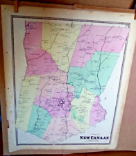
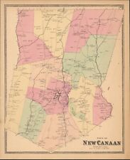 1867 Town of New Canaan Connecticut antique map ~ rare ~ 17" x 13.8" hand color
-
$272.92 CAD
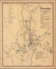 1867 Town of Westport Connecticut antique map ~ rare ~ 17" x 13.8" hand color
-
$89.14 CAD
 1846 Mitchell's Atlas original Connecticut map, 14"x17", original hand color
-
$205.72 CAD
 1867 Town of Norwalk Connecticut antique map ~ rare ~ 17.2" x 13.8" hand color
-
$49.37 CAD
 1879 Map New England USA Victorian Atlas Harpers Geography 1st Edition DWAA9
-
$29.50 CAD
 1890 Map NEW ENGLAND - MAINE, NEWHAMPSHIRE, VERMONT, MASSACHUSETTS -(10x12)#P290
-
$46.63 CAD
 1899 Pine Hill South Britain Connecticut Map ORIGINAL GEOLOGICAL Rattlesnake Hil
-
$6.86 CAD
 antique folding map 1920s Rand McNally Massachusetts Connecticut Rhode Island
-
$17.82 CAD
 Vintage Oakville Fire District Watertown Connecticut Sanitary Sewer Map Plan
-
$3428.63 CAD
 J.H.Young MITCHELL’S NATIONAL MAP OF THE AMERICAN REPUBLIC 1843 VeryGood 36x45
-
$21.93 CAD
 1857 Morse Map - Connecticut Rhode Island Long New York Haven Newport Providence
-
$253.72 CAD
 1829 AFRICA-D.F. Robinson Antique Map - State Of Connecticut 
-
$116.57 CAD
 Southern Middlesex Co. Connecticut Saybrook Clinton Chester 1893 Hurd large map


