 Antiques (CA)
Africa Maps
Asia Maps
Australia/Oceania Maps
Celestial Maps
Central America/Caribbean Maps
Curiosities Maps
Digital Maps
Europe Maps
Map & Globe Mixed Lots
Map & Globe Reproductions
North America Maps
South America Maps
World & Celestial Globes
World Maps

-
$30.24 CAD

 1910s KONIGSBERG VINTAGE MAP Prussia Kaliningrad City Russia ORIGINAL C10-1
-
$68.96 CAD
 Delinquent List Taxes of Nokomis 1912 Hillsboro Illinois Plat Map Montgomery Cty
-
$289.94 CAD
 Map civil war spain - 1874 - Bilbao, very RARE, Guerra civil española séc.XIX
-
$55.06 CAD
 1915 East WIlliamsburg Brooklyn Map Broadway Triangle Flushing Harrison
-
$16.57 CAD
 SAN FRANCISCO & Surrounding Area Berkeley U. 1894 Original plan map USA
-
$3.85 CAD
 1897 Southampton location map. England Original antique print
-
$34.38 CAD
 1890 PARIS Vintage City Map Antique ORIGINAL 11.5 x 9.5 Color C12-6
-
$75.94 CAD
 Blondel Peltier Birds Eye View of Paris Plan du Centre du Paris a Vol Map 1981
-
$27.60 CAD
 AAA Washington DC 1992 Map, Laminated, Place Mat, 14.5" by 20.5" - US Map back
-
$103.55 CAD
 c.1890's/ 1900 PHOTO - JAPAN MAP KYOTO
-
$23.47 CAD
 1896 Map of CONSTANTINOPLE aka Istambul antique printTurkey Greece
-
$34.38 CAD
 1897 SLESIA BOHEMIA MORAVIA Czech Republic Vintage Map ORIG 11.5 x 9.5 C11-9
-
$8.28 CAD
 1896 Map of MOSCOW antique print Russia
-
$34.38 CAD
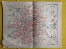
 1896 BERLIN Vintage MAP Germany City Surrounding ORIGINAL 11.5 x 9.5 Color C11-5
-
$52.33 CAD
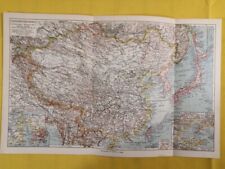 1905 CHINESE EMPIRE Large Vintage Map Geography Korea ORIG. 14.5 x 9.5" - C12-9
-
$53.68 CAD
 1915 BROOKLYN NEW YORK Map South Williamsburg Bedford Stuyvesant Naval Cemetery
-
$34.38 CAD
 1934 London United Kingdom - Vintage Geography Map ORIGINAL 11.5 x 9.5" - C11-9
-
$19.33 CAD
 GMUNDEN Austria - 1929 Last Baedeker Map Issued Before WWII 5.75x6" 14.5x15.5 cm
-
$169.13 CAD
 Antique Map of Paris Lutetia Vulgo Anno 1575 Reprinted in Late 1800s
-
$30.24 CAD
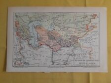 1904 RUSSIAN CONQUEST Central Asia Vintage Geographical Map ORIGINAL C11-6
-
$4.14 CAD
 1897 Map of Plan of the old and new Syracuse Original antique print Italy Sicily
-
$19.33 CAD
 NEW ORLEANS Original plan map 1894 Louisiana
-
$16.57 CAD
 SPAIN Cartagena City Town Plan - 1913 Baedeker Map 4 x 6" (10 x 15 cm)
-
$45.53 CAD
 1889 Planed Monument Map of Paris, A Travers Les Siecles, Illustrated Edition
-
$34.38 CAD
 1924 PRAGUE Czech Republic Vintage City Map ORIG Color 11.5 x 9.5 C13-3
-
$41.27 CAD
 1844 ORIGINAL MAP - Naples Italy & Lisbon Portrugal City Plans
-
$483.23 CAD
 SHANGHAI Japanese Antique Map International & French Concessions China 1937 b557
-
$897.42 CAD
 SHANGHAI Japanese Antique Map w/Bag 1929 Concessions Panoram Photo China b525
-
$53.68 CAD
 1915 Bushwick Brooklyn Map New York Myrtle Avenue Broadway Bleecker Stockholm
-
$55.06 CAD
 1915 Map BRONX New York City ORIGINAL Crotona Park Morrisania Charlotte Gardens
-
$30.24 CAD
 1895 FORTRESS WARFARE Defense Copenhagen 6 x 9.5" ORIG. Double Sided C13
-
$30.24 CAD
 1895 HALLE SAALE Germany Vintage City Map 8 x 9.5" ORIGINAL C13
-
$13.81 CAD
 Edinburgh Dùn Èideann 1905 Scotland Original Map City plan Great Britain
-
$30.24 CAD
 1890 PRAGUE Vintage Map Czech Republic City Plan ORIGINAL Color C10-2
-
$66.96 CAD
 1800s antique ATLAS MAPS pa LANCASTER DRUMORE EAST EARL TOWNSHIP
-
$7.88 CAD
 1896 MAP of San Francisco. original antique print California US
-
$6.90 CAD
 1896 Map of KOLN antique print GERMANY
-
$16.53 CAD
 Vintage 1980 FORT BELVOIR / INDIAN HEAD Maryland Military Topo Map
-
$82.67 CAD
 1915 Bedford Stuyvesant Brooklyn Map Fulton Broadway Rockaway Lewis
-
$30.24 CAD
 1895 FORTRESS WARFARE Battle Strasbourg Germany 6 x 9.5" ORIG. Double Sided C13
-
$16.57 CAD
 DUBLIN plan 1894 IRELAND ORIGINAL Map Baile Átha Cliath Éire
-
$2416.14 CAD
 MAP AND HISTORY OF PEIPING PEKING CHINA BY FRANK DORN 1936
-
$34.38 CAD
 1897 SLESIA BOHEMIA MORAVIA Czech Republic Vintage Map ORIG 11.5 x 9.5 C12
-
$20.02 CAD
 GREECE & Aegian Sea Steamboat Routes Turkey - 1908 Baedeker Map 6x6.5" 15x17 cm
-
$34.38 CAD
 1900 PARIS Vintage City Map Surroundings ORIGINAL 11.5 x 9.5 Color C11-5
-
$34.38 CAD
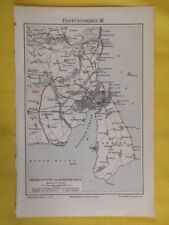
 1897 BRESLAU POLAND Vintage Geographical Map ORIGINAL 11.5 x 9.5 Color C13-3
-
$30.24 CAD
 1905 CHICAGO ILLINOIS Vintage Geographical Map City USA ORIGINAL C11-6
-
$37.28 CAD
 Beirut Original city plan map of Lebanon 1934 بيروت Bayrūt
-
$34.38 CAD
 1890 SLESIA BOHEMIA MORAVIA Czech Republic Vintage Map ORIG 11.5 x 9.5 C12-2
-
$30.24 CAD
 1875 GERMAN EMPIRE Prussia Vintage Geographical Map Russia ORIGINAL C11-8
-
$13.81 CAD
 Cairo القاهرة al-Qāhirah & Pyramids EGYPT Original 19 Century map
-
$34.38 CAD
 1924 PARIS Vintage City Map France Antique ORIGINAL 11.5 x 9.5 Color C13-3
-
$41.42 CAD
 1895 Lewiston / Auburn Maine-- Antique Reproduction
-
$30.24 CAD
 1930 FAROE ISLANDS Vintage Geographical Map Denmark ORIGINAL 11.5 x 9.5"- C12-5
-
$34.52 CAD
 1895 Kraków Cracow Original city plan map Poland 19th Century Krakow
-
$34.38 CAD
 1899 WESTERN PRUSSIA Vintage Geographical Map Russia Empire ORIGINAL C12-2
-
$52.33 CAD
 1896 London United Kingdom - Vintage Large City Map ORIGINAL 14.5 x 9.5" - C12-9
-
$52.33 CAD
 1880 BIRMANIA Burma Myanmar Asia Map Yangon Bagan ORIGINAL 14.5 x 10" - C12-9
-
$6.90 CAD
 1896 Map of PORT OF KIEL. antique print GERMANY
-
$966.45 CAD
 Rare SINGAPORE Original map city street plan SOUTH EAST ASIA MALAYSIA 1914
-
$33.00 CAD
 1899 London United Kingdom - Vintage City Map ORIGINAL 11.5 x 9.5" - C11-9
-
$16.57 CAD
 1905 MAP Baedeker - CZECH REPUBLIC Marienbad Marianske Lazne City Plan
-
$52.33 CAD
 1896 London United Kingdom - Vintage Large City Map ORIGINAL 14.5 x 9.5" - C12-9
-
$30.24 CAD
 1890 BRESLAU Poland Vintage Geographical Map ORIGINAL C12-5
-
$16.57 CAD
 Original SANTIAGO de CHILE CHILE @ Valparaíso SOUTH AMERICA city plan 1900
-
$16.55 CAD
 Washington DC Vintage Color Map Visitor Guide Capsco 1964 17 x 21 3/4 Tourist
-
$345.16 CAD
 c.1890's/ 1900 MAP OF NIKKO TEMPLES COMPLEX
-
$138.06 CAD
 1851 Map of Paris
-
$82.62 CAD
 Vintage 1925 City Map of PORTSMOUTH NH ~ Original Detailed 17 x 22 Scarce
-
$4.14 CAD
 1896 Plan of MESSINA antique print ITALY
-
$13.81 CAD
 MADRID city plan Spain Original Map 1905
-
$20.02 CAD
 AUSTRIA Baden Laxenburg - 1929 Last Baedeker City Map Before WWII 4x6" 10x15 cm
-
$34.38 CAD
 1892 SLESIA Vintage CITY German Empire Breslau ORIGINAL 11.5 x 9.5 Color C10-8
-
$30.24 CAD
 1905 ALEXANDRIA EGYPT Vintage Geographical Map City Africa ORIGINAL C11-6
-
$30.24 CAD
 1905 ATHENS Vintage Map Greece City Plan ORIGINAL Color C10-2
-
$20.02 CAD
 PASSAU Austria - 1929 Last Baedeker City Map Issued Before WWII 4x6" 10x15 cm
-
$34.38 CAD
 1902 EGYPT Vintage Geographical Map City German Sudan Africa ORIGINAL C12-2
-
$9.66 CAD
 1896 Map PLAN OF VIENNA. antique print Austria
-
$690.32 CAD
 SHANGHAI & CHINA Japanese Antique Map 1932 Incident Concessions View Photo b559
-
$35.76 CAD
 1924 HISTORY OF EUROPE Vintage Geographical Map Color ORIGINAL C12-3
-
$44.02 CAD
 CONSTANTINOPLE City Plan Turkey 9 x 11" (23 x 8cm) - 1934 German Map
-
$23.47 CAD
 WASHINGTON 1905 JANUARY dated Original plan map United States
-
$19.33 CAD
 GREECE Mistra New Sparta & Environs - 1908 Baedeker Map 4x6" (10x15cm)
-
$158.77 CAD
 1894 Lithography SINGAPORE Original map city street plan ASIA
-
$34.52 CAD
 SAN FRANCISCO 1912 September dated ORIGINAL plan map USA California
-
$5.52 CAD
 1896 Map of POTSDAM antique print GERMANY
-
$48.32 CAD
 Paris Als Waffenplatz 1851 Antique Map of Environs of Paris by G. Heck
-
$30.24 CAD
 1905 CHICAGO ILLINOIS Vintage Geographical Map City USA ORIGINAL C13-3
-
$12.43 CAD
 1896 Map of Königsberg Królewiec Kaliningrad antique print Russia PRUSIIA
-
$30.24 CAD
 1905 MARSHALL ISLANDS Vintage Geographical Map Asia 8 x 9.5" ORIGINAL C13
-
$23.47 CAD
 PALMA Spain Original Map 1929 Palma de Mallorca
-
$30.24 CAD
 1897 NEW ZEALAND Vintage Geographical Map Oceania Asia 6 x 9.5" ORIGINAL C13
-
$34.38 CAD
 1900 London England City Vintage Geography Map ORIGINAL 11.5 x 9.5" C12-9
-
$30.24 CAD
 1896 HEIDELBERG Germany Cartography Vintage Geographical Map ORIGINAL C11-6
-
$41.41 CAD
 Good Early map of Rome, New York dated 1802, from 1850 Book
-
$34.45 CAD
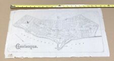 Antique original map town Chautauqua New York Matthews-Northrup & Co., Buffalo
-
$62.13 CAD
 1915 Bedford Stuyvesant Brooklyn Map New York Flushing Broadway Lafayette
-
$30.24 CAD
 1905 ATHENS Vintage Map Greece City Plan ORIGINAL Color C12-5
-
$33.00 CAD
 1877 London United Kingdom - Vintage City Map ORIGINAL 11.5 x 9.5" - C12-9
-
$30.24 CAD
 1895 AACHEN Germany Vintage City Map 8 x 9.5" ORIGINAL C13


