 Antiques (CA)
-
$65.83 CAD

 1897 MASSACHUSETTS Map East Bristol ORIGINAL Boston Lynn Worcester Gloucester
-
$93.09 CAD
 OLD 1880 Map UNITED STATES ORIGINAL Buckwheat Cities FARMING Indian Territory
-
$67.04 CAD
 1880 United States Map Barley Farming Agriculture Wisconsin California Oregon
-
$53.32 CAD
 1880 UNITED STATES Map ORIGINAL Farming Oats Agricultural Texas Colorado Florida
-
$67.04 CAD
 1900 United States Map ORIGINAL Oat Farming Production Agriculture Texas Iowa
-
$92.56 CAD
 1846 RARE ORIGINAL MAP TEXAS REPUBLIC UNITED STATES NEW YORK FLORIDA MICHIGAN
-
$28.58 CAD
 Vintage 1896 INDIAN NATIONS Map 14"x11" Old Antique Original TRIBES
-
$34.27 CAD
 1883 Antique Atlas Map / RHODE ISLAND
-
$27.42 CAD
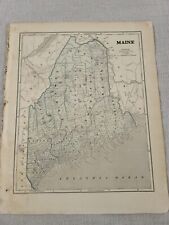
 1883 Antique Map / STATE OF MAINE / 14.5x20.5 inches
-
$116.57 CAD
 1836 State Maps (8) Engraved by George Boynton Pub. S. G. Goodrich - Book Plates
-
$119.99 CAD
 1891 Massachusetts Topographical Map Counties North of Rhode Island & CT
-
$29.57 CAD
 Vintage 1894 INDIAN NATIONS Map 14"x11" ~ Old Antique Original TRIBES
-
$42.80 CAD
 1927 VINTAGE MAP OF NE USA GREAT LAKES MICHIGAN ERIE ONTARIO NEW YORK / CANADA
-
$185.15 CAD
 1842 Large Map of Maine. From Morse's North American Atlas. Color
-
$240.00 CAD
 1870 Antique Map ~ CONNECTICUT - WEST HARTFORD
-
$67.89 CAD
 Scarce©1839 Mitchell Map New England(ME,VT,NH,MA,CT,RI) ME's Disputed Boundaries
-
$21.93 CAD
 1885 McNally Map - Nova Scotia New Brunswick Halifax Frederickton Fundy - Canada
-
$71.32 CAD
 1830 Nathan Hale Map Connecticut Hartford New Haven London Norwalk Greenwich CT
-
$38.39 CAD
 1830 Nathan Hale Map New Hampshire Concord Portsmouth Dartmouth White Mountains
-
$29.57 CAD
 Vintage 1896 INDIAN NATIONS Map 14"x11" ~ Old Antique Original MOHEGAN TRIBE
-
$29.57 CAD
 Vintage 1895 INDIAN NATIONS Map 14"x11" ~ Old Antique Original TRIBES
-
$38.39 CAD
 1881 Rand McNally Railroad Map Rhode Island Providence Newport Block Island RI
-
$38.39 CAD
 1830 Nathan Hale Map Rhode Island Providence Newport Greenwich Watch Hill Canal
-
$34.27 CAD
 1880 Antique Atlas Map / NEW ENGLAND
-
$960.02 CAD
 A New Map of Upper and Lower Canada by: John Cary, 1807
-
$54.84 CAD
 1855 Johnston Military Map War of 1812 United States Canada Great Lakes Niagara
-
$30.86 CAD
 1931 Geological Survey Topographic Map NH Littleton Lyman & Connecticut River
-
$27.42 CAD
 1883 Antique Map / STATE OF RHODE ISLAND / 10.5x14.5 inches
-
$198.86 CAD
 Vintage 1901 UNITED STATES of AMERICA Map 22x14 Antique Map In 30x24 Frame
-
$410.74 CAD
 1860 U.S.C.S.Nautical Chart MONOMOY NANTUCKET SHOAL BLOCK ISLAND-1874 CORRECTION
-
$274.29 CAD
 1843 Stulpnagel Map North South America United States Texas California Brazil SA
-
$60.48 CAD
 1916 Map BURRILVILLE Rhode Island QUAD Geological Survey 16x20" Glocester, etc
-
$119.99 CAD
 1891 Massachusetts Topographical Map of Counties Bordering NH, near the Ocean
-
$29.57 CAD
 Vintage 1892 INDIAN NATIONS Map 14"x11" ~ Old Antique Original TRIBES
-
$30.86 CAD
 1913 Geological Survey Topographic Map NH Plainfield Hanover White River Juc VT
-
$119.99 CAD
 1891 Massachusetts Atlas Map / CITY OF NEW BEDFORD, MA
-
$143.99 CAD
 1891 Massachusetts Topo Map North of Vinyard & Nantucket Sounds,Part of Cape Cod
-
$68.56 CAD
 1846 RARE ORIGINAL MAP CANADA GREENLAND ONTARIO QUEBEC NOUVELLE GALLE MAINE USA
-
$49.37 CAD
 1951 Map TORRINGTON CONN. QUAD Geological Survey 17x21" New Hartford Harwinton
-
$329.15 CAD
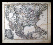 1848 Stieler Stulpnagel Map United States Mexico Texas Missouri Oregon Territory
-
$21.93 CAD
 1937 Rand McNally Map Massachusetts Boston Plymouth Salem Cape Cod Barnstable MA
-
$10.90 CAD
 Pepperell Mass. N.H. New Hampshire 17" X 21" Vintage USGS Topographic Topo Map
-
$49.32 CAD
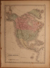
 Vintage 1901 NORTH AMERICA Map 14"x22"~ Old Antique Original CANADA MEXICO USA
-
$48.33 CAD
 Vintage 1901 NORTH AMERICA Map 14"x22" Old Antique Original CANADA MEXICO USA
-
$38.39 CAD
 1881 Rand McNally Railroad Map Massachusetts Boston Cape Cod Salem Springfield
-
$135.77 CAD
 1904 USGS topo map Easthampton Quadrangle Napeague Beach
-
$119.99 CAD
 1891 Massachusetts Map / Boston Metro, Cambridge, Belmont, Watertown, Waltham
-
$24.69 CAD
 1911 McNally Index Map - Rhode Island Providence Bristol Woonsocket Kingston RI
-
$143.99 CAD
 1891 Massachusetts Topographical Map of Counties on Cape Cod, North of Nantucket
-
$10.22 CAD
 Kennebunk ME Maine 16.5" X 20" Vintage 1944 USGS Topographic Topo Map
-
$28.36 CAD
 Vintage 1907 Railroad & County Map ~ RHODE ISLAND ~ Old Authentic ~ Free S&H
-
$192.00 CAD
 1809 Delalain Map North America United States Louisiana California Napoleon Era
-
$153.05 CAD
 1844 Hand Drawn Survey Alexander Wadsworth, Dana & Ellery Streets CAMBRIDGE MA
-
$40.36 CAD
 1921 ANTIQUE MAP OF FLORIDA GEORGIA SOUTH CAROLINA NEW YORK MAINE VIRGINIA
-
$41.13 CAD
 1890 Topo Map of BLACKSTONE QUADRANGLE, MA, ALONG RHODE ISLAND BORDER
-
$61.72 CAD
 1878 United States map 22.8" x 15.1" nice color - Island of New Foundland inset
-
$28.36 CAD
 1884 County & Township Map ~ CONNECTICUT - HARTFORD ~ Old & Original ~ Free S&H
-
$21.94 CAD
 1885 McNally Map Connecticut Rhode Island New Haven Hartford Providence Newport
-
$13.70 CAD
 1900 McNally Map - Vermont New Hampshire Concord Montpelier Mt. Washington NH VT
-
$30.86 CAD
 Antique 1918 Geological Survey Topographic Map MA Barre New Braintree Brookfield
-
$38.39 CAD
 1858 Delamarche Map North America United States Canada Mexico Alaska West Indies
-
$21.93 CAD
 Original Antique 1870 Map WEST FITCHBURG Rockville + MA Massachusetts BEERS
-
$137.15 CAD
 1847 Williams Map New England Massachusetts Connecticut Rhode Island Boston RR
-
$13.70 CAD
 c 1925 Encyclopedia Britannica Map - Connecticut - Hartford New Haven Bridgeport
-
$45.02 CAD
 1911 ANTIQUE MAP OF NORTHEAST USA NEW YORK MAINE GREAT LAKES / ONTARIO CANADA
-
$48.00 CAD
 1856 Black's North America - Map 17.3" x 12.5" - Antique
-
$119.99 CAD
 1891 Massachusetts Topographical Map of Counties Southeast of Connecticut River
-
$119.99 CAD
 1891 Massachusetts Atlas Map / CITY OF LYNN, MA
-
$9.60 CAD
 What did our National Parks System look like in 1958 ? Original Map US & Canada
-
$61.72 CAD
 1844 U.S.A. Map by Olney "NEW ENGLAND and NEW YORK" States (VT NH ME MA CT RI)
-
$41.13 CAD
 1852 Antique Atlas Map / NEW ENGLAND, or, EASTERN STATES
-
$119.99 CAD
 1891 Massachusetts Atlas Map / CITY OF WOBURN, MA
-
$119.99 CAD
 1891 Massachusetts Atlas Map / CITY OF SALEM, MA
-
$54.84 CAD
 1900 Stuart Map Aroostook County Maine Houlton Presque Isle Caribou Fort Kent ME
-
$43.47 CAD
 1868 ORIGINAL ANTIQUE MAP OF OF EASTERN USA NEW YORK GREAT LAKES FLORIDA GEORGIA
-
$71.30 CAD
 1900 Stuart Map Maine Prouts Neck Scarborough Beach & Greenville Moosehead Lake
-
$685.73 CAD
 1840 North America antique map by Greenleaf - 14.2" x 12" scarce 1st edition
-
$29.50 CAD
 1890 Map NEW ENGLAND - MAINE, NEWHAMPSHIRE, VERMONT, MASSACHUSETTS -(10x12)#P290
-
$63.02 CAD
 Old 1870 Plat Map ~ WEST FITCHBURG, WORCESTER Co., MASSACHUSETTS
-
$81.60 CAD
 1864 Map State of New York County Map Antique Original Hand Colored Mitchell
-
$108.62 CAD
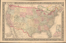
 1926 Clason Auto Road Map & Distance Chart United States Transcontinental Trails
-
$21.93 CAD
 1857 Morse Map - Connecticut Rhode Island Long New York Haven Newport Providence
-
$13.70 CAD
 1958 McNally Map - Rhode Island - Providence Newport Narrangansett Bay Warwick
-
$19.20 CAD
 1937 Rand McNally Map Maine Augusta Bangor Portland Caribou Ellsworth Mt. Desert
-
$21.94 CAD
 1911 McNally Index Map - Connecticut New Haven Hartford Waterbury New London CT
-
$10.90 CAD
 Haverhill Mass. N.H. 16.5" X 20" Vintage 1932 USGS Topographic Topo Map
-
$119.99 CAD
 1891 Massachusetts Atlas Map / CITY OF LAWRENCE, MASSACHUSETTS
-
$54.84 CAD
 1830 Nathan Hale Map - Massachusetts - Boston Plymouth Cape Cod Salem Worcester
-
$20.57 CAD
 Antique 1889 Map CT MA MA NH RI by George F Cram Unrivaled Family Atlas 13x10
-
$65.83 CAD
 1900 Stuart Map Maine Waldo County Belfast Searsport Penobscot Bay Islesboro ME
-
$24.37 CAD
 1895 Map of Main Portion Of St. Paul & Minneapolis By Rand McNally & Co.
-
$119.99 CAD
 1891 Massachusetts Topographical Map of Counties East of New York State
-
$41.14 CAD
 A Map of The Travels of George Washington National Geographic 1931
-
$21.94 CAD
 1885 McNally Map - Vermont New Hampshire Concord Montpelier Mt. Washington
-
$102.86 CAD
 1860 United States & Territories by Mitchell beautiful antique map 22.7" x 14.7"
-
$16.46 CAD
 Large 1882 Antique Map: Coast Survey of Eastern USA 1
-
$63.14 CAD
 Vintage 1900 NORTH AMERICA Map 14"x22" ~ Old Antique Original CANADA MEXICO USA
-
$32.90 CAD
 1937 US Air Commerce Map American Operated Airline Route Distances United States
-
$61.72 CAD
 1876 maps Canton, Massachusetts, from Norfolk County Atlas, with family names!
-
$61.72 CAD
 1876 map town of Weymouth, North Weymouth, Franklin village, w/family names


