 Antiques (CA)
Africa Maps
Asia Maps
Australia/Oceania Maps
Celestial Maps
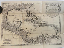
Central America/Caribbean Maps
Curiosities Maps
Digital Maps
Europe Maps
Map & Globe Mixed Lots
Map & Globe Reproductions
North America Maps
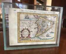
South America Maps
World & Celestial Globes
World Maps

-
$67.24 CAD

 1843 Asia Map Physical ORIGINAL China Mongolia India Persia Iran Arabia Siberia
-
$275.11 CAD
 1867 Kansas Colorado Montana & Dacota Hand Colored Map 13 x 15 Mitchell Antique
-
$295.74 CAD
 Antique Map - 1770 Original Map of North America by Thomas Bowen
-
$529.59 CAD
 1744 Georg Mattaus Seutter Antique Map of Africa
-
$48.14 CAD
 1873 GUYOT'S PHYSICAL GEOGRAPHY World Maps Atlas History
-
$61.90 CAD
 1750 Hand-Colored Map of Europe by Robert De Vaugondy
-
$30.26 CAD
 Old 1849 Authentic Mitchell Atlas Map ~ HEMISPHERES of the WORLD ~ Free S&H
-
$103.17 CAD
 1812 Lapie Map of Great Britian Scotland and Ireland
-
$22.00 CAD
 1882 McNally 12 page Map Drawing Section - Draw World & United States to Scale
-
$563.91 CAD
 1826 MAP of the UNITED STATES Oregon Territory Mexico Texas no Canada America
-
$171.94 CAD
 1877 F. V. Hayden Parts of Western Wyoming and Southeastern Idaho Map
-
$34.39 CAD
 1876 Turkey in Europe & Greece antique map ~ 19.6" x 14.2" hand colored
-
$206.33 CAD
 1787 Rigobert Bonne Mappemonde Occidental Western Hemisphere Antique Map
-
$185.70 CAD
 Original 1830 North America, United States Territorial Map
-
$378.28 CAD
 1780 Bonne Map of Southwest America and New Spain
-
$110.03 CAD
 1879 Map Asia Desert Arctic Peninsula Belt Victorian Geography 1st Edition DWAA9
-
$110.03 CAD
 1879 North Central States Group US Victorian Atlas Geography 1st Edition DWAA9
-
$13.00 CAD
 Preu MICHELIN Map 140 Carte Touristique de la PROVENCE 1950's France
-
$96.29 CAD
 Eighteenth Century Hand-Col. Map of London & Environs, 1787 - PRICE REDUCED
-
$273.73 CAD
 1840 Australia map by Greenleaf ~ 14.2" x 11.9" scarce 1st edition Antique
-
$18.57 CAD
 Map Revolutionary War South Colonies 1871 Victorian Woodcut Print History DWAA12
-
$136.18 CAD
 1878 Colorado Montana Dakota & Wyoming Mitchell antique map 22.9" x 15.1"
-
$378.28 CAD
 1867 Town of Darien Connecticut antique map ~ rare ~ 17" x 13.7" hand color
-
$61.90 CAD
 1862 Johnson's Missouri and Kansas Map Johnson & Ward Antique
-
$240.72 CAD
 1875 Map Yellowstone Montana Captain William Ludlow US Army Corps Engineers
-
$275.11 CAD
 2 America Island Maps by Jean Baptist Anville Circa 1730 Hispaniola Mexican Gulf
-
$41.27 CAD
 1876 Lake Zurich & J. Roberston Residence, Illinois antique map ~ 17.6" x 14.3"
-
$110.03 CAD
 1879 Map West Central States Group Victorian Atlas Geography 1st Edition DWAA9
-
$110.03 CAD
 1879 Map New England USA Victorian Atlas Harpers Geography 1st Edition DWAA9
-
$48.14 CAD
 1899 North Italy Map ORIGINAL Venice Genoa STEAMSHIP ROUTES Provinces RAILWAYS
-
$110.03 CAD
 1879 Map South Central Atlantic US Victorian Harpers Geography 1st Edition DWAA9
-
$110.03 CAD
 1879 Map West Pacific NW & Southwest Group Victorian Geography 1st Edition DWAA9
-
$110.03 CAD
 1879 Map Connecticut United States Victorian Atlas Geography 1st Edition DWAA9
-
$9.53 CAD
 1921 South America Map National Geographic Tattered Wall Map 26x37" 1920's
-
$23.38 CAD
 Original 1903 Physical Map of Africa by Dodd Mead & Company. Antique
-
$9.56 CAD
 Vintage Hammonds 1911 Atlas Map Of Louisiana
-
$110.03 CAD
 1879 Map Massachusetts Boston US Victorian Atlas Geography 1st Edition DWAA9
-
$110.03 CAD
 1879 Map Europe Western And Central Victorian Geography 1st Edition DWAA9
-
$110.03 CAD
 1879 Map Maine United States New England Victorian Geography 1st Edition DWAA9
-
$94.91 CAD
 Original Antique 1780 Map of Europe by Bonne
-
$240.72 CAD
 1840 Maine antique map by Greenleaf ~ 14.25" x 11.9" scarce 1st edition
-
$110.04 CAD
 1867 Town of Stamford Connecticut antique map ~ rare ~ 26.6" x 22.5" hand color
-
$110.03 CAD
 1879 Map Texas & Southern Plains States US Victorian Geography 1st Edition DWAA9
-
$24.76 CAD
 Map War Of 1812 Indian Wars 1871 Victorian Lithograph History Swinton DWAA12
-
$110.03 CAD
 1879 Map Europe Spain France Italy England Victorian Geography 1st Edition DWAA9
-
$110.03 CAD
 1879 Map US Mid Atlantic States Victorian Harpers Geography 1st Edition DWAA9
-
$110.03 CAD
 1879 Map Of South America Brazil Victorian Geography 1st Edition DWAA9
-
$19.95 CAD
 1931 BAEDEKER MAP - Italy GRADO AQUILEIA City Plan + Railroads
-
$68.78 CAD
 1864 Dakota Montana Nebraska Kansas CO by Johnson Ward antique map 17.3" x 13.8"
-
$110.03 CAD
 1879 Map British Isles England Scotland Victorian Geography 1st Edition DWAA9
-
$343.89 CAD
 RARE ANTIQUE MAP -SOUTH AMERICA-HAND COLORED-VELLUM, C 1618
-
$61.90 CAD
 1862 Johnson's New York Map Johnson & Ward Illustrated Family Atlas Antique
-
$49.52 CAD
 Antique Map RUSSIA 1864 Engraved & Hand Colored~From Johnson & Ward Atlas
-
$40.92 CAD
 1860 ORIGINAL MAP - Europe Asia Showing Extent of Alexander the Great Empire
-
$22.00 CAD
 c. 1920 Hammond Washington Map Elevation Railroads Seattle Tacoma Olympia
-
$55.02 CAD
 1876 Kendall Grundy Cook Illinois county map antique ~ 28.2" x 17.6" hand color
-
$262.29 CAD
 1770 J.V. Schley, Batticaloa, Ceylon, panoramic view hand colour view, map
-
$204.96 CAD
 1878 Texas antique map 22.8" x 15.1" nice color - Galveston Indian Territory NM
-
$515.83 CAD
 1862 Johnson California Southwest Territory antique map 26.1" x 18.7" nice color
-
$226.97 CAD
 1867 Town of Newtown Connecticut antique map ~ rare ~ 16.8" x 14.2" hand color
-
$206.33 CAD
 1867 Town of Norwalk Connecticut antique map ~ rare ~ 17.2" x 13.8" hand color
-
$287.05 CAD
 1773 Bellin, map, Hudson Bay, Canada, James BAY, Labrador
-
$116.92 CAD
 Antique French Published Arabia Map, Pierre Du Val, C 1670
-
$16.51 CAD
 1897 BAEDEKER MAP - Germany Hamburg & Environs
-
$14.97 CAD
 1910 Dollar Atlas Vintage Map Pages - West Virginia map on one side
-
$24.76 CAD
 Map Of Original 13 Colonies 1871 Victorian Lithograph History Swinton DWAA12
-
$61.90 CAD
 1878 Georgia Alabama Mitchell antique map 22.7" x 15.1" Atlanta Savannah insets
-
$687.77 CAD
 1840 North America antique map by Greenleaf - 14.2" x 12" scarce 1st edition
-
$13.74 CAD
 1885 Cortambert Map - South America Brazil Argentina Colombia Peru Uruguay Chili
-
$28.93 CAD
 1897 BAEDEKER MAP - WALES between Bangor & Tremadog
-
$275.11 CAD
 1845 Palestine map by A.K. Johnston ~ 25.8" x 21.2" Antique Pastel Color Huge
-
$34.39 CAD
 1876 Bureau & Henry Illinois county map antique ~ 17.3" x 13.8" hand color
-
$30.26 CAD
 Union of South Africa - Western - Large Original 1926 Map by George Philip.
-
$281.00 CAD
 1754 Schley, Bellin, map of Panama, Gulf of Darien, Central America
-
$22.00 CAD
 1911 Stieler Map Russia St. Petersburg Kliew Smolensk Moscow Poland Warsaw Wilna
-
$232.69 CAD
 1780 Bonne - Spain & Portugal - hand coloured engraved map
-
$68.78 CAD
 1867 Town of Bridgeport Connecticut antique map ~ rare ~ 17" x 13.8" hand color
-
$619.00 CAD
 1749 Formosa / Taiwan antique map by Bellin / Schley ~ 18.7" x 11.7" China rare
-
$96.29 CAD
 1820 Ancient Greece antique map by Lavoisne ~ 21.8" x 17.5" hand colored
-
$378.28 CAD
 1867 Town of Greenwich Connecticut antique map ~ rare ~ 17.1" x 13.8" hand color
-
$34.39 CAD
 1876 Woodford & Peoria Illinois county map antique ~ 17.3" x 13.8" hand color
-
$103.10 CAD
 Antique Transportation Map of Japan Circa 1920's Vintage Explorer Japanese Good
-
$22.00 CAD
 1900 Meyers Physical World Map Mountains Rivers Europe Asia America Africa
-
$13.59 CAD
 Morocco 1892 Antique Map R.S. Peale 9th Edition Encyclopedia Britannica
-
$24.76 CAD
 1881 Andrees Map Pacific Ocean Oceania Australia Hawaii Tonga Japan Asia America
-
$343.89 CAD
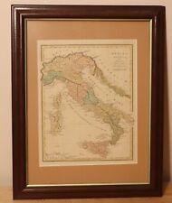 1815 Italy of antiquity by R. Wilkinson - beautiful antique framed map - London
-
$48.14 CAD
 1860 Austrian Empire Italian States & more antique map by Mitchell 15.3" x 12.3"
-
$20.63 CAD
 1901 Tunison Dominion of Canada antique map ~ 14.8" x 11.9" - nice color
-
$130.68 CAD
 1862 Johnson Dakota Nebraska Kansas Colorado antique map 17.4" x14.2" nice color
-
$262.29 CAD
 1770 J.V. Schley, Sri Lanka, Ceylon, Trincomalee, large copper engraving, map
-
$25.68 CAD
 MAP OF FRANCE WINE REGIONS ORIGINAL GENUINE large 1852 GOOD CONDITION TO FRAME
-
$165.07 CAD
 1892 Death Valley Expedition Map, Biological Survey, Tulare Lake, Las Vegas, etc
-
$103.17 CAD
 1867 Town of Danbury Connecticut antique map ~ rare ~ 16.9" x 13.7" hand color
-
$41.27 CAD
 1867 Town of Lewisboro New York antique map ~ rare ~ 17.1" x 13.9" hand color
-
$481.44 CAD
 1864 Johnson's California with territories of Utah, Nevada, Colorado, New Mexico
-
$27.50 CAD
 1911 Stieler Map Italy Croatia Adriatic Sea Fiume Triest Pola Ancona Rome Plan
-
$103.17 CAD
 1865 Mexico, Texas, Central America & more by Mitchell - beautiful antique map
-
$116.92 CAD
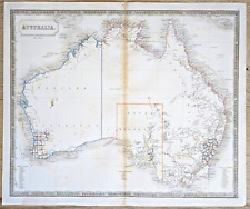 Australia Antique Map circa 1850 by Sidney Hall Engraved Outline Color
-
$67.40 CAD
 1897 RUSSIA Map Moscow ORIGINAL Poland Finland Ukraine Odessa RAILROADS ANTIQUE
-
$48.14 CAD
 World War I WWI Great War Map of Girsovo Island Area Bulgaria 1910"s FREE POSTAG


