
-
$1087.52 CAD

 1891 antique full Set of 14 USA lighthouse district Maps charts nautical
-
$54.72 CAD
 BIG 1922 antique map Alaska US C&G Survey Condition of Hydrography Gold Oil
-
$403.55 CAD
 = JAN JANSSON (1588-1664) - c. 1640 Tinted Map of WEST AFRICA GUINEA
-
$170.98 CAD
 1850 Guysborough Harbour Nova Scotia Antique Sea Coastal Map NS Canada (1859)
-
$80.71 CAD
 Circa 1970s Portsmouth Harbor,Cape Neddick,Isle Of Shoals Nautical Chart Map,NH
-
$9917.64 CAD
 Original 1848 Blunt Blueback Nautical Chart US East Coast Block Island to Cuba
-
$170.98 CAD
 1857 Beaver Harbour Nova Scotia Antique Sea Coastal Map Atlantic Canada (1859)
-
$68.38 CAD
 Original 1861 Coast Survey Map COQUILLE RIVER Oregon Pacific Ocean Compass Rose
-
$38.30 CAD
 1882 Antique Color Map ~ MAP of OCEANICA ~ Australia ~ Large ~ Original & Rare
-
$47.88 CAD
 Charleston Harbor, South Carolina 1888
-
$170.98 CAD
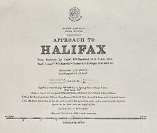 1853 Halifax Nova Scotia Antique Sea Coastal Map Atlantic Canada (1854)
-
$170.98 CAD
 1890 Gulf St Lawrence Quebec Antique Sea Coastal Map Atlantic Canada (1891)
-
$34.20 CAD
 Alaska 1921 annual governors report map radio, telegraph, bird reservations
-
$2325.51 CAD
 Original handcolored engraving by Jan van Vianen, navy , galley 1694., Amsterdam
-
$205.19 CAD
 Bristol Harbor R.I. 1864 Coast Survey Antique Map Topography and Navigation
-
$1573.13 CAD
 1836 South Atlantic Sea Voyage with Tracks Positions Elevations Drawn on Map
-
$184.67 CAD
 Anglo-Spanish War English Channel map by Harrison 1788
-
$205.18 CAD
 Original 1873 Coast Survey Map OREGON WASHINGTON "Tillamook Bay to the Boundary"
-
$150.47 CAD
 1725 Framed Engraving Madagascar -"Voyages de la Compagnie Des Indes Orientales"
-
$266.75 CAD
 5th ANNUAL 25% OFF SALE South Seas Map CAPTAIN COOK 'Feb 1st 1777' 21" x 17"
-
$752.36 CAD
 Original 1831 Friesz Nautical Map GUADELOUPE Marie-Galante Desirade Caribbean
-
$47.88 CAD
 Index Map of Fenwick's Island, South Carolina 1887
-
$957.56 CAD
 Bay of Cattaro Kotor Nautical Map of Port Montenegro Italy Serbia Yugoslavia
-
$136.79 CAD
 1902 antique map nautical chart Alaska lighthouses gold crab
-
$54.72 CAD
 1903 map of Alaska boundary tribunal coast & geodetic survey
-
$102.60 CAD
 1897 Guadalupe island California US coast survey antique map white sharks


