 Antiques (CA)
-
$20.57 CAD

 TOURIST MAP OF SYDNEY AUSTRALIA 1940'S
-
$193.45 CAD
 RARE 1883 Colonial British New Guinea Map. Areas East of Port Moresby
-
$415.18 CAD
 1916 Thomas Hewitt Large Folding Antique Map of Southern Tasmania w/ Hobart
-
$54.89 CAD
 Vintage Map PACIFIC OCEANIA GLC-7N 9th Edition 5/1966🇺🇸57”x41” USAF NAV CHART
-
$2473.36 CAD
 Rare 1891 Alexander Black Contour Map of Mornington Peninsula Victoria Australia
-
$78.62 CAD
 1974 Brisbane Flood Large Map + Official QLD Dept. of Lands Accompanying Letter
-
$175.78 CAD
 RARE 1899 Colonial Western Part British New Guinea Huge Folding Map.
-
$140.45 CAD
 RARE 1894 Colonial British New Guinea Map of Tauwara or Milne Bay
-
$193.45 CAD
 RARE 1892 Colonial British New Guinea Large Map of The Gulf of Papua. #2
-
$193.45 CAD
 RARE 1894 Colonial British New Guinea Large Map of Collingwood Bay & Cape Nelson
-
$44.16 CAD
 OLD PORT PHILLIP BAY MAP CHART HARBOUR AND CHANNEL LIGHTS 1959 VIC MRLBOURNE
-
$79.49 CAD
 OLD MAP 1st ED COLAC VICTORIA AUSTRALIAN MILITARY MAP 1942 WW11 ANZAC
-
$26.49 CAD
 OLD MAP 1st ED DARRIMAN GIPPSLAND VICTORIA AUSTRALIAN MILITARY MAP
-
$981.34 CAD
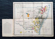 1876 Thomas & Tayler Scarce Antique Goldfields & Minerals Map of New South Wales
-
$228.79 CAD
 .RARE c1859 ROUTES to AUSTRALIA & NEW ZEALAND ex “RAMBLES in the ANTIPODES”
-
$717.13 CAD
 1861 Arrowsmith Rare Antique Map of Queensland, Australia - Brisbane to Warwick
-
$53.53 CAD
 ANTIQUE AUSTRALIA MAP 1900s FRENCH ENGRAVING SYDNEY OLD VINTAGE DOUBLE PAGE RARE
-
$335.67 CAD
 1824 Large Sea Chart Voyages French Polynesia, Duperrey Carte des îles Pomotou
-
$717.13 CAD
 1882 Edward Stanford Large Folding Antique Map Eastern Australia, QLD, NSW, Vic
-
$529.12 CAD
 .1890 SUPER RARE VERY LARGE OFFICIAL QLD GOV MAP OF “ENVIRONS of NORMANTON"
-
$31.79 CAD
 WARRAGUL GIPPSLAND MAP DEPT OF MINERALS AND ENERGY 1ST EDITION AUSTRALIA
-
$44.16 CAD
 OLD MAP CORIO VICTORIA AUSTRALIAN MILITARY MAP ROYAL AUSTRALIAN CORPS
-
$308.29 CAD
 RARE 1906 Colonial British New Guinea Large Map. The Summit of Mt Albert Edward.
-
$140.45 CAD
 RARE 1901 Colonial British New Guinea Large Map. Sketch of the Kumusi River.
-
$164.70 CAD
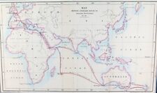
 1829 Map of Pacific, George Pollard, Whaleship "Essex", Nantucket "Two Brothers"
-
$193.45 CAD
 RARE 1896 Colonial British New Guinea Large Map. Mambare River to Gosisi Village
-
$193.45 CAD
 RARE 1896 Colonial British New Guinea Map. Mambare River & Kumusi Valley
-
$149.28 CAD
 RARE c1900 Colonial British New Guinea Large Map of The Morehead River
-
$717.13 CAD
 1854 Arrowsmith Rare Antique Map Plan of Gladstone, Queensland Australia (82045)
-
$264.12 CAD
 RARE 1906 Colonial British New Guinea Large Map. Tamata to Mt Albert Edward.
-
$717.13 CAD
 1854 Arrowsmith Rare Antique Map, Town Plan of Gladstone, Queensland, Australia
-
$175.78 CAD
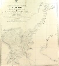
 RARE 1914 British New Guinea Large Sketch Map of Fly & Alice Rivers
-
$131.62 CAD
 RARE 1899 Colonial Western Part British New Guinea Huge Folding Map. #2


