 Antiques (CA)
Africa Maps
Asia Maps
Australia/Oceania Maps
Celestial Maps
Central America/Caribbean Maps
Curiosities Maps
Digital Maps
Europe Maps
Map & Globe Mixed Lots
Map & Globe Reproductions
North America Maps
South America Maps
World & Celestial Globes
World Maps

-
$23.33 CAD

 Antique 1885 Map Early Voyages & Discoveries of North America 8x10
-
$415.36 CAD
 1916 Thomas Hewitt Large Folding Antique Map of Southern Tasmania w/ Hobart
-
$10.28 CAD
 NATIONAL GEOGRAPHIC MAP OF THE INDIAN OCEAN REGION 1941 WWII VINTAGE
-
$8.91 CAD
 NATIONAL GEOGRAPHIC MAP STATE OF ILLINOIS 1931 VINTAGE
-
$102.98 CAD
 1888 Noll’s New Road, Driving, And Bicycle Map Of Philadelphia 34.5” x 21”
-
$82.37 CAD
 1920 National Geographic Europe Map Paris Peace Conference Boundary Redraw WWI
-
$94.74 CAD
 19th C. Map United States (West)-Texas- Engraved & Hand Color -Mackenzie 1867
-
$48.06 CAD
 1905 Leuzinger’s Foldout Relief Map Of Switzerland - German And French
-
$27.45 CAD
 1951 Political Wall MAP OF THE WORLD Printed in Color Decorative Border Railways
-
$480.59 CAD
 Large Folding Map of Newfoundland 1925 47" X 58" Dissected on Linen 2 Sec. - C1
-
$171.64 CAD
 Rare 1869 D. Valentine's Map City of New York Showing Political Divisions, Etc.
-
$34.31 CAD
 Original 1920 Named Trails Road Map WASHINGTON Yakima Spokane Electric Railroads
-
$96.10 CAD
 Original Antique Map LAKE CHAMPLAIN 1732 Land-Grant Survey Chambly Crown Point
-
$72.77 CAD
 ORIGINAL: A PLAN OF MAESTRICHT with ADJACENT VILLAGE WHERE THE BATTLE - MAP 1747
-
$53.55 CAD
 ANTIQUE AUSTRALIA MAP 1900s FRENCH ENGRAVING SYDNEY OLD VINTAGE DOUBLE PAGE RARE
-
$8.88 CAD
 SWITZERLAND, AUSTRIA AND NORTHERN ITALY MAP FROM NATIONAL GEOGRAPHICS 1965
-
$54.92 CAD
 Philips’ Authentic Travelling Maps - Russia (South) Map folds 7.5 x 4.5 Booklet
-
$137.31 CAD
 61” x 53” 1914 Rand McNally Color Foldout Cloth Map Of British India
-
$109.83 CAD
 Original MAP OF FRENCH & ENGLISH GRANTS ON LAKE CHAMPLAIN New York Vermont Pease
-
$13.72 CAD
 1947 Map WEST INDIES CENTRAL AMERICA Cuba Costa Rica Panama Canal Puerto Rico
-
$1029.83 CAD
 Huge Folding Map DOMINION OF CANADA 1924 49" X 102" Dissected on Linen 4 Sec. 6A
-
$13.73 CAD
 National Geographic Society THE WORLD MAP Physical Political 1994 43 x 30 inches
-
$34.31 CAD
 VINTAGE 1918 NATIONAL GEOGRAPHIC MAP OF THE WESTERN THEATRE OF WAR 32 1/2" X 27"
-
$38.38 CAD
 Rand-McNally state map: MISSOURI - c.1991 - paper - highway
-
$3432.74 CAD
 Original 1863 Pocket Maps J. Calvin Smith NORTHEAST US & C.H.V. Cavis WHITE MTNS
-
$31.57 CAD
 Large-Format 1932 Boundary Disputes WORLD MAP Railroads Manchuria Bolivia Peru
-
$1.37 CAD
 Vintage 1959 National Geographic Map of Northeastern United States
-
$1632.62 CAD
 1848 Phelps’s Travellers Guide through the United States & Map
-
$53.55 CAD
 ANTIQUE UNITED STATES MAP 1900's WASHINGTON FRENCH ENGRAVING US OLD VINTAGE RARE
-
$10.28 CAD
 THE NATIONAL GEOGRAPHIC SOCIETY MAP OF NORTHERN AFRICA 1954 COLONIAL ERA
-
$7.54 CAD
 THE NATIONAL GEOGRAPHIC MAP CLOSE UP USA NEW YORK NEW JERSEY PENNSYLVANIA 1977
-
$7.54 CAD
 THE NATIONAL GEOGRAPHIC MAP CLOSE UP USA WISCONSIN & MICHIGAN 1973 VINTAGE
-
$205.90 CAD
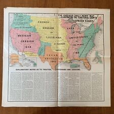 ~1899 The Chicago Daily News' Map Illustrating The Territorial Growth of the US
-
$82.39 CAD
 Map New Caledonia (Nouvelle Caledonie ) c. 1900 (30" x 40") in French
-
$54.92 CAD
 1950 KROLL'S MAP OF ALASKA 35½" x 48½" Color Roads Railroads Index PRE US STATE
-
$38.43 CAD
 Original 1911 National Geographic Railroad Map MEXICO Monterrey Zacatecas Mérida
-
$68.66 CAD
 1951 KROLL'S MAP OF ALASKA 35½" x 48½" Color Lithographed Roads Railroads Index
-
$27.46 CAD
 Antique 1917 Political Map MICHIGAN ~ Representative Districts ~ UPPER PENINSULA
-
$409.18 CAD
 Antique Japan Map Photo-Litho 1899 Railroads Steamship Lines Coal Tea Oil Rice
-
$7.54 CAD
 THE NATIONAL GEOGRAPHIC MAP CLOSE UP CANADA SASKATCHEWAN & MANITOBA MAP 1979
-
$185.35 CAD
 Map FRONTIERS OF THE NORTHERN COLONIES + 1768 Fort Stanwix Treaty with Indians
-
$13.72 CAD
 Large-Format 1936 Map CANADA Highways Railroads Steamship Routes Moose Factory
-
$48.04 CAD
 VINTAGE 1917 HAMMONDS LARGE SCALE WAR MAP of the WESTERN FRONT W/INDEX
-
$26.23 CAD
 Slavery Emancipation US 1977-1865 1910's Vintage Map Folded Wall Art
-
$171.64 CAD
 C. 1830s J.H. Goldthwait Foldout Color Map Book Of Massachusetts
-
$34.33 CAD
 Antique French military map conquest of Algeria
-
$34.31 CAD
 1950 Map COLONIAL AFRICA Arabia Congo Kenya Nigeria Rhodesia Gold Coast Zanzibar
-
$185.37 CAD
![[World War I] 1st Edition Clason's War Map Indexed of the Western Front 1918](https://i.ebayimg.com/thumbs/images/g/zTMAAOSwQQ5hUejO/s-l225.jpg) [World War I] 1st Edition Clason's War Map Indexed of the Western Front 1918
[World War I] 1st Edition Clason's War Map Indexed of the Western Front 1918
-
$13.72 CAD
 FRANCE - antique Map circa 1900
-
$27.46 CAD
 Antique 1917 Map MICHIGAN ~ 7th Congressional District ~ St Clair, Macomb, Huron
-
$611.03 CAD
 064 Antique Original 1760 map of Ukraine, Bulgaria, Russia, Turkey, Georgia
-
$377.60 CAD
 037 Antique Original 1789 Map Kyiv region Ukraine Poland Vincenzo Pazzini Carli
-
$137.30 CAD
 Original 1849 Antique Map LAKE CHAMPLAIN ~ Chambly to Crown Point ~ Land Survey
-
$34.31 CAD
 1941 Map NORTHWESTERN US & CANADA Washington Oregon British Columbia Alberta
-
$611.03 CAD
 044 Antique Original 1645 map of Ukraine, Moldavia, Russia, Georgia Black Sea
-
$27.46 CAD
 Original Antique 1917 Map MICHIGAN ~ 6th & 8th Congressional Districts DETROIT
-
$67.28 CAD
 19th C. Map Denmark- Engraved & Hand Colored -William Mackenzie 1867
-
$67.28 CAD
 19th C. Map Germany-Bavaria- Engraved & Hand Colored -William Mackenzie 1867
-
$1064.15 CAD
 054 Antique Original 1665 map of Ukraine, Podolia, Poland Guillaume Sanson RARE
-
$67.28 CAD
 19th C. Map Sweden & Norway- Engraved & Hand Colored -William Mackenzie 1867
-
$67.28 CAD
 19th C. Map Greece- Engraved & Hand Colored -William Mackenzie 1867
-
$27.46 CAD
 Antique 1917 Political Map MICHIGAN ~ Senate Districts ~ DETROIT & GRAND RAPIDS
-
$27.46 CAD
 Antique 1917 Map MICHIGAN ~ 11th Congressional District ~ PRESQUE, ALPEN, LUCK
-
$12.36 CAD
 Rare National Geographic Folding Map of Illinois Copyright 1931 Free Ship! #5B
-
$73.80 CAD
 Vintage Rare 1909 OHIO MAP - CONGRESSIONAL DISTRICTS - RAILROADS - ELECTRIC LINE
-
$27.46 CAD
 Antique 1917 Political Map MICHIGAN ~ Representative Districts ~ Wayne, Oakland
-
$102.98 CAD
 1761 Antique Map BELL ISLE Belle Ile Brittany France Palais Star-Shaped Citadel
-
$27.46 CAD
 Antique 1917 Political Map MICHIGAN ~ Representative Districts ~ Kalamazoo, Kent
-
$27.46 CAD
 Antique 1917 Political Map MICHIGAN ~ Representative Districts ~ LOWER PENINSULA
-
$27.46 CAD
 Antique 1917 Political Map MICHIGAN ~ Senate Districts ~ LOWER PENINSULA
-
$48.04 CAD
 Original 1830 Menzies Map SCOTLAND Edinburg Inverness Perth Aberdeen Loch Ness
-
$67.28 CAD
 19th C. Map Italy - Engraved Plate & Hand Colored William Mackenzie London 1867
-
$27.46 CAD
 Large Original Antique 1917 Map MICHIGAN ~ 2nd & 3rd Congressional Districts
-
$67.28 CAD
 19th C. Map North America- Engraved Plate & Hand Color by Mackenzie London 1867
-
$67.28 CAD
 19th C.Map Italy #2 (Sicily) Engraved Plate & Hand Colored Mackenzie London 1867
-
$67.28 CAD
 19th C. Map France - Engraved Plate & Hand Colored William Mackenzie London 1867
-
$67.28 CAD
 19th C. Map Asia- Engraved Plate & Hand Colored by William Mackenzie London 1867
-
$67.28 CAD
 19th C.Map China- Engraved Plate & Hand Colored by William Mackenzie London 1867
-
$67.28 CAD
 19th C.Map India (South)- Engraved Plate & Hand Colored by Mackenzie London 1867
-
$67.28 CAD
 19th C.Map India (North)- Engraved Plate & Hand Colored by Mackenzie London 1867
-
$27.46 CAD
 Antique 1917 Political Map MICHIGAN ~ Congressional Districts ~ LOWER PENINSULA
-
$96.12 CAD
 GERMANY 1939 REICHSKARTE KARTE DES SAARLANDES LARGE ORIGINAL FOLDING MAP
-
$67.28 CAD
 19th C.Map Belgium - Engraved Plate & Hand Colored William Mackenzie London 1867
-
$446.26 CAD
 035 Antique Original 1783 map of Ukraine, Moldova, Romania,Pannonia Dacia RARE!!
-
$67.28 CAD
 19th C. Map of United States(East)- Engraved Plate &Color -Mackenzie London 1867
-
$205.95 CAD
 Original 1864 Comstock & Cassidy New York Map + Agricultural Transactions Book
-
$1.37 CAD
 Vintage 1963 National Geographic Map of Southwest Asia
-
$67.28 CAD
 19th C. Map Africa - Engraved Plate & Hand Colored William Mackenzie London 1867
-
$67.28 CAD
 19th C.Map Ireland - Engraved Plate & Hand Colored William Mackenzie London 1867
-
$48.06 CAD
 1908 Indexed Pocket Map of ASIA - Rand McNally
-
$34.31 CAD
 VINTAGE BAR LE DUC FRENCH 1911 MAP BLACK & WHITE 33" X 23"
-
$611.03 CAD
 050 Antique Original 1666 map of Ukraine, Russia, Georgia, Crimea, Black Sea
-
$748.34 CAD
 063 Antique Original 1740 map of Ukraine, Bulgaria, Russia, Turkey, Georgia
-
$2746.19 CAD
 Original 1846 Tanner Pocket Map NEW ENGLAND Land Grants Canals Railroads Phyfe
-
$1132.81 CAD
 052 Antique Original 1665 map of Ukraine, Podolia , Poland Guillaume Sanson
-
$405.06 CAD
 046 Antique Original 1793 Large map of Russia by Robert De Vaugondy
-
$68.66 CAD
 1922 THE WORLD MAP (Political Division) The National Geographic Magazine
-
$1.37 CAD
 Vintage 1983 National Geographic Map of Atlantic Gateway w Historical Notes
-
$748.34 CAD
 029 Antique Original 1685 map of Bohemia, Czech Republic, Large Jaillot / Sanson
-
$8.24 CAD
 THE NATIONAL GEOGRAPHIC MAP CLOSE UP USA SOUTHEAST STATES 1975 VINTAGE 23”x35”


