 Antiques (CA)
Africa Maps
Asia Maps
Australia/Oceania Maps
Celestial Maps
Central America/Caribbean Maps
Curiosities Maps
Digital Maps
Europe Maps
Map & Globe Mixed Lots
Map & Globe Reproductions
North America Maps
South America Maps
World & Celestial Globes
World Maps

-
$690.32 CAD

 Adolf Stielers Hand Atlas ca 1880. Large folio complete 95 maps
-
$331.36 CAD
 1848 Stieler Stulpnagel Map United States Mexico Texas Missouri Oregon Territory
-
$38.64 CAD
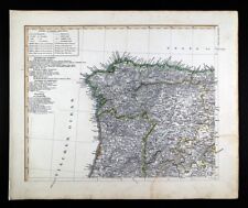 1847 Stieler Map Spain Portugal Porto Coimbra Braga Santiago de Compostela Leon
-
$55.21 CAD
 1848 Stieler Map Scotland Edinburgh Glasgow Dundee Alberdeen Loch Ness Elgin UK
-
$69.02 CAD
 1846 Stieler Map Sweden Norway Denmark Iceland Faroe Islands Stokholm Bergen EU
-
$55.21 CAD
 1848 Stieler Map Ireland Dublin Belfast Cork Limerick Galway Derry Waterford
-
$55.21 CAD
 1845 Stieler Map England Wales London Liverpool Canterbury Cardiff Manchester UK
-
$69.02 CAD
 1846 Stieler Map Sweden Norway Finland Stokholm Christiania Oslo Gotland Baltic
-
$22.08 CAD
 1911 Stieler Map Russia Arctic Urals Kolgujew Archangelsk White Sea Parma Mesen
-
$55.21 CAD
 1847 Stieler Stulpnagel Map Spain Portugal Madrid Lisbon Toledo Barcelona Cadiz
-
$27.60 CAD
 1892 Stieler Map North Italy Rome Florence Venice Milan Corsica Pisa Sienna Alps
-
$220.90 CAD
 1847 Stieler Stulpnagel Map United States Texas Iowa Wisconsin Indian Territory
-
$22.08 CAD
 1911 Stieler Map Russia St. Petersburg Kliew Smolensk Moscow Poland Warsaw Wilna
-
$55.21 CAD
 1839 Stieler Physical Map Europe River Basins Mountain Ranges Rhine Danube Seine
-
$33.48 CAD
 1872 Map of Great Britain Old 19th Century Victorian ANTIQUE
-
$55.21 CAD
 1847 Stieler Map Europe France Spain Italy Germany England Austria Sweden Norway
-
$38.64 CAD
 1911 Stieler Map United States Washington Oregon Montana Wyoming California NV
-
$55.21 CAD
 1848 Stieler Map South America Brazil Argentina Patagonia Chile Colombia Peru SA
-
$27.60 CAD
 1911 Stieler Map Italy Croatia Adriatic Sea Fiume Triest Pola Ancona Rome Plan
-
$44.17 CAD
 1847 Stieler Stulpnagel Map SE Spain Valencia Cartagena Alicante Ibiza Majorica
-
$22.08 CAD
 1911 Stieler Map Mediterranean Spain Gold Coast Ibiza Valencia Alacant Almeria
-
$109.35 CAD
 1841 Stieler Map West Indies Caribbean Cuba Jamaica Martinique Guadeloupe Bahama
-
$33.12 CAD
 1882 Stieler Map Spain Portugal Gibraltar Madrid Lisbon Ibiza Barcelona Porto
-
$19.88 CAD
 1911 Stieler Map Spain Gibraltar Andalusia Portugal Algarve Cordoba Seville
-
$22.08 CAD
 1911 Stieler Map Russia Georgia Caspian Sea Turkestan Caucuses Baku Astrachan
-
$22.08 CAD
 1911 Stieler Map Argentina Chile Falkland Isles Santiago Lima Peru South America
-
$22.08 CAD
 1874 Stieler Map France Paris Plan Bordeaux Pyrennes Rocheforte Toulouse Spain
-
$330.25 CAD
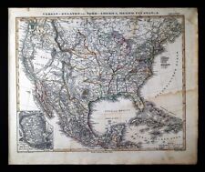
 1847 Stieler Map - United States Texas Mexico California Central America Panama
-
$821.49 CAD
 1866 Stieler Framed World Map- Eastern & Western Hemisphere Set
-
$27.60 CAD
 1911 Stieler Map North Asia Siberia Mongolia China Korea Japan Afghanistan
-
$33.48 CAD
 1873 Map of North America Old 19th Century Victorian ANTIQUE
-
$33.12 CAD
 1911 Stieler Map - Australia Victoria New South Wales Sydney Melbourne Adelaide
-
$13.79 CAD
 1879 Stieler Map Switzerland Germany Alps Mount Blanc France Europe Bern Geneva
-
$22.08 CAD
 1911 Stieler Map SE Brazil Rio de Janeiro Sao Paulo Salvador Bahia South America
-
$22.08 CAD
 1911 Stieler Map Africa Madagascar Somalia Ethiopia Mogadishu Comoros Mayotte
-
$22.09 CAD
 1911 Stieler Map Sweden Norway Finland Russia Poland St. Petersburg Moscow Plan
-
$13.79 CAD
 1882 Stieler Map Germany Sachsen Thuringen Benachbarte Black Forest Frankfurt
-
$22.08 CAD
 1911 Stieler Map Balkans Romania Bulgaria Constantinople Black Sea Turkey Varna
-
$38.64 CAD
 1848 Stieler Map NW France Normandy Brittany le Havre Nantes Rouen Tours Angers
-
$66.26 CAD
 1847 Stieler Map British Isles England Scotland Ireland London United Kingdom UK
-
$16.55 CAD
 1911 Stieler Map Scotland England Edinburgh Glasgow Loch Ness Orkney Shetland Is
-
$38.64 CAD
 1847 Stieler Map NE France Departments Paris Strasbourg Nancy Metz Lille Seine
-
$44.17 CAD
 1911 Stieler Map Colonial Africa South Congo Sudan Ethiopia Nigeria Angola
-
$38.64 CAD
 1892 Stieler Map East Indies Philippines Sumatra Java Singapore Vietnam Thailand
-
$16.55 CAD
 1911 Stieler Map - Rio de Janeiro Brazil - Buenos Aires Argentina South America
-
$44.17 CAD
 1844 Stieler Map South France French Riviera Marseille Toulon NE Spain Barcelona
-
$13.79 CAD
 1874 Stieler Map - France - Paris Chartres Marseilles Le Havre Bordeaux Tours
-
$22.09 CAD
 1911 Stieler Map France Le Havre Paris Marseilles Germany Italy Spain Alps
-
$138.06 CAD
 1847 Stieler Map Australia New South Wales Victoria Sydney Melbourne Adelaide AU
-
$82.84 CAD
 1911 Stieler Map North Sky Star Chart Sirius Polaris Cassiopeia Zodiac Astrology
-
$33.12 CAD
 1911 Stieler Map Ireland Dublin Cork Belfast - Manchester London Plans England
-
$38.64 CAD
 1847 Stieler Map NE Spain France Pyrenees Barcelona Bilbao Menorca Pamplona SP
-
$55.21 CAD
 1847 Stieler Map France Departments Paris Lyon Marseille Bordeaux Strasbourg FR
-
$22.08 CAD
 1911 Stieler Map West Africa Guinea Cameron Kongo Liberia Nigeria Ivory Coast
-
$13.79 CAD
 1874 Stieler Map - Europe Alps - Switzerland Germany France Basel Neuchatel Lake
-
$22.09 CAD
 1911 Stieler Map Sweden Norway Denmark Christiana Stockholm Copenhagen Gefte
-
$33.12 CAD
 1892 Stieler Map Balkans Greece Italy Turkey Romania Bulgaria Serbia Bosnia
-
$16.55 CAD
 1892 Stieler Map Germany Strassburg Metz Frankfurt Coblenz Speyer Stuttgart Ulm
-
$27.60 CAD
 1892 Stieler Map Russia Siberia Asia China Japan Mongolia Turkestan Korea Iran
-
$44.17 CAD
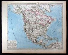 1880 Stieler Map - North America United States Canada Mexico West Indies Alaska
-
$44.17 CAD
 1892 Stieler Map Asia China Japan Korea India Arabia Tibet Nepal Philippines
-
$33.12 CAD
 1892 Stieler Map Russia China Tibet Nepal Mongolia Pakistan Punjab Kashmir Asia
-
$110.45 CAD
 1847 Stieler Stulpnagel Map Australia New Zealand Sydney Melbourne Melville AUS
-
$110.45 CAD
 1847 Stieler Krusenstern Map Australia New Zealand Sydney Melbourne Melville AUS
-
$13.79 CAD
 1879 Stieler Map Sweden Norway Denmark Iceland - Europe
-
$22.08 CAD
 1911 Stieler Map Canada Ontario Quebec Nova Scotia Hudson Bay Great Lakes Maine
-
$13.79 CAD
 1880 Stieler Map - Spain Portugal Gibraltar Madrid Lisbon Ibiza Toledo Barcelona
-
$22.08 CAD
 1911 Stieler Map Balkans Macedonia Serbia Bosnia Albania Montenegro Dalmatia
-
$22.08 CAD
 1892 Stieler Map South America Colombia Venezuela Amazon Brazil Ecuador Peru
-
$13.79 CAD
 1874 Stieler Antique Map Germany France Switzerland Alps Mont Blanc Zurich Bern
-
$16.55 CAD
 1892 Stieler Map France Paris Marseilles Tours Pyrennees Bourdeaux Genoa Spain
-
$13.79 CAD
 c.1880 Stieler Map Atlas Title Page Published in Gotha by Justus Perthes
-
$66.27 CAD
 1847 Stieler World Map Antipodes Polar Projections Land Water North America Asia
-
$66.27 CAD
 1911 Stieler Map - South Sky Star Chart Canopus Sirius Orion - Zodiac Astrology
-
$13.79 CAD
 1876 Stieler Map Germany Sachsen Thuringen Black Forest
-
$33.12 CAD
 1892 Stieler Map North South Dakota Nebraska Minnesota Iowa United States Canada
-
$44.17 CAD
 1911 Stieler Map United States Mexico Canada Cuba Texas New York - North America
-
$27.61 CAD
 1876 Steiler Map Eastern Hemisphere Europe Africa Asia Australia World Antique
-
$16.55 CAD
 1882 Stieler Map - France Spain Switzerland Corsica Paris Marseilles Riviera
-
$44.86 CAD
 1843 ORIGINAL MAP BOHEMIA MORAVIA AUSTRIA ITALY VENETO SLOVENIA LAYBACH AUSTRIA
-
$27.60 CAD
 1911 Stieler Map India Ceylon Bombay Calcutta Pakistan Punjab Mt. Everest Nepal
-
$109.35 CAD
 1847 Stieler Map World Mountain Heights Alps Pyrenees Swiss Austria Profiles
-
$132.54 CAD
 1844 Stieler Map Western Hemisphere North & South America United States Brazil
-
$33.12 CAD
 1892 Stieler Map World Hemispheres Africa Europe Asia Australia America North
-
$38.64 CAD
 1893 Stieler Map United States New York Boston San Francisco Indian Territory OK
-
$27.60 CAD
 1892 Stieler Map India Burma Ceylon Nepal Thailand Bombay Calcutta Madras Goa
-
$16.55 CAD
 1880 Stieler Map Spain Portugal Gibraltar France North Africa Madrid Lisbon
-
$27.60 CAD
 1876 Steiler Map Western Hemisphere - North South America United States - World
-
$27.60 CAD
 1911 Stieler Map South America Brazil Argentina Colombia Peru Chile Bolivia Lima
-
$109.35 CAD
 1847 Stieler World Map Africa Asia Europe South North America Australia Holland
-
$16.55 CAD
 1892 Stieler Map - Germany - Hessen Leipzig Black Forest Dresden Dessau Bohemia
-
$33.12 CAD
 1892 Stieler Map Italy Rome Sicily Naples Vesuvius Etna Florence Venice Croatia
-
$16.55 CAD
 1874 Stieler Antique Map Germany Italy Austria Alps Munich Venice Vienna Milan
-
$27.60 CAD
 1911 Stieler Map Australia Queensland Northern Territory Cape York Carpentaria
-
$22.08 CAD
 1874 Stieler Map - Europe Alps - Austria Salzburg Berchtesgaden Wolfsberg
-
$33.12 CAD
 1892 Stieler Map China Korea Tibet Hong Kong Taiwan Nepal Mongolia Japan Hainan
-
$27.60 CAD
 1892 Stieler Map South Italy Sicily Palermo Naples Capri Salermo Messina Malta
-
$16.55 CAD
 1892 Stieler Map NW France Brittany & Normandy Brest Nantes Le Havre Dieppe Caen
-
$44.17 CAD
 1911 Stieler Map - United States New York City Boston Massachusetts Maine Jersey
-
$27.60 CAD
 1892 Stieler Map Sardinia Cagliari Italy North Africa Tunisia Algeria Tunis


