
-
$102.80 CAD

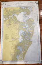 1960 Vintage Nautical Map Atlantic City to Cape May NJ Shore C.&G.S. 38”x24
-
$27.41 CAD
 Newport California Chart #5108 1967 10th Ed
-
$45.22 CAD
 1962 Department of the NAVY H.O. 1400 PILOT CHART OF THE NORTH ATLANTIC OCEAN
-
$35.64 CAD
 Vintage Nautical Map LONG ISLAND SOUND Eastern Part, Milford to New London, CT
-
$51.34 CAD
 Vintage Admiralty Chart ~ Cowes Harbour & River Madina Cowes To Folly Pt No.2793
-
$27.40 CAD
 1962 Matha's Vineyard to Block Island Nautical Map #1210 Anchorage Areas 49"


