 Antiques (CA)
Africa Maps
Asia Maps
Australia/Oceania Maps
Celestial Maps
Central America/Caribbean Maps
Curiosities Maps
Digital Maps
Europe Maps
Map & Globe Mixed Lots
Map & Globe Reproductions
North America Maps
South America Maps
World & Celestial Globes
World Maps

-
$14.11 CAD

 Dept. Of Interior Map - Freemont Peak South Wyoming - 22” x 27” Vintage 1968
-
$14.11 CAD
 Dept. Of Interior Map - Horseshoe Lake Wyoming - 22” x 27” Topo Vintage 1968
-
$14.11 CAD
 Dept. Of Interior Map - Fayetteville Lake Wyoming - 22” x 27” Topo Vintage 1968
-
$41.10 CAD
 Grapevine Canyon Arizona 1968 Original USGS Topo Map Mojave County Folding Paper
-
$34.43 CAD
 IRAN Folding COLOR MAP with Geographic Reference & Index in RUSSIAN Moscow 1966
-
$34.43 CAD
 YUGOSLAVIA Folding COLOR MAP with Reference and Index in RUSSIAN Moscow 1965
-
$8.25 CAD
 USGS Topographic Map, Merced, Ca 7.5 minute series, 1961, Scale 1:24,000
-
$11.00 CAD
 Clifdale North Carolina USGS Topographic Map 1963 1:50,000 Scale Edition 6-AMS
-
$13.77 CAD
 Vintage 1960 US Geological Survey Topographic Quadrangle Map of Troy, Idaho
-
$41.10 CAD
 Governors Peak Arizona 1964 Original USGS Topo Map 7.5 Minute Series Folding
-
$67.48 CAD
 Vintage Map Of MOUNT MCKINLEY, Alaska 29.5 X 30.5 Inches
-
$13.77 CAD
 Vintage 1965 US Geological Survey Topographic Quadrangle Map Moscow East, Idaho
-
$41.24 CAD
 Vietnam and Asian Continent Maps Including Indexes & Economic & Topographic Maps
-
$55.07 CAD
 USGS 1961 MAP Yosemite National Park California Topographical
-
$52.31 CAD
 VTG Original 1st Edition US ARMY Corps Of Engineers Map Of Northwestern Asia
-
$10.95 CAD
 Pomeroy Quadrangle 1967 USGS Topo Map 7.5 Minute Series Garfield Co Washington
-
$18.58 CAD
 1963 HOLY LAND ISRAEL JORDAN SYRIA 19" x 25" TOPOGRAPHIC MAP National Geographic
-
$28.92 CAD
 US Forest Service Vintage Clearwater National Forest Map 1962 Lewis And Clark.
-
$34.41 CAD
 VINTAGE 1964 APPALACHIAN MOUNTAIN CLUB MOUNT DESERT ISLAND TOPOGRAPHIC MAP
-
$41.37 CAD
 Poland Color Lithograph Folding Map 1966 Russian Language Large Size & Booklet
-
$34.43 CAD
 SYRIA Folding COLOR MAP with Geographic Reference & Index in RUSSIAN Moscow 1966
-
$40.95 CAD
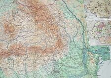 Romania Color Lithograph Folding Map 1966 Russian Language Large Size & Booklet
-
$18.58 CAD
 1967 VIET NAM, CAMBODIA, THAILAND 31" x 40" TOPOGRAPHIC MAP National Geographic
-
$9.63 CAD
 USGS Topographic Map, Merced, Ca 15 minute series, 1962, Scale 1:62,500
-
$34.43 CAD
 IRAQ Folding COLOR MAP with Geographic Reference & Index in RUSSIAN Moscow 1966
-
$20.64 CAD
 VTG Original 1964 US ARMY Corps Of Engineers Map Of Pacific Asia Scale 39” X 54”
-
$13.77 CAD
 Vintage 1965 US Geological Survey Topographic Map Blue Ridge Reserve, Arizona
-
$10.95 CAD
 Grangeville 1964 Army Corps USGS Topographic Map NL 11-8 Oregon Idaho Washington
-
$41.77 CAD
 Bulgaria Color Lithograph Folding Map 1965 Russian Language Large Size & Booklet
-
$17.21 CAD
 Vintage 1962 USGS Santa Maria California Topographic Map
-
$13.76 CAD
 WAYNESVILLE MISSOURI QUADRANT U.S. ARMY MAP SERVICE TOPOGRAPHIC ROAD MAP 1964
-
$17.21 CAD
 Vintage 1962 USGS Kanab Point Arizona Topographic Map
-
$13.77 CAD
 Vintage 1960 US Geological Survey Topographic Quadrangle Robinson Lake, Idaho
-
$11.02 CAD
 Dept. Of Interior Map - Freemont Lake North Wyoming - 22” x 27” Top Vintage 1968
-
$17.89 CAD
 VTG Original 1962 65 US ARMY Corps Of Engineers Map Barcelona & Lisbon
-
$34.43 CAD
 USA Folding COLOR MAP with Geographic Reference and Index in RUSSIAN Moscow 1966
-
$13.76 CAD
 Horse Creek Butte Idaho Quadrangle 1962 USGS 7.5 Minute Topographic Map 19x27
-
$11.02 CAD
 Dept. Of Interior Map - Freemont Lake South Wyoming - 22” x 27” Top Vintage 1964
-
$17.21 CAD
 Vintage 1962 USGS Livingston Hills Arizona Topographic Map
-
$24.07 CAD
 USGS Vintage 1962 Kofa Butte Arizona Topographic Map
-
$65.55 CAD
 USGS Topographic Map CAMPBELLTON CANADA Maine USA - 1963 - 250K - 1° X 2° - flat
-
$11.02 CAD
 Dept. Of Interior Map - Bridger Lakes Wyoming - 22” x 27” Vintage 1968
-
$41.30 CAD
 Kaibab National Forest Service Map 1960 Arizona VTG USDA Grand Canyon North Rim
-
$35.80 CAD
 BORREGO MOUNTAIN CALIFORNIA, USGS 1960 TOPO MAP CHART
-
$20.59 CAD
 Grouse Idaho 1960 Original Vintage USGS Topographic Map 15 Minute Series
-
$38.54 CAD
 Vintage Arsenicker Keys Florida Quadrangle Map Topographic US Geological Survey
-
$39.93 CAD
 JENNY LAKE WYOMING TREASURE MAP GOLD SILVER EMERLDS ! USGS TOPO MAP 1968
-
$27.53 CAD
 USDA Forest Service Topo Map CHIPPEWA NATIONAL FOREST, Minnesota VTG 1961
-
$33.05 CAD
 1960 Business Map ALTUS Oklahoma Great selection of period business ads.
-
$45.44 CAD
 Snelling, California Vintage Original USGS Topo Map 1962
-
$20.59 CAD
 Pasco Washington Quadrangle 1964 USGS Topographic Map 7.5 Minute Series
-
$24.79 CAD
 Vintage USGS Topo Map Capitol Peak Colorado Quadrangle 1960!
-
$24.79 CAD
 Vintage USGS Topo Map Maroon Bells Colorado Quadrangle 1960!
-
$24.79 CAD
 Vintage USGS Topo Map Snowmass Mountain Colorado Quadrangle 1960!
-
$20.59 CAD
 Vintage 7.5 Minute USGS Topographic Map Maroon Bells Colorado Quadrangle 1960
-
$13.76 CAD
 JULIERPASS SWITZERLAND QUADRANT #268 TOPOGRAPHIC MAP VINTAGE 1965
-
$27.54 CAD
 1969 Pocket Creek Lake WY Wyoming Geological Survey Quadrangle Topographical Map
-
$27.54 CAD
 1969 Big Sandy Opening WY Wyoming Geological Survey Quadrangle Topographical Map
-
$27.54 CAD
 1969 Temple Creek WY Wyoming Geological Survey Quadrangle Topographical Map
-
$13.76 CAD
 Degan Mtn. Idaho Quadrangle 1962 USGS 7.5 Minute Topographic Map 19x27
-
$20.64 CAD
 Virgin Quadrangle Utah 1980 Original Vintage USGS Topo Map
-
$13.76 CAD
 Square Top Idaho Quadrangle 1962 USGS 7.5 Minute Series Topographic Map 19x27
-
$13.76 CAD
 Lem Peak Idaho Quadrangle 1962 USGS 7.5 Minute Topographic Map 19x27
-
$13.76 CAD
 Aggipah Mtn. Idaho Quadrangle 1962 USGS 7.5 Minute Topographic Map 19x27
-
$20.64 CAD
 Beaver Lake Mountain Quadrangle Utah 1960 Original Vintage USGS Topo Map
-
$13.76 CAD
 Norton Ridge Idaho Quadrangle 1962 USGS 7.5 Minute Topographic Map 19x27
-
$13.76 CAD
 Chinook Mtn. Idaho Quadrangle 1961 USGS 15 Minute Series Topographic Map 21x17
-
$13.76 CAD
 Mormon Mountain Idaho Quadrangle 1962 USGS 7.5 Minute Topographic Map 19x27
-
$27.53 CAD
 Snowyside Peak Quadrangle ID Sawtooth Forest Topographic Map Vintage 1964 USGS
-
$13.76 CAD
 Mt. Mc Guire Idaho Quadrangle 1962 USGS 7.5 Minute Topographic Map 19x27
-
$13.76 CAD
 Shoup Idaho-Montana Quadrangle 1960 USGS 15 Minute Series Topographic Map 21x17
-
$13.76 CAD
 Papoose Peak Idaho Quadrangle 1962 USGS 7.5 Minute Topographic Map 19x27
-
$18.31 CAD
 1967 color Topographic map of Buzzard Peak, King County Texas. 7.5 minute series
-
$13.76 CAD
 Dave Lewis Peak Idaho Quadrangle 1962 USGS 7.5 Minute Topographic Map 19x27 (B)
-
$13.76 CAD
 Bear Creek Point Idaho Quadrangle 1962 USGS 7.5 Minute Topographic Map 19x27
-
$13.76 CAD
 Puddin Mtn. Idaho Quadrangle 1962 USGS 7.5 Minute Topographic Map 19x27
-
$13.76 CAD
 Hoodoo Meadows Idaho Quadrangle 1962 USGS 7.5 Minute Topographic Map 19x27
-
$13.76 CAD
 Vinegar Hill Idaho Quadrangle 1962 USGS 7.5 Minute Topographic Map 19x27
-
$13.76 CAD
 Blue Joint Idaho Quadrangle 1962 USGS 7.5 Minute Topographic Map 19x27
-
$13.76 CAD
 Dave Lewis Peak Idaho Quadrangle 1962 USGS 7.5 Minute Topographic Map 19x27
-
$13.76 CAD
 Puddin Mtn. Idaho Quadrangle 1962 USGS 7.5 Minute Topographic Map 19x27 (B)
-
$13.76 CAD
 Allison Creek Idaho Quadrangle 1962 USGS 7.5 Minute Topographic Map 19x27
-
$13.76 CAD
 Ramey Hill Idaho Quadrangle 1962 USGS 7.5 Minute Topographic Map 19x27
-
$13.76 CAD
 Ulysses MTN. Idaho Quadrangle 1960 USGS 15 Minute Series Topographic Map 21x17
-
$13.76 CAD
 Shellrock Peak Idaho Quadrangle 1962 USGS 7.5 Minute Topographic Map 19x27
-
$13.76 CAD
 Poison Peak Idaho Quadrangle 1962 USGS 7.5 Minute Series Topographic Map 19x27
-
$13.76 CAD
 Wood Hump Idaho Quadrangle 1962 USGS 7.5 Minute Topographic Map 19x27
-
$4.94 CAD
 US Dept of the Interior Geological Survey Map, Platoro, CO area
-
$45.44 CAD
 LA Grande, California Vintage Original USGS Topo Map 1962
-
$20.64 CAD
 VTG 1968 Rammel Mountain Wyoming USGS Topographical Map TOPO WY 7.5 Minute
-
$20.64 CAD
 Saddle Mountain CA Topographical Map Vintage 1960 California Quadrangle 17 x 21


