
-
$50.60 CAD

 Vintage 1937 Topographic Map - Lyons, Kansas - 19.75" x 16.5"
-
$50.60 CAD
 Vintage 1938 Topographic Map - Syracuse, Kansas - 19.75" x 16.5"
-
$50.60 CAD
 Vintage 1939 Topographic Map - Larned, Kansas - 19.75" x 16.5"
-
$170.99 CAD
 Palm Beach Atlas Sheet 17-A - The Breakers Cocoanut Walk to Barton Ave Whitehall
-
$82.08 CAD
 Chicago Area 1933 Advert Map Of Lombard DuPage Co: Lombard Terrace Acres REPRO
-
$10.88 CAD
 Haverhill Mass. N.H. 16.5" X 20" Vintage 1932 USGS Topographic Topo Map
-
$24.65 CAD
 1935 California Nevada Antique Map J Thomas Co Great to Frame CA NV
-
$478.78 CAD
 SHANGHAI Japanese Antique Map International & French Concessions China 1937 b557
-
$20.52 CAD
 Antique Original Clymer New York Topographic Map Printed 1930 Art Wall Décor
-
$20.52 CAD
 USGS Topographic Map Merrill Michigan Antique Original Printed 1937 16x20 Art
-
$27.35 CAD
 AJO ARIZONA ORIGINAL 1932 USGS QUADRANGLE 27X22 FOLDED MAP EXCELLENT CONDITION
-
$34.02 CAD
 CONSTANTINOPLE City Plan Turkey 9 x 11" (23 x 8cm) - 1934 German Map
-
$20.52 CAD
 Antique Ady Texas Original USGS Topographic Map 1936 16x20
-
$49.23 CAD
 Vintage 1933 Topographic Map - Montezuma, Colorado - 20.75" x 17"
-
$50.60 CAD
 Vintage 1937 Topograpic Map - Minneapolis, Kansas - 19.75" x 16.5"
-
$170.99 CAD
 Palm Beach Atlas Sheet 23-A - Jungle Point - Everglades Island
-
$27.36 CAD
 Germany Hungary Poland 1935 Map Berlin Europe 14 x 11" LGAD99
-
$19.21 CAD
 1936 BAEDEKER MAP - GERMANY City Plan Weimar & Erfurt 4 x 6" 10 x 15cm
-
$20.52 CAD
 Portage New York Original USGS Topographic Map Printed 1932 Antique Art
-
$47.88 CAD
 1932 Yale Expedition to N. India Map C 1934 Amer. Geographical Society, NY
-
$27.36 CAD
 Egypt Map Nile Arabian Desert 1935 Northern Africa Atlas 14 x 11" LGAD99
-
$399.44 CAD
 1939 Vintage Pictorial Map of New York
-
$24.62 CAD
 Map Springfield Maine 1931 Topographic Geo Survey 1:62500 22 x 18" TOPO3
-
$27.36 CAD
 Vintage 1932 USGS Topo Casselton North Dakota 16.75 X 20"
-
$34.19 CAD
 Cohoes NY USGS Topography Map Halfmoon, Stillwater, Waterford, Brunswick, Easton
-
$23.94 CAD
 1934 MAP 6 x 8" (15 x 20 cm) - PALERMO City Plan & Environs Sicily Italy
-
$218.87 CAD
 1887-1937 Pacific Ocean Map Admiralty Chart 39 1/2 X 40 inch W.J.L Wharton
-
$24.62 CAD
 Map Arnold Pond Maine 1932 Topographic Geological Survey 1:62500 22 x 18" TOPO2
-
$46.51 CAD
 Nevada - Sonoma Range Quadrangle (1932 survey) Original...
-
$82.08 CAD
 WWII Era - WAR AND NAVY DEPT. MAP OF ENGLAND & WALES (SHEET 2)
-
$47.86 CAD
 Vintage 1930 Topographic Map - Ashland, Kansas - 19.75" x 16.5"
-
$87.21 CAD
 US Department Of The Interior Geological Survey, Georgia Warm Springs Quad 1934
-
$20.52 CAD
 Vintage 1931 USGS Topo Map- Elm Mott / Waco, Texas 16.5X 20"
-
$31.75 CAD
 1936 MAP GERMANY Deutscheland - Munich Munchen Metro & City Center Plan 9x11"
-
$24.62 CAD
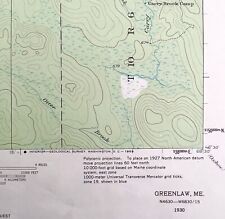 Map Greenlaw Maine 1930 Topographic Geological Survey 1:62500 22 x 18" TOPO2
-
$39.52 CAD
 Vintage Clason's Guide MAP Colorado OIL LEGEND 1920s 1930s RARE
-
$34.06 CAD
 1930 AUSTRALIA Vintage Map New Zealand Oceania ORIGINAL 11.5 x 9.5 Color C12
-
$20.52 CAD
 Canning South Dakota Antique Original USGS Topographic Map 1937 16x20
-
$82.08 CAD
 WWII Era - US ENGINEERS SPECIAL ROAD MAP OF ENGLAND & WALES (SHEET 3)
-
$50.60 CAD
 Vintage 1933 Topographic Map - Lakin, Kansas - 19.75" x 16.5"
-
$20.52 CAD
 Del Sur California Antique Original USGS Topographic Map 1936 16x20
-
$27.36 CAD
 Puerto Rico North America Map 1935 14 x 11" Virgin Islands Caribbean LGAD99
-
$21.29 CAD
 1936 MAP - GERMANY Deutscheland Mannheim & Darmstadt Town City Plans
-
$991.76 CAD
 Vintage, original 1937 THE DOLE MAP OF THE HAWAIIAN ISLANDS - Dole Pineapple
-
$136.78 CAD
 VINTAGE PARCEL MAP THOMAS BROS CITY OF ORANGE ANAHEIM ORANGE COUNTY CA c1930
-
$27.36 CAD
 Vintage 1939 USGS Topo Map, Yreka, California. 16.5 X 20"
-
$25.92 CAD
 Vintage Map Print WWII History Color 2 Sided South Pacific China Japan Taiwan
-
$23.94 CAD
 1934 MAP 6 x 10" (15 x 25 cm) - ORAN City Plan Algeria Africa
-
$25.92 CAD
 Vintage Map Print WWII History Color Argentina Chile Paraguay Uruguay Hawaii
-
$23.26 CAD
 map BARCELONA of Spain Original city plan map 1934
-
$13.68 CAD
 Map 1930 State Claims Western Lands c1783-1802 5.5 x 9" Offset Lithograph DWEE2
-
$16.01 CAD
 1936 BAEDEKER MAP - GERMANY Deutscheland Rostock & Rugen Island 4x6" 10x15cm
-
$20.52 CAD
 Guilford Maine Antique Original USGS Topographic Map 1937 16x20
-
$29.96 CAD
 1930 FAROE ISLANDS Vintage Geographical Map Denmark ORIGINAL 11.5 x 9.5"- C12-5
-
$27.36 CAD
 Vintage 1936 USGS Seiad, California Klamath River Topo Map - 16.5" x 20"
-
$23.94 CAD
 1934 MAP 6 x 8" (15 x 20 cm) - NICE French Riviera Coast France & Italy
-
$20.52 CAD
 Alma Wisconsin USGS Topographic Map Antique Original Printed 1932 16x20 Art
-
$34.19 CAD
 1937 USGS Topo Map WHITE SWAN YAKIMA INDIAN RESERVATION Washington Fort Simcoe
-
$31.75 CAD
 LIBYA Tripoli City Plan 6 x 8" (15 x 20 cm) - 1934 German Map
-
$27.36 CAD
 Vintage 1932 USGS Colorado Springs, Colordo Topo Map - 16.5" x 20"
-
$72.64 CAD
 7 Vintage 1930s 40s PA Dept Internal Affairs Topographical Maps Altoona Tyrone +
-
$15.05 CAD
 1932 Europe Geometric Interpretive Map Print Van Loon Geography Asia Africa
-
$15.47 CAD
 AUSTRIA Gmunden City Plan - 1931 BAEDEKER MAP
-
$20.52 CAD
 Vintage 1931 USGS Topo Map Wellington, Nevada Walker River 16.5 X 20"
-
$33.98 CAD
 1936 MAP - GERMANY Deutscheland Duisburg Dusseldorf City Town Plans
-
$25.92 CAD
 Vintage Map Print WWII History Color Norway Finland Sweden France Great Britain
-
$15.05 CAD
 1932 India Interpretive Map Print Van Loon Geography Bengal Arabian Sea Art
-
$27.36 CAD
 Vintage 1932 USGS Topo La Moure/ Oakes, North Dakota 16.5 X 20"
-
$20.52 CAD
 Napoleon Ohio Antique USGS Topographic Map Printed 1930 16x20 Art
-
$20.52 CAD
 USGS Topographic Map Smyrna Hills Maine Antique Printed 1937 16x20 Art
-
$40.97 CAD
 Greystone Greene County Tennessee NC 1939 Geological Survey Map 27x22 VG
-
$19.21 CAD
 ALGERIA Bone Constantine City Plan 4 x 6" (10 x 15 cm) - 1934 German Map
-
$15.05 CAD
 1932 Nile River Egypt Interpretive Map Print Van Loon Geography Art Sahara
-
$15.05 CAD
 1932 Asia Europe Land Bridge Interpretive Map Print Van Loon Geography Art
-
$17.09 CAD
 VTG 1935 Where to Stay in Boson A Street Map Boston Chamber of Commerce 26 x 17
-
$24.62 CAD
 US Geological Survey Map Scale 1/125000 Topographic Sheet Mount Vernon Stanwood
-
$24.62 CAD
 US Geological Survey Map Scale 1/125000 Topographic Sheet Mount Vernon Standwood
-
$15.05 CAD
 1932 Rhine River Delta Interpretive Map Print Van Loon Geography Art Pen and Ink
-
$15.05 CAD
 1932 Australia New Zealand Geometric Interpretive Map Print Van Loon Geography
-
$9.58 CAD
 1937 South America & 1949 Europe and the Near East National Geographic Maps
-
$20.52 CAD
 Antique Blacksville West Virginia Original USGS Topographic Map 1940
-
$15.05 CAD
 1932 Africa Mediterranean Geometric Interpretive Map Print Van Loon Geography
-
$820.77 CAD
 Parker Edwards Map of Hawaii 1937 Dole Pineapple TIKI History Pictorial 37 X 19
-
$15.05 CAD
 1932 Yangtze Hwang Ho Rivers China Interpretive Map Print Van Loon Geography
-
$29.88 CAD
 1936 MAP GERMANY Deutscheland - Braunschweig & Hildesheim City Plans
-
$34.02 CAD
 1936 MAP - GERMANY Deutscheland Harz Brocken Wernigerode Harzburg Goslar Plans
-
$15.47 CAD
 1931 BAEDEKER MAP - Italy Lake LAGO DI GARDA & Environs + Railroads
-
$82.01 CAD
 1938 Nautical Chart #0826 South Pacific Sheet IV Australia New Guinea 34" x 49"
-
$27.36 CAD
 Vintage 1939 USGS Needles Calif / Arizona Topo Map - 16.5" x 20"
-
$25.94 CAD
 1936 MAP GERMANY Deutscheland - CIty Plans of Trier Bonn & Rhine River
-
$27.36 CAD
 Brazil Guianas South America Map 1935 Atlas Bolivia Argentina 14 x 11" LGAD99
-
$12.80 CAD
 AUSTRIA Styria Mariazell & Environs - 1931 BAEDEKER MAP
-
$8.14 CAD
 1920 Mooseleuk Lake, ME Maine USGS Topographic Topo Map
-
$15.05 CAD
 1932 South America Geometric Interpretive Map Print Van Loon Geography
-
$68.38 CAD
 1937 Plat Map Wisdom Montana Beaverhead County Original Townsite Survey
-
$31.75 CAD
 1936 MAP GERMANY Deutscheland - Bremen & Marburg City Plans
-
$29.88 CAD
 1936 MAP GERMANY Deutscheland - Hanover City Plan Railroads Genealogy
-
$33.98 CAD
 1936 MAP - GERMANY Deutscheland Frankfurt City Plan + Thuringer Wald Forest
-
$82.08 CAD
 WWII Era - US ENGINEERS SPECIAL ROAD MAP OF ENGLAND & WALES (SHEET 5)
-
$82.08 CAD
 WWII Era - US ENGINEERS SPECIAL ROAD MAP OF ENGLAND & WALES (SHEET 6)


